

Author: Asa Letourneau
Online Engagement Officer
Find parish plans by current location name and position them on Map Warper
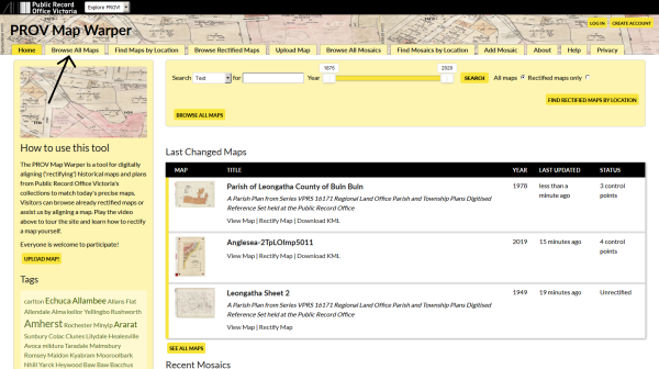
Public Record Office Victoria holds a range of cartographic collections ranging from parish plans to historic plans, MMBW plans and even aerial photographs. While researchers may know the contemporary place names these plans relate to, many would be hard pressed to be able search for them because they're often titled using their historic name, known as a parish.
This is where the new PROV Map Warper service at mapwarper.prov.vic.gov.au comes in. You can now view our historic parish plans by searching on a current location name.
No longer will researchers need to know the historic name Doutta Galla to search for parish plans covering Essendon, Melbourne, Port Melbourne, Broadmeadows and Keilor, or know Jika Jika to search for parish plans covering Brunswick, Coburg, Collingwood, Fitzroy, Heidelberg, Melbourne, Northcote, Preston, Richmond and Broadmeadows.
We need your help!
With PROV Map Warper we can layer our historic maps and plans onto an online map so you can use a slider to see the difference between the old map and the current place. We need your help to position them correctly over a digital map of Victoria to make this happen. It's really easy and it's quite fun if you're a bit of a map nerd!
Below we outline in a few steps just how easy it is to join our team and help make this happen. This process is called rectification and it allows us to visualize how places have evolved over time.
To see a short video of how Mapwarper works take a look at this short instructional video then jump on board and help us rectify maps in your area.
- To join the PROV Map Warper team just create an account using an email address and sign in then you'll be ready to start working with maps.

Now you'll need a map to rectify.
2. You can search for maps using keywords like place names or geographic features to bring up a selection of our digitized images. You can also browse the entire collection of digitized maps. Just click on Browse All Maps on the top left.
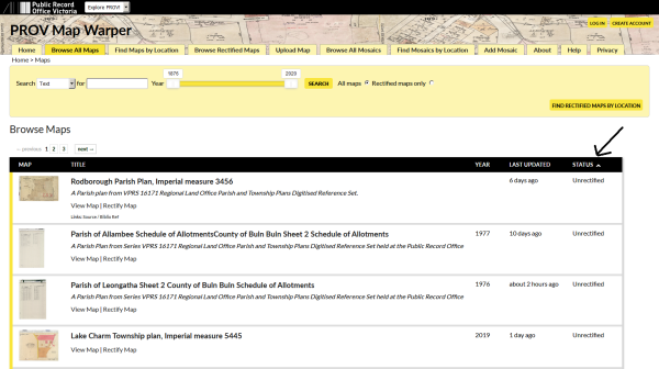
3. The status column on the right will tell you if the image has been already rectified. You can bring the unrectified ones to the top by clicking on it. These are the maps we need you to help us rectify or position.
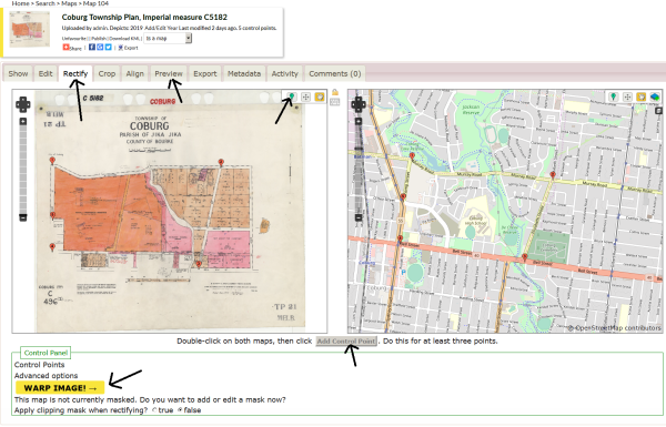
4. Once you've chosen a map from the list by clicking on its title click the rectify tab. This will bring up a split screen with your historical map image on the left and a mapping tool on the right. Please note, you’ll only see the rectify tab if you have logged in! You'll notice that each frame has the standard web map navigation controls. Now you can begin matching locations on the historical map image with coordinates on the web mapping tool. Click the map pin icon and mark a pair of corresponding points on both maps then click add control point. If you don’t click add control point your points won’t be saved! For best results, you should add at least four pairs of control points. Adding points to street intersections or railway crossings is an easy way to rectify a map. Once you have added at least four pairs of control points click on the Warp Image button. This is very important. To see your rectified map click the preview tab.
.
You can share your rectified map on your favourite social media platform, export it to Google Earth or email it to family and friends by clicking on the relevant icons.
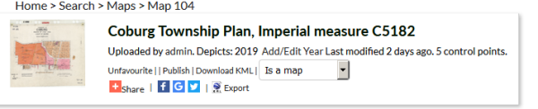
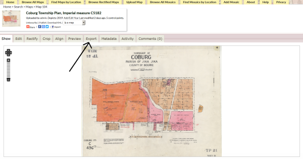
You can download the geospatial data such as the ground control points (i.e. map points) by clicking on the export tab.
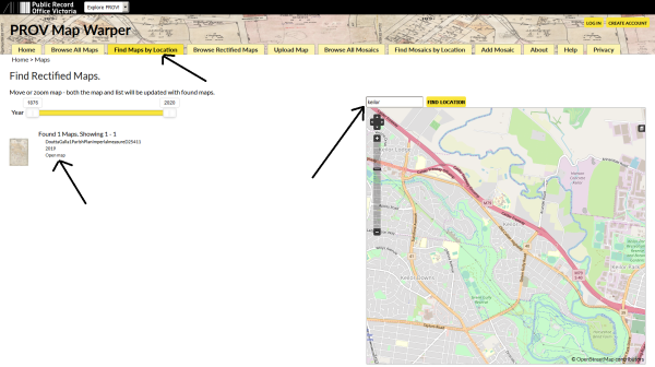
To see the great work that others have already done just click on Find Maps By Location. You can simply enter a modern day location name and Map Warper will find the corresponding rectified map. No need to remember historic location names! Choose the map you want from the left hand side list by clicking on Open Map. Once the map opens just click on the Preview tab to see it overlayed on the real world.
And that covers the basics. If you have any issues, contact us via our facebook page, https://www.facebook.com/PublicRecordOfficeVictoria and we will respond as soon as possible.
We at Public Record Office Victoria hope you'll join our online Map Warper team and help bring the past into the digital present.
If you’d prefer to see the above steps as a video you’ll find one on the home page of the PROV Map Warper at mapwarper.prov.vic.gov.au.
Material in the Public Record Office Victoria archival collection contains words and descriptions that reflect attitudes and government policies at different times which may be insensitive and upsetting
Aboriginal and Torres Strait Islander Peoples should be aware the collection and website may contain images, voices and names of deceased persons.
PROV provides advice to researchers wishing to access, publish or re-use records about Aboriginal Peoples