Last updated:
‘Landscapes of Abundance and Scarcity on the Northern Plains of Victoria’, Provenance: The Journal of Public Record Office Victoria, issue no. 7, 2008. ISSN 1832-2522. Copyright © Robyn Ballinger.
This is a peer reviewed article.
The contemporary landscape of the northern plains of Victoria is the outcome of cultural interaction with an unpredictable physical environment. In this article I argue that settlement visions for the northern plains in the period 1836-1930 were shaped not only by political and economic imperatives but also by the climatic variations of a semi-arid country. This article examines the history of one particular section of land, and contends that settlement visions developed around ideas of scarcity and abundance have had far-reaching consequences for plains’ dwellers and for the country itself.
The northern plains of Victoria[1] are a place of both scarcity and abundance. They experience a median annual rainfall of 420 mm. But to speak in terms of medians does not describe the rain that falls to double this figure, or the rain that falls to halve it. The northern plains are not a place of norms or averages, and like other semi-arid regions they have drawn varied responses.[2] Some white settlers described a place transformed by rain into a sea of waving grasses as far as the eye could see; others spoke of the plains without water as parched and unwelcoming. Shaped by individual motivations, societal attitudes, and the seasonal shifts of the country itself, some have reacted to it as a place of promise, others as a place of disappointment.
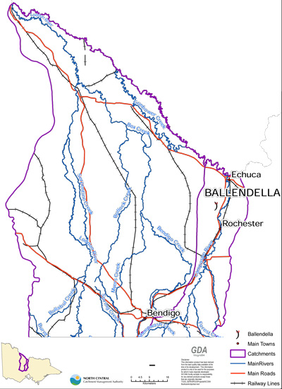
Informative studies of how cultural attitudes and appraisals of the physical environment have influenced patterns of settlement in Australia have been undertaken, notably, by historical geographers DW Meinig, RL Heathcote and JM Powell.[3] This article extends the themes of these studies by contending that dominant appraisals of the northern plains of Victoria were constructed around ideas of abundance and scarcity influenced by the country’s semi-arid climate. Using documentary records such as those held by Public Record Office Victoria, this article explores cultural interactions with the northern plains through an analysis of settlement visions applied to one particular section of land over the eras of squatting, selection, and closer settlement. By undertaking an historical micro-study of a section of land that lies within the present-day Victorian township of Ballendella, approximately 80 kilometres northwest of Bendigo (see Figure 1), it is possible to trace how the larger dynamic processes of culture and nature continually describe one another to form local landscapes.
The plains country is of itself an abundant place, a finely balanced ecosystem that functions as its own living entity. Its natural features have provided a home for Indigenous and non-Indigenous people in turn. Today’s Ballendella comprises part of the homeland of the Barababaraba people.[4] Like other Indigenous peoples of the River Murray, the Barababaraba hunted and collected seasonally, farmed land through fire-stick burning, engineered waterways, and altered their social and territorial interaction at times of climatic fluctuation.[5] Over thousands of years, they learnt to work within the limitations of the plains, for it was this country that sustained them both spiritually and physically. Despite this, the explorer Surveyor General Thomas Mitchell viewed the northern plains as an ’empty’ space. Mitchell’s heavily promoted vision of his journey through the area in the wet year of 1836,[6] published in newspapers in Sydney and Britain and in his book Three expeditions into the interior of eastern Australia, described the landscape in terms of its potential for Europeans, for what it could become. In imagining it ready for white settlement, Mitchell negated Aboriginal experience of the plains as homeland. Yet, in the name of the Ballendella township and parish there is a link to New South Wales Aboriginal woman Turandurey and her daughter, Ballendella, who accompanied the expedition.
Squatters brought their herds and flocks to the Port Phillip district from 1834, however it was not until 1841 that they first moved into the northern plains to claim the country for their own.[7] With increased stock numbers and most of the better-watered land of Port Phillip already claimed, fierce competition forced run seekers to move further afield to find fresh pastures. In 1840 there remained only the areas of Gippsland, the Wimmera, the Mallee, and ‘the scantily watered plains in the north’.[8] In initial assessments of the country’s grazing capacity, the northern plains with their intermittent water supply and patterns of seasonal vegetation growth were judged as wanting. However, following rains that transformed the country in 1841, the first runs on the plains were taken up along the Campaspe, Murray and Loddon Rivers. Based on the capitalist notion of economy, the business of sheep and cattle stations relied on the water and fodder potential of the northern plains to produce the commodities of livestock, meat and wool. Waterways were dammed, Aboriginal soaks enlarged,[9] channels excavated from rivers and swamps, and, as the climate varied, people and stock relocated.
The changing landscape of pastoralism can be traced through the documentary record held for Restdown Plains station taken up on the Campaspe River in 1841 by John Hays for Captain George Benson.[10] In looking for land for a run, David Munro came across Restdown Plains in the drought year of 1842, the same year the station was sold to David Kelsh. Munro was less than impressed with what he saw:
The country is dead level, on either side of the river are large clear open spaces, the surface of which exposes about 3/4ths of sand and a fourth of weeds, not grass, of that sickly blue colour which we see on the poor moorland pastures at home. These open spaces are backed by the eternal sad looking forest. Yet here we found a gentlemanly well educated man in this dismal wilderness submitting himself to a course of life, which if inflicted upon a malefactor would be denounced as cruel.[11]
Affected by the financial crisis of 1842, Kelsh sold the station and his 3500 sheep to Alexander Sim in November 1843.[12] In March 1848, Sim stocked 500 cattle and 12,000 sheep on a run of 106,922 acres that incorporated a head station and nine outstation huts, six of which were located on the Campaspe River.[13] In 1853, new licensee John Pearson Rowe was making the most of the growing demands of the goldfield markets. In January of that year, stock numbers had risen significantly to 1110 cattle, 16,000 sheep and 19 horses.[14] In 1855, after subdividing the run into Restdown Plains East and Restdown Plains West, Rowe continued to bring merino wethers from Queensland for sale in Bendigo, fattening the sheep at Restdown Plains West in conjunction with his other run held at Terrick Terrick on the northern plains. Like other squatters who took over runs on the plains from the mid-1850s to exploit the opportunities of the burgeoning goldfields, Rowe responded to the unpredictability of the climate by using his northern runs in winter, and, when dry seasons occurred, building up stock on his better-watered Five Mile Creek run in Gippsland.
The effects of the business of pastoralism on native flora and fauna, and on the Barababaraba people who depended on these food sources, were soon evident. Squatter Edward Curr, traversing the northern plains from the Campaspe River to Mount Hope in the early 1840s, noted the impact of stock after only two years of grazing:
In places … around Mount Hope and the Terricks … the salt bushes occasionally attained the height of twelve feet … in other localities a dwarf variety of this plant prevailed, and grew so close together as almost to crowd out the grass entirely. With this class of vegetation great changes have occurred, and at Mount Hope … stocking has almost entirely destroyed it.[15]
In 1853, squatter Charles Hall recorded the drop in numbers of kangaroos, emus, quail and turkeys in the Loddon and Wimmera districts, which he had explored earlier in 1840-42.[16] In addition to a reduction in food resources, the use and alteration of watercourses impacted dramatically on Aboriginal populations. Squatters established runs along the same watercourses that Aboriginal people depended on. Grazing regimes mirrored traditional Aboriginal movements: in winter, animals were fed and watered in the ‘back country’ away from rivers, and in summer they were moved to water frontages.[17] Gerard Krefft in 1857, in remarking on the site of an Aboriginal rock well at the Terricks, noted that it was ‘not accessible to the herds of sheep and cattle, who went to drink at a muddy pool in the flat, which contained a thick liquid of a greenish colour the greater part of it being comprised, to judge by the smell, of sheep and cattle dung’.[18]
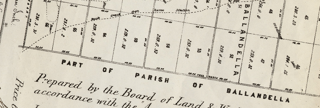
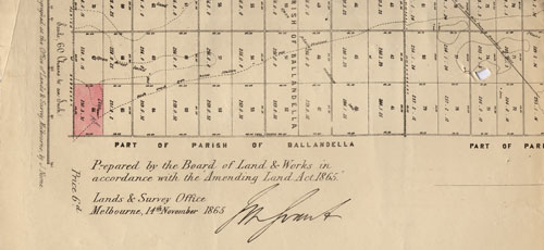
Squatter notions regarding use of the plains for extensive winter pastoral runs did not accord with official visions of a more closely settled country. The Land Acts of 1860, 1862 and 1865 aimed instead to settle farmers on the plains, however squatters continued to consolidate and expand their holdings. In preparation for selection under the Land Act 1865 for instance, the Restdown Plains West run was surveyed into allotments of between 80 and 400 acres. The then owners of the run, Alexander Boyd and Francis Bell, took up the majority of the selections themselves through the illegal means of dummying.[19] With the introduction of the strict residency and cultivation conditions of the Land Act 1869, however, a determined push was made by the colonial government to transform places like the northern plains, which by then were controlled largely by only twenty-nine men, into a patchwork of rural holdings.[20]
Heavy rains brought selectors to the plains from the early 1870s under the Land Act 1869, which opened up all unalienated land in the colony to selectors with runs of up to 320 acres.[21] Licences (Section 19s) were taken up for three years at an annual rental of 2 shillings per acre. These licences required the selector to develop the land by living on-site for at least two and a half years, and within three years building a house to fulfil residency conditions, fencing the selection, cultivating at least ten per cent of the land, and affecting other advances such as the clearing of vegetation, the construction of water storages, and the erection of outbuildings. If improvements at a rate of £1 per acre were made within this time, the selector could either purchase the land freehold by paying the balance of 14s. per acre, or obtain a seven-year lease (Section 20) paid at an annual rent of 2s. per acre and credited as part payment of the fee simple.
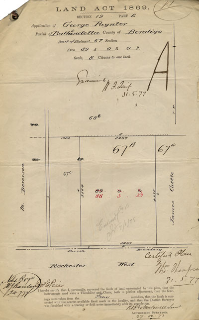
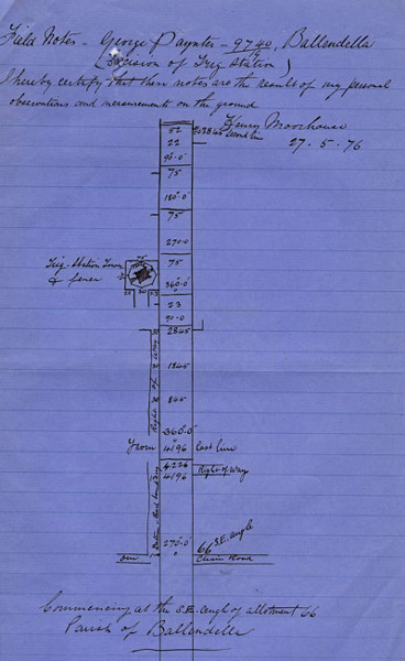
Under this Act, unmarried Rochester farmer George Paynter took up land on the former Restdown Plains West run in the newly surveyed parish of Ballendella. Paynter selected two allotments: 230 acres in July 1871 and 89 acres in December 1873. On the first block, after a weatherboard cottage with shingle roof and a slab hut had been built, fences erected, dam and well dug, and 70 acres cultivated to wheat, he applied for a lease in February 1876. On his second allotment, after enclosing the land with post-and-rail sapling and chock-and-log fences, and grubbing and clearing 18 acres, he applied for a lease in April 1877. At the same time, the erratic nature of the country was brought into sharp relief by a series of dry years over the period 1876-81.[22] Paynter, in order to pay debts perhaps incurred because of the continuing drought, mortgaged the lease on his first allotment in July 1878 for £200, and the lease on his second selection in May 1879 for £100. He was able to pay back these debts and make the required rental payments under the terms of the lease, coming to own his farms freehold in March 1882 and February 1884.[23] Many other selectors however were less fortunate and had to sell their farms or transfer their leases. On the northern plains, the population of the East Loddon Shire fell from 3400 in 1877 to 2000 in 1882, and in the Echuca Shire from 12 000 in 1877 to 8200 in 1882.[24]
Settlers on the semi-arid plains such as Paynter increased their vulnerability to the disaster potential of meteorological drought through the removal of vegetation, as required under the cultivation and improvement conditions of the Land Act 1869. As a result of these practices, soil from the northern plains was carried great distances by the wind. Widespread ‘red’ rain coloured by dust from wind erosion of the soils of inland Victoria was recorded across the colony in April 1884.[25] Moreover, the continuous cropping of the soils of the plains, initially fertile because of centuries of accumulation of silt deposited by rivers, resulted in ‘grain sick’ land and decreasing yields, especially over the drought years of this period. In the counties of Bendigo, Gladstone, Gunbower and Tatchera, average annual wheat yields fell from 9.2 bushels per acre in 1877-78 to 5.6 bushels per acre in 1882-83.[26] The ideal of settling a yeomanry on small farms was increasingly challenged as the land could not provide the returns that were required to meet the debts of the selectors. Consequently, cultural constructions began to emphasise the inability of the plains country to support more intensive farming systems. When the northern plains failed to make their expected contribution to the economy in the 1880s, instrumental expectations were disappointed. Likewise, when Land Acts failed to settle people as envisaged, territorial approaches reformulated the plains as the ’empty north’.[27] From the 1880s, a concerted effort was then made to reverse the decline by controlling environmental fluctuations through human intervention.
The Federation vision of Australia as an industrial landscape of production linked to international markets had to look to technology and science if such a vision were to be realised. Severe droughts across the nation in the periods 1895-1903 and 1911-16 highlighted the necessity of incorporating the climate into a program that sought to reduce all aberrant forms to fit national ideals. As land-use patterns based on the ideas of science were applied, environmental vagaries were denied and notions of agricultural settlement limited by rainfall isohyets were deemed outmoded. From the early 1900s the northern plains became the focus of prevailing institutional narratives based on ‘land, labour, and capital’. State agendas of closer settlement, and federal programs of soldier settlement and migration settlement accompanied by the delivery of an irrigated water supply promised to bring certainty to an uncertain landscape.
As part of the closer settlement vision, under the Closer Settlement Act of 1904 a number of estates on the northern plains were made ready for the reception of irrigator settlers. On the former Restdown Plains West run, selections were purchased, stock removed, channels surveyed, and land subdivided into 184 allotments averaging 50 acres to form the new irrigated Bamawm Estate. J Roy, State Rivers and Water Supply Commission (SRWSC) District Secretary, reported on the remaking of the landscape in March 1910: ‘The Estate is entirely clear of all recent occupants and all stock. Owing to the recent heavy rainfall the Estate looks very luxurious, in fact I have not seen it in such a good state at this time of the year for over 20 years.’[28] The following year, however, brought drought. Channels had not been completed, and Roy was obliged to report that water for domestic use was being carted to families on the Estate.[29]
In April 1911, Harold Waterman, dairyman of Poowong in South Gippsland, applied for a fifty-acre irrigated block of land, which in 1841 had comprised part of the Restdown Plains run of 106,922 acres, and in 1873 had formed part of Paynter’s selection of 89 acres.[30] Waterman’s lease on the Bamawm Estate block required him to make half-yearly payments of £21 over 31½ years in order to pay off his allotment valued at £718 15s. In 1912, Harold, twenty-five years old, his wife Lillian aged twenty-eight, and two small children were living in a two-roomed unlined house with verandah paid for by a £70 advance from the Closer Settlement Board. A water tank, dam, shed, fowl house and fencing were listed as other improvements, and the family had sown three acres of maize, ten acres of wheat and three-quarters of an acre of onions. In the first few years, Harold supplemented the family’s income by working on the channels under construction in the area and Lillian sold produce from the garden to canning factories in Bendigo.
By July 1912, 88 of the 138 lessees on the Bamawm Estate were requesting assistance by way of cash advances or deferred payments. Roy listed the causes of failure to meet payments as the limited carrying capacity of allotments until lucerne was established, small returns from dairy cows because of insufficient fodder due to dry seasons, inexperience in irrigation and cultivation, and expenditure of available capital. Harold was judged a ‘first class man’ by Roy, however in July 1913, after no payments had been made on £115 due in instalments, the Waterman family was informed that their permit for the area was to be cancelled and that the land would be made available to others. A written plea from Harold to SRWSC chairman Elwood Mead resulted in a reversal of this decision, but the demands from the SRWSC did not stop. By the dry year of 1914, because of a predicted shortage of fodder owing to the drought, the Watermans were hopeful that a return of £120 on six cuttings of their lucerne crop would allow payment of arrears. However, the ‘unprecedented drought’ of 1914-15 meant that irrigators were not supplied their allocated water, and by 27 January 1915 the Watermans owed £234 in instalments and £151 on a stock mortgage to the Commission. Because of the drought, the government established a scheme in April 1915 which allowed Closer Settlement lessees ‘to improve their financial position by removing present pressing financial liabilities’. The Watermans applied for an extension of their lease and suspension of land instalments for three years but were refused as their debt was in excess of the security provided by their improvements.
On 4 March 1916, Harold enlisted in the Australian Imperial Force, serving as a motor transport driver in France until the end of the war. This action at least secured Lillian Waterman and her four children an eight shilling a day payment. Lillian, with the help of her eldest son and neighbours continued to farm the block in Harold’s absence. Roy reported in 1916 that he found the place better than when Harold was working it, with the ‘whole area now cultivated’, however with part of the block under water because of the heavy rains of 1917, local farmers and members of the settlers’ association were called upon to help. Friends, the Ballendella Progress Association and the Anzac Society carried out ‘praiseworthy work’ over three days on the Waterman’s leasehold, pruning twenty acres of fruit trees, and ploughing, harrowing and drilling sixteen acres of wheat and barley.
In July 1919, Harold returned home from France and moved back into the two-roomed house with his wife and four children. At his request, the block was brought under the Discharged Soldiers Settlement Act in 1920, but 1922 was one of the driest years on record across the northern plains. At the end of 1924, the Commission informed the Watermans that the ‘utmost leniency’ had been shown them, and because no payment had been made since a deposit on the land in 1911, no further delay could be permitted. The family was managing an orchard of twenty-one acres of prunes, apricots and peaches, a lucerne crop of thirteen acres, barley and oat crops of four and eight acres respectively, and milking two cows in July 1924 when Roy visited to report on progress. Later in the same year, Roy wrote that prospects for the family were improving:
He [Waterman] has a splendid show for the coming season from his orchard and states that he feels sure that he will be able to pay at the very least a lump sum of £100 from the sale of his fruit … His prospects never looked so good as at present and although seriously in arrears I am hopeful that from the next fruit season he will rapidly reduce his arrears.
The SRWSC threatened ‘drastic action to compel a settlement’ twice in 1925. Harold had promised a payment of £50 from the proceeds of the sale of dried fruit but because of a slump in the price of this commodity owing to large quantities arriving at the Melbourne markets from South Australia, and because 1925 was another dry year, the Watermans did not realise the expected returns.
Letters demanding payment of outstanding arrears of £990 remained unanswered throughout 1926, and six memos sent to Roy in the first half of 1927 brought only one response from Lillian who informed the Commission that Harold was in Caulfield Military Hospital recovering from an operation necessitated by war disabilities; she hoped that ‘some day we will be able to straighten matters out’. In July 1927, £712 of the Watermans’ arrears were written off under the terms of the amended Discharged Soldiers Settlement Act. In October of that year the Closer Settlement District Enquiry Board reported that Harold’s health had been detrimentally affected by the war, and recommended that no pressure be made for payment for two years and that instalments on arrears be spread over three years. However, even under these conditions no payments were forthcoming, and by October 1930 the Watermans were in arrears by £483. In February 1931 their consolidated debt was £1299, and by June 1933 their debt measured £1543. Harold wrote in November 1930 that ‘with the exceedingly low prices for all our products, the best intentions in the world cannot produce more returns until the markets look up’. Roy took a somewhat different view, however, describing the land as good and Harold as sober but noting his propensity to ‘mess things up like Barwood’. The Closer Settlement Act of 1932 provided for the adjustment of accounts of all settlers, and in 1937 the Watermans’ liability was reassessed at £1287. Harold, Lillian and their son managed their forty-two acres of fruit trees as a registered partnership from the late 1930s, and in January 1944 gained a freehold title to the block by paying off the closer settlement liability of £1271 5d in full. Almost thirty-two years after moving onto their fifty-acre block at Ballendella, Harold and Lillian Waterman finally owned their land.
The story of the Waterman family records the realities of life under the official vision of irrigated closer settlement. Paradoxically, as environmental uncertainties were downplayed, ‘hazard risks’, shaped by the vagaries of distant markets and climatic variability, were amplified. As Heathcote has argued, official policies encouraged ‘the transformation of the variety of the original ecosystems into commercially productive and simpler ecosystems. The results have been an increased ecological and economic vulnerability [original emphasis]’.[31] Farmers who used irrigation came to depend on a regular water supply over the summer growing months. In dry periods, when this supply was reduced or dried up altogether, they were unable to realise the financial return on which their livelihood depended. Moreover, irrigation schemes radically altered the natural hydrology of the plains, left little water in reserve for dry seasons, and raised salinity levels. In seeking to bring certainty to the northern plains through the introduction of new technologies, the country was only made more uncertain, and its reputation as a place of capriciousness was entrenched.
This article, through a close study of one section of land, has highlighted the processes that conditioned the making of settlement visions for the northern plains, and has traced the impact of these visions on the landscape and on the people who lived there. These same settlement visions were applied throughout Victoria, and indeed Australia. The point to be made here, and one which this article has defined, is that the northern plains became a particular focus of larger economic and political agendas because of the country’s very nature – a nature that defied human demands for patterns of ordered white settlement expected to contribute to the economic prosperity of the individual, the state, and the nation.
The documentary record testifies to the conflict between human dreams and environmental actualities. The place itself, the physical environment, has been, and continues to be, an active agent in the settlement process. By telling the story of how people have exploited the opportunities and minimised the challenges thrown up by the environmental variability of the plains, it is evident that populations have increased their vulnerability to climatic variations by moving ‘further down the rainfall gradient’[32] into semi-arid regions, and, in doing so, have judged the country as defective. Perceptions of the plains reflect the physical abundance and scarcity brought to the country by a variable rainfall, but just as importantly reflect the potency of mental landscapes that imagine abundance and scarcity. With growing concerns about human-induced climate change, a new epoch of uncertainty has begun. If the future is to be imagined in any meaningful way, past and present reactions to uncertainty need to be understood. Our role as creators of landscapes needs to be recognised by coming to know the difference between the actualities of the country and the country inside our heads.
Endnotes
[1] The ‘northern plains’ in this study refers to the bioregion of the Victorian Riverina that lies west of the Campaspe River.
[2] The delineation of the study area as part of a semi-arid climate zone is based on MC Peel, BL Finlayson and TA McMahon, ‘Updated world map of the Köppen-Geiger climate classification’, Hydrology and earth system sciences, vol. 11, 2007, pp. 1633-44. The updated Köppen-Geiger climate map is also available online.
[3] DW Meinig, On the margins of the good earth: the South Australian wheat frontier, 1869-1884, Monograph Series of the Association of American Geographers no. 2, Rand McNally, Chicago, 1962 (reprinted by Rigby Limited, Adelaide, 1976); RL Heathcote, Back of Bourke: a study of land appraisal and settlement in semi-arid Australia, Melbourne University Press, 1965; JM Powell, The public lands of Australia Felix: settlement and land appraisal in Victoria 1834-91 with special reference to the Western Plains, Oxford University Press, Melbourne, 1970.
[4] Based on Aboriginal language boundaries in ID Clark, Aboriginal languages and clans: an historical atlas of Western and Central Victoria, 1800-1900, Monash Publications in Geography no. 37, Department of Geography and Environmental Science, Monash University, Melbourne, 1990, p. 388.
[5] Colin Pardoe, for instance, suggests that at the end of the glacial epoch 7000 years ago, Aboriginal people on the River Murray developed a fundamentally different social order: C Pardoe, ‘Riverine, biological and cultural evolution in southeastern Australia’, Antiquity, vol. 69, no. 265, 1995, pp. 696-713.
[6] Rainfall was not officially recorded at weather stations on the northern plains until 1881. Information about rainfall before that time has been gleaned from anecdotal evidence contained in written accounts and from rainfall records kept at Bendigo from 1862.
[7] The term ‘squatter’ first applied to those pastoralists who took possession of land before legislature was introduced in 1836. It is adopted in this article because it was widely used in the literature of the time.
[8] Sir Stephen Roberts, History of Australian land settlement, 2nd edition, Macmillan, South Melbourne, 1968, p. 169.
[9] Soaks were shallow depressions excavated into soft sandy sediments above a slowly permeable clay subsoil. They were used to catch rain, or were sometimes dug to tap into the water table.
[10] JO Randell, Pastoral settlement in Northern Victoria, vol. 2, The Campaspe District, Chandos Publishing Company, Burwood, Victoria, 1982, p. 549.
[11] D Munro, Letter dated 17 August 1842, ML A6936-2, Manuscript Collection, Mitchell Library, State Library New South Wales.
[12] Randell, The Campaspe District, pp. 551-2.
[13] PROV, VA 538 Department of Crown Lands and Survey, VPRS 5920/P0 Pastoral Run Papers, sheet 688, pastoral run no. 1083 (microfiche copy of VPRS 5359).
[14] ibid.
[15] E Curr, Recollections of squatting in Victoria, 2nd edition, Melbourne University Press, 1965, p. 86.
[16] Letter from Charles Browning Hall, 6 September 1853, in Letters from Victorian pioneers, edited by CE Sayers, Currey O’Neil, South Yarra, Victoria, p. 268 (originally edited by TF Bride for the Trustees of the Public Library, Museums, and National Gallery of Victoria, Melbourne, 1898).
[17] ‘Boort revisited – Mr Godfrey, the pioneer, interviewed’, Boort Standard, 25 September 1892.
[18] Quoted in Johann Louis Krefft, ‘Narrative of the exploring expedition led by W. Blandowski to the Lower Murray and Darling Rivers 1856-7’, Gerard Krefft Manuscript and Pictorial Collection c. 1856-1895, ML A268 CY 754, Manuscripts Collection, Mitchell Library, State Library of New South Wales.
[19] ‘Dummies’ were nominal selectors acting on behalf of someone else to apply for land or to fulfil residency conditions.
[20] Based on run information in R Spreadborough & H Anderson (comps), Victorian squatters, Red Rooster Press, Ascot Vale, Victoria, 1983.
[21] Bendigo, which has a median annual rainfall of 550.7 mm, received 974.6 mm in 1870, and 715.3 mm in 1871.
[22] Below-average rainfall was recorded in Bendigo in the years 1876, 1877, 1878 and 1879. At the nearest rainfall station at Echuca with a median annual rainfall of 423.2 mm, 376.7 mm in 1881 and 306.8 mm in 1884 were recorded.
[23] PROV, VA 538 Department of Crown Lands and Survey, VPRS 625/P0 Land Selection Files, sections 19 and 20, 1869, Unit 162, 9470/19.20 and Unit 577, 46016/19.20.
[24] Victorian Year Book, Government Printer, Melbourne, for the years 1877-78 and 1882-83.
[25] HA Hunt, Results of rainfall observations made in Victoria 1840-1910 including all available rainfall totals from 1,114 stations; together with maps and diagrams, Commonwealth Bureau of Meteorology, Melbourne, 1911?, p. xxxvi.
[26] Victorian Year Book, 1877-78 and 1882-83.
[27] Instrumental orientations regard the environment merely as resources awaiting current or future development for material ends, and territorial orientations frame the environment as property to be owned or at least controlled. Se E Cohen in RL Heathcote, ‘Manifest destiny, mirage and Mabo: contemporary images of the rangelands’, Rangeland journal, vol. 16, no. 2, 1994, pp. 156-7.
[28] PROV, VA 2266 Closer Settlement Board (previously known as Lands Purchase and Management Board 1905-1918), VPRS 5714/P0 Closer (and Soldier) Settlement Files, Unit 1130, ‘Bamawm Estate’.
[29] ibid.
[30] Information on the Waterman family is drawn from PROV, VPRS 5714/P0, Unit 1559, Item 4489/12 ‘Ballendella’; National Archives of Australia, Australian Imperial Force, Base Records Office, ‘Waterman, Harold: Service Number-11943’ and First Australian Imperial Force Personnel Dossiers, 1914-1920, B2455/1; The Age, 26 June 1918.
[31] RL Heathcote, ‘Summary and conclusions: the role of perception in the desertification process’, in Perception of desertification, ed. RL Heathcote, United Nations University Press, Tokyo, 1980.
[32] RL Heathcote, ‘Drought mitigation in Australia: reducing the losses but not removing the hazard’, Great Plains quarterly, vol. 6, 1986, p. 227.
Material in the Public Record Office Victoria archival collection contains words and descriptions that reflect attitudes and government policies at different times which may be insensitive and upsetting
Aboriginal and Torres Strait Islander Peoples should be aware the collection and website may contain images, voices and names of deceased persons.
PROV provides advice to researchers wishing to access, publish or re-use records about Aboriginal Peoples