
Last updated:
‘Land, water and property: surveying the Boort pre-emptive right’, Provenance: the Journal of Public Record Office Victoria, issue no. 21, 2023-24. ISSN 1832-2522. Copyright © Peter Davies & Susan Lawrence.
This is a peer reviewed article.
Surveyors in colonial Victoria were responsible for turning land into property. The maps and plans they created imposed geometric patterns on landscapes that represented white ownership and control and the appropriation of Indigenous land. Under the 1847 Orders in Council, squatters could apply for survey and purchase of a pre-emptive freehold of at least 160 acres, giving them security over their homesteads, yards and other pastoral ‘improvements’. Control of water was a vital part of this process, especially on the dry plains of northern Victoria. Pre-emptive rights typically secured access to reliable water in creeks or rivers, but the law forbade control of dual water frontages to prevent undue monopoly of water supplies. The ‘Frederick Byerley Case’ provides important insight into the determination of land, water and property boundaries in colonial Australia, and how surveyors negotiated the conflict between private rights and the public interest. In 1857, Frederick Byerley surveyed a pre-emptive freehold at Boort Station on the lower Loddon floodplain. His plan included both sides of the highly ephemeral Kinypanial Creek to incorporate a small weir the station-owners had constructed to capture and hold more water in the creek channel. This inclusion was later deemed unlawful and led to Byerley losing his job in the Survey Department. He protested his dismissal, and a parliamentary select committee was commissioned in 1858 to decide on the case. The case hinged on whether the terminus of the creek was still in its natural state and thus subject to the regulations that prohibited monopolies of double frontages, or if the weir had created an artificial water storage or pond, in which case the regulations would not apply and Byerley’s dismissal was in error. The case highlights the complexities of applying imported English laws to topographic features that confounded colonists’ implicit assumptions about the permanence of water.
Surveying and mapping are vital first steps in abstracting land and water into private property. The process, which has a long history, accelerated rapidly in the early modern era with the creation of ‘neo-Europes’ in settler-colonial societies and the dispossession of Indigenous peoples.[1] The lines and angles measured by surveyors created geometric shapes that asserted European ownership of appropriated lands, a process that historian Andro Linklater has described as ‘the most potent idea in economic history’.[2] Plans, maps and titles became the legal instruments that regulated and rationalised the process of converting Aboriginal Country into settler leaseholds and freeholds.[3] Western maps and plans were political documents that both described territory and asserted ownership of it. Property created by the control of land and water became not only the private possession of the colonisers but also a commodity to buy, sell, lease and bequeath. Often the new shapes inscribed were at odds with the features of the lands they enclosed because the new arrivals lacked knowledge and understanding of what they sought to control. Here we present one small incident in the settler mapping of Victoria to analyse the tensions between European expectations implied in surveys and the distinctive characteristics of Australian environments.
The process of surveying and selling land in colonial Victoria was complicated by its squatting history. By the time pastoral land was alienated in the 1850s, pastoralists had already been in occupation for nearly 20 years. They had built homes and sheds, stockyards and fences. These were considered ‘improvements’ and squatters converting parts of their leases into private land had the opportunity to retain their facilities in pre-emptive freeholds. Among the structures that squatters sought to retain were dams and tanks that provided reliable water for horses, sheep and cattle. This was to prove problematic for government officials. It was government policy to maintain equitable access to water to support closer settlement, but where pastoralists had excavated or enlarged existing waterholes or redirected streams, these modifications to the natural flow of water were considered ‘improvements’ that squatters were determined to retain.
Provision of access to water was an essential part of the colonising process on the dry plains of northern Victoria. Reliable supplies were a crucial element of successful pastoralism in the nineteenth century, but water was often in short supply. Landholders responded to water scarcity by creating earthworks, such as channels, dams, weirs and levees, to capture and divert creek and river flows and retain water for longer periods. Modifications to ephemeral creeks, swamps and lagoons meant that these natural floodplain features became partly cultural places as well, honed to fit human projects and aspirations.[4] Small earthworks created by squatters in the 1840s and 1850s caused subtle but significant changes to local hydrological patterns, turning wetlands into lakes and ephemeral waterholes into semi-permanent ponds. These changes had important consequences for defining water bodies and for delineating land and property boundaries.[5]
The importance and scarcity of water was acknowledged in the strict rules and regulations that governed how access to water was allocated during the survey and sale of pastoral land. The 1847 Order in Council created new laws that regulated the sale and occupation of Crown lands in the Australian colonies. Squatters in ‘unsettled districts’ could now apply to obtain 14-year leases over their pastoral runs and purchase a pre-emptive freehold of at least 160 acres at a minimum of £1 per acre, giving them much greater security over their runs.[6] Access to secure water was usually included in the pre-emptive allotments in addition to the homestead, yards and other improvements. The order also set out regulations about water frontages on pre-emptive rights that prohibited both sides of any stream from being included within the freehold. The intention was to prevent individual pastoralists from monopolising water supplies and to promote the ‘beneficial occupation and cultivation’ of adjoining lands by other settlers.[7] The rules permitted a maximum of 1,760 yards (1 mile) of water frontage in a pre-emptive right of 1 square mile. It gradually became common practice, however, to include both sides of minor creeks, giving half a mile of water frontage, where surveyors believed this would not be detrimental to the public interest (see the case of the Glenalbyn run, below).
The surveying of pre-emptive rights and allocating of water access was closely monitored by all concerned—lease holders, government officials, neighbours and politicians. It could be a contested and public process. Much was at stake, from the livelihood and prosperity of individuals and families, to the careers of politicians conscious of the public cries to make land available for closer settlement. The case of Surveyor Frederick Byerley and the pre-emptive right for Boort Station provides an example of what could go wrong and how an apparently straightforward decision by a local surveyor, one of hundreds made every day, could become the subject of intensive inquiry and scrutiny. This case also provides a glimpse into learning processes in the new colony, as those claiming the land struggled to make sense of the rhythms of the country they were taking. The controversy that engulfed Byerley draws attention to disjunctures and gaps between what the colonists expected based on their experiences of wetter countries elsewhere and what they encountered in Australia. It reveals colonists coming to terms with the new world they found and how they tried to wrestle both the physical environment and their own cultural and legal systems into something they could control.
Boort Station was a squatting run located on Yung Balug/Dja Dja Wurrung and Barapa Barapa Country on the lower Loddon floodplain in northern Victoria. In 1854, leaseholder Henry Godfrey requested a survey to establish a 640-acre pre-emptive right. The following year, Hugh Frazer surveyed the pre-emptive section but, in the process, excluded both the Boort woolshed and a dam at the terminus of Kinypanial Creek. These were ‘improvements’ that Godfrey wanted to retain as part of his pre-emptive freehold. Godfrey requested changes to the allotment boundary and, in September 1857, Frederick Byerley resurveyed the land, adjusting the pre-emptive right to include the woolshed and two huts, a paddock fence and a section of Kinypanial Creek with the dam. The inclusion of water frontage on both sides of the creek was later deemed unlawful and led to Byerley’s downfall. When he lost his job in the Survey Department because of the Boort resurvey, Byerley protested his dismissal on the grounds of precedent, practicality and his personal integrity. The case led to a parliamentary select committee to inquire into the circumstances of his dismissal and to the creation of a series of detailed maps of the area, now in Public Record Office Victoria.[8]
Byerley’s survey at Boort and its aftermath provides important insight into the redrawing of land, water and property boundaries in colonial Australia and how this process created rural landscapes. Surveyors were charged with turning regulations into reality. They set out the lines of roads, fences and farms and defined water bodies. In so doing, they made Country into property and established the shapes of settler occupation.[9] Surveyors navigated the often-conflicting demands of squatters and Crown lands bureaucrats, interpreted laws and regulations often drafted in ignorance of local conditions, and tried to fit these expectations onto remote rural landscapes.[10] The ‘Frederick Byerley Case’ reveals the contest between private rights and public interest in the colonial era, how ambiguities and tensions in the process of survey, lease and purchase of Crown lands were navigated and negotiated, and the role played by cultural perceptions of waterways.
Boort Station
Henry Godfrey (b. 1824) came to Victoria in 1843 and took up the Boort Station in 1846 in partnership with John Bear. Frederic Godfrey (b. 1828) arrived in Victoria the following year and joined his brother at Boort, until leaving the partnership in 1864. The Boort pastoral run consisted of 64,000 acres (100 square miles) of Loddon River floodplains and large patches of mallee scrub, with the homestead and yards built close to the eastern edge of Lake Boort.[11] The run was bounded by the Loddon River on the east, while boundaries with neighbouring runs were defined by fences, blazed trees and ploughed furrows.[12] The property had an estimated carrying capacity of 12,500 sheep in 1855.[13] By 1863, Boort Station had expanded to 113,400 acres, most of which remained leasehold.[14] Henry Godfrey held the Boort run until around 1871, when Dr Robert Farie purchased the pre-emptive freehold and leased the remainder of the station. By 1874, the run was held by the Armstrong brothers, although land selection had reduced its extent to about 10,000 acres.[15] The final leaseholder of the station was George Holloway, in 1884.[16]
The Godfreys arrived during a wet period when there was abundant water in creeks and swamps. During the dry years that followed in the late 1840s, however, these sources dried up and the Godfreys were keen to improve their water supply. They focused their efforts on Kinypanial Creek, a small, ephemeral channel that originally rose on the northern slopes of granite ranges near Wedderburn and flowed north towards Fernihurst before diverging north-west and terminating in Lake Boort. At one location, the Kinypanial passes close to the Loddon River and, in August 1850, Frederick Godfrey and John Hunter Kerr of the neighbouring Fernihurst Station measured height levels between the two watercourses with the intention of establishing a connecting channel. High flows in the Loddon would enter the cut and flow down Kinypanial Creek towards Boort, scouring the channel more deeply and providing more water for the station. Local Aboriginal people were employed initially, and the excavation of the channel was completed by shearers in September 1850.[17] During the following winter, water flowed through the 700-metre long cutting into Kinypanial Creek and down to Boort.
The white settlers regarded Kinypanial Creek as a peculiar feature of the floodplain. It was both a ‘blind’ (highly ephemeral) creek and a ‘waster’, a distributary that diverted high flows in the Loddon away from the river channel and ‘wasted’ them on the plain.[18] The creek flows for approximately 20 kilometres north-west across the floodplain from the Loddon River to Boort station, with the channel extending several hundred metres into the shallow bed of Lake Boort. ‘Lake’ Boort is another characteristic feature of the plains. It is one of more than a hundred wetlands in the lower Loddon region that, in its unmodified condition, alternates between high water and being completely dry. Its water levels are now artificially managed; however, previously it had filled every decade or so during flood years, holding water for a few years before entering a dry phase until the next flood. The lake was full when the Godfreys arrived at Boort but slowly dried out and, by 1848, the Godfreys had already taken steps to improve their water supply. They constructed a low weir across the creek channel where a natural waterhole extended into the lake bed not far from the station homestead. The weir captured flood flows and stored more water for longer within the waterhole. Local historian Paul Haw describes how the weir was built from two rows of timber pegs or stakes with rails between and the space packed with soil. Low embankments were constructed back to the edge of the lake from both sides of the weir, enabling the creek to hold more water. Haw suggests that the Yung Balug probably constructed the original weir as a fish trap, similar to examples described in the area by explorer Thomas Mitchell[19] and pastoralist Peter Beveridge near Swan Hill.[20]
Henry Godfrey applied to the colonial secretary for his 640-acre pre-emptive right at Boort Station on 6 January 1854, only a few weeks before he and his wife Mary departed for a two-year trip to England. Frederic Godfrey wrote to the colonial secretary in March 1854 ‘anxious to know’ if the application would be approved, before paying £672 at 21 shillings per acre to the Treasury in December 1854 as purchase money for the pre-emptive right freehold. Godfrey submitted a livestock return the following year showing the station ran 10 horses, 520 cattle and 12,500 sheep.[21] Hugh Frazer surveyed the pre-emptive right in 1856 and submitted his plan as part of a map that included the pre-emptive right of the Torpichen run to the south and the old road from the Korong (Wedderburn) goldfield to Boort.[22] Frazer’s 1856 survey showed the southern edge of the Boort pre-emptive right extending to the centreline of Kinypanial Creek, not the bank (Figure 1). This reflected the riparian tradition of the time, in which property owners adjacent to rivers or lakes held their land ‘to the middle of the stream’, and prevailing Victorian regulations that prevented landowners from owning both sides of a permanent watercourse.[23]
[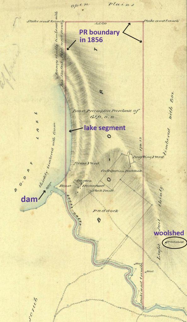
Figure 1: The pre-emptive freehold of Boort Station surveyed by Hugh Frazer in 1856 that includes a segment of Lake Boort but excludes the Godfreys’ woolshed. PROV, VPRS 8168 Historic Plan Collection, P0002, GF14, Line of Old Road from Torpichen Korong Goldfields to Boort, Hugh Frazer, 10 May 1856.
When Henry Godfrey returned from England in July 1857 he complained about Frazer’s survey to the Board of Land and Works. He noted that it excluded his woolshed but included a section of Lake Boort that should have formed the boundary, and thereby he lost ‘about fifty acres of land’. He claimed his overseer had remonstrated with Frazer but to no effect. Godfrey requested a resurvey of the section so that he would gain the full 640 acres of land that he had paid for, including his improvements.[24] Accordingly, in September 1857, Frederick Byerley surveyed an alteration of the pre-emptive right. He corrected the western boundary to exclude the arc of Lake Boort and extended the eastern boundary to include the Godfreys’ woolshed. He reduced the northern extent of the section and extended the southern boundary to enclose both sides of Kinypanial Creek so that paddock fences and the modified waterhole were included (Figure 2). He submitted his plan to the Survey Office in Melbourne in early December 1857 along with a letter highlighting his departure from the regulations to include the Godfreys’ improvements and went on with his work in the district.
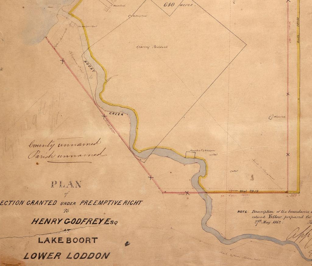
Figure 2: Frederick Byerley’s survey of the Boort pre-emptive right in 1857 marked in pink, which includes both sides of Kinypanial Creek. The yellow line shows the new pre-emptive allotment surveyed by Frederick Harding in 1862, with the right bank of the creek forming the boundary. PROV, VPRS 8168, Historic Plan Collection, P0007, PR: L41, Boort: Lake Boort.
Frederick Byerley’s dismissal
In April 1858, Byerley received a letter of suspension on the grounds that he had departed from the regulations in giving the Godfreys both sides of Kinypanial Creek. Byerley wrote to the president of the Board of Land and Works, Charles Gavan Duffy, requesting advice about what to do with his field crew, and then came to Melbourne seeking an explanation for his suspension. He called on Charles Ligar, the newly appointed surveyor-general, who denied any suggestion of collusion or favouritism, as imputed by Byerley, and seemed determined to terminate his employment on the grounds of professional misconduct. Ligar’s recommendation of dismissal was officially accepted by George Horne, vice president of the Board of Land and Works, on 21 June 1858, on the grounds that Byerley had acted ‘at variance with strict honor’.[25]
Byerley responded in several ways to explain his actions, defend his character and clear his name. He formally requested a hearing before the Board of Land and Works, which resulted later in the year in the appointment of a parliamentary select committee. Byerley also wrote to landholders, including Henry Godfrey and John Hunter Kerr, seeking letters of support for his interpretation of the pre-emptive regulations at Boort. He met with friends who would later speak in his defence. In September 1858, he published an eight-page pamphlet, Statement of Mr. Byerley’s case, to publicly explain the circumstances of his dismissal and pursue his reinstatement. Pamphlets had long been a quick and easy way for individuals to promote their views publicly on myriad subjects, including land and resource management, migration, political rights, trade, education, etc.[26] Newspaper commentary on the matter, however, was modest.[27] Support for a parliamentary inquiry into Byerley’s dismissal came from Peter Snodgrass, a politician and pastoralist who had overlanded to Port Phillip in 1838 and had long advocated for the squatters’ interests. Snodgrass was convinced that the affair was a mistake and that Byerley’s character was not in doubt.[28]
Byerley’s dismissal and the subsequent investigation came at a time of great turmoil in Victoria, with the gold rushes igniting massive changes to the social, environmental, economic and political fabric of the new colony. There were rapid changes to the administration and management of Crown lands during this period, with the expansion of non-Aboriginal settlement and growing demand for agricultural land posing a range of complex legal, bureaucratic and practical problems. There was also a shift in responsibility for land matters during the 1850s from the governor and parliament to the colonial bureaucracy. The Board of Land and Works oversaw the Department of Crown Lands and Survey. The main task of the department was the transfer of public land into private hands by sale, lease or grant, and raising government revenue in the process. However, the need for accurate land surveys ahead of white settlement created delays in the process, which was exacerbated by the high demand for skilled surveyors on the goldfields. By late 1858, when Frederick Byerley’s case was examined by a select committee, the minister in charge of lands was Charles Gavan Duffy, sitting as president of the Board of Land and Works. The minister met with Surveyor-General Charles Whybrow Ligar and Deputy Surveyor-General Clement Hodgkinson. These two bureaucrats in turn oversaw the large organisation that the lands department had become. Office staff in 1857 included more than 40 clerks, accountants, draftsmen and lithographers, while the field branch included more than 80 surveyors.[29]
Select committee
Parliament voted on 29 October 1858 to appoint a select committee to examine the circumstances of Byerley’s dismissal. The committee included a range of senior political figures, including wealthy pastoralists and businessmen. Charles Ebden was the colonial treasurer, Charles Gavan Duffy was president of the Board of Land and Works and later served as premier, and John O’Shannassy was chief secretary (or premier). The committee sat on 18 separate occasions between 2 November 1858 and 10 February 1859, with Peter Snodgrass chairing most meetings. Fifteen witnesses were called to testify, including Crown lands bureaucrats, Henry and Frederick Godfrey, and Byerley himself on three occasions. The key question the committee grappled with was whether the terminus of Kinypanial Creek at Lake Boort was in its natural state and, thus, subject to the regulations of the 1847 Order in Council that prohibited monopolies (‘undue command’) of double frontages, or whether Frederick Godfrey’s cutting and dam had created an artificial water storage at the point at which the creek entered the lake. In the latter case, the regulations would not apply, the Godfreys would be entitled to have their ‘improvements’ included in the pre-emptive freehold, and Byerley’s dismissal would be in error.
Underlying the committee’s questions and the evidence provided were implicit assumptions about the permanence of watercourses. White settlers expected that streams, rivers and lakes always held water, no matter the season. The problem faced by colonists was that rivers and lakes in northern Victoria are often ephemeral and can be dry for years at a time. Regulations based on permanent watercourses required considerable interpretation to fit the circumstances on the ground. Determining the status of Kinypanial Creek as a watercourse was, thus, of paramount importance.
Frederick John Byerley was born in London in 1826. He arrived in Port Phillip in 1841 and spent much of the next decade as a station manager on William and George Coghill’s properties north of Ballarat, before entering the Survey Department in October 1852 at the height of the early gold rush. He worked first in the Geelong region and then at Ballarat, before taking charge of the Dunolly district in 1857 as assistant surveyor.[30] In that year alone he prepared plans of 10 townships and three cemeteries, and conducted topographic surveys of the Creswick, Clunes and Dunolly goldfields.[31] For a brief period, he also supervised the survey work of William John Wills, later of Burke and Wills fame.[32]
Byerley was the first witness called before the select committee on 2 November 1858. He began his evidence by noting that, when conducting surveys in remote districts, strict adherence to the regulations was unworkable and of little consequence. Kinypanial Creek, in his view, was ‘extremely indistinct’ and only traceable in parts by a ‘dotted line of timber’, and thus did not constitute a watercourse under the regulations (Figure 3). Inclusion of both sides of the creek in the pre-emptive freehold was his suggestion, not Henry Godfrey’s. Byerley had submitted his plan of Boort in December 1857 and heard nothing more for five months, assuming the matter had been approved. He pointed out that the Godfreys’ dam in the swamp meant that water was stored in the creek for only a short distance upstream, which did not preclude future landholders from making their own dams higher up the creek as well. He stressed that the partial permanency of water in the creek was due to the cutting and the dam, which were ‘material improvements’, meaning the creek was no longer in its natural condition and no longer a watercourse within the meaning of the regulations. Even if his plan was in error, he submitted that the maximum penalty should have been resurvey at his own expense, rather than dismissal.[33]
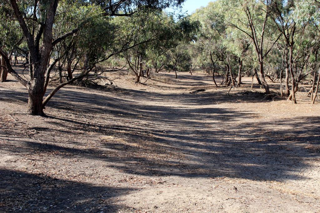
Figure 3: The faint channel of Kinypanial Creek at the end of summer. Photograph by P. Davies.
Byerley was also aggrieved at his treatment because there were numerous precedents for departing from the regulations for laying out pre-emptive rights that had been approved by the minister, including examples involving enclosure of both sides of a creek. After his Boort survey in 1857, for example, Byerley had marked off a pre-emptive section for Rev. William Hall on his Glenalbyn run, located further south of Boort near Inglewood. This 480-acre section enclosed both sides of the ephemeral Kingower Creek to include Hall’s improvements, and the survey was approved.[34] The situation prompted Acting Surveyor-General Clement Hodgkinson to issue a departmental circular in November 1857 demanding strict adherence to the rules, with infringements to be corrected at the surveyor’s expense.[35] The circular, however, made no mention of preventing occupation of both sides of a watercourse, while the 1847 Order in Council clearly forbade it. This put surveyors like Byerley in an awkward position, uncertain if they should follow the strict letter of the law or continue with the informal practice of including both sides of highly ephemeral, indistinct creeks in pre-emptive freeholds.
The committee then called Surveyor-General Charles Whybrow Ligar as a witness. Ligar was born in Ceylon in 1811 and worked on the British Ordnance Survey in Ireland as a young man before his appointment as surveyor-general of New Zealand in 1841. Later, he went to Otago, hoping to acquire land and gain the post of provincial surveyor, but he made numerous enemies in the process.[36] In his History of Otago, AH McLintock described Ligar as ‘a pompous and … shallow’ man.[37] Ligar subsequently came to Victoria and was appointed surveyor-general in March 1858.[38] He had an unsavoury reputation as an opportunist who exploited his position to engage in dubious business practices. He invested heavily in livestock and land, including a lease of 3 million acres in the Riverina, and, in 1862, he reserved land along the Goulburn River adjacent to property he owned, hoping to benefit from an increase in river traffic.[39] Ligar’s heavy-handed suspension of Frederick Byerley on 16 April 1858 occurred after only two weeks in the job as surveyor-general, and may have been an early attempt to assert his authority in the new position.
Ligar based his views and actions on the opinions of others, admitting that the closest he had been to Boort was Bendigo, more than 100 kilometres away. He acknowledged that surveyors of pre-emptive rights carried only general letters of instruction rather than detailed directives to allow them discretion and judgement in individual circumstances. Ligar insisted that, even though Kinypanial Creek was very faint, covered with vegetation and almost indistinguishable from the surrounding land, it was nevertheless ‘a natural watercourse’ that provided the only permanent water for a wide distance around Boort. He denied that the Godfreys’ dam had modified the creek terminus into a pond and claimed that such improvements gave no right to exclusive use or access. Frederick Byerley was, he maintained, wrong to include both sides of the creek in the Godfreys’ freehold.[40]
Charles Ligar relied heavily upon the views of departmental surveyors William Swan Urquhart and Clement Hodgkinson. Urquhart had worked in central Victoria for many years and was familiar with its landscapes, although his only visit to Boort had been a few weeks earlier when water levels were high. He believed the Godfreys’ dam, which was actually underwater within the flooded lake at the time of his visit, was ‘perfectly useless’ for water storage and that Kinypanial Creek remained in its natural state. Byerley, in his view, was in error.[41] Clement Hodgkinson was a career public servant who worked for many years administering Victoria’s land laws. He was appointed acting surveyor-general in October 1857 and deputy to the surveyor-general, Charles Ligar, in March 1858.[42] Hodgkinson had paid a brief visit to Boort a week or two before the committee sat when water levels were still high. He concluded that the terminal reach of Kinypanial Creek at the lake was simply ‘an elongated lagoon’ and thus a natural feature that should have formed a property boundary. He also conceded, however, that numerous pre-emptive plans had been resurveyed in previous years to deal with water frontage issues, where the surveyor had not been dismissed. Nevertheless, he insisted that Byerley had shown ‘a very great want of judgment’ and, as a district surveyor, he deserved severe censure including dismissal.[43]
Despite this opposition to his actions and character, Byerley had numerous supporters. John Hunter Kerr wrote to him in April 1858, advising that Kinypanial Creek was highly unreliable, even with the channel linking it to the Loddon River.[44] Henry Godfrey stressed that he was entitled to ‘the dam, woolshed, and huts’ in his pre-emptive right at Boort and that negative views of Mr Byerley’s character were entirely unjustified.[45] Four witnesses also testified before the select committee on Byerley’s integrity and honour, including physician and scientist Dr Godfrey Howitt and naval officer Captain John Greenlaw Foxton.[46] Alexander Skene was the district surveyor at Geelong and had supervised Byerley’s work in the district for several years previously. Skene came to be one of the most respected and influential public servants in Victoria, eventually succeeding Charles Ligar as surveyor-general in 1869.[47] He reported on Byerley’s survey and found that the dam was a ‘material improvement’ that the Godfreys were entitled to have included in their pre-emptive freehold. The dam turned the lower part of the creek into ‘an artificial pond’, meaning it was no longer a watercourse within the meaning of the regulations, and thus Byerley’s actions were correct.[48]
The select committee reported on 10 February 1859 and found in Byerley’s favour by a 4:3 majority. The report concluded that Byerley:
- had produced an accurate survey of the Boort pre-emptive right
- had received excessive punishment
- had been dismissed without justification
- was a gentleman of strict integrity and honour
- should be reappointed and compensated.
However, there is no evidence that Byerley regained his position in the department. Instead, he became a contract surveyor in Victoria and New South Wales, before moving to Rockhampton in Queensland in 1861 where he worked as a land surveyor and agent, and later as a road engineer. In 1867 he edited the journal of Frank and Alexander Jardine on their 1864 overland expedition from Rockhampton to Cape York. He also published a slim volume on the principles of water supply and construction.[49] He married Constantia Paterson in Victoria in 1877 and died in Queensland on 15 March 1897.
Contesting land and water
The Byerley case occurred during a time of ‘wrangling and disorder’ in Victoria, as the surging gold rush population demanded access to land, water, minerals and other natural resources.[50] By the early 1850s most of the productive land in the Port Phillip region was still controlled by around 800 squatters.[51] The result was widespread political agitation and popular demand for land reform, especially among gold diggers seeking their own rural property. The Eureka rebellion in 1854 was driven in part by the ‘land grievance’ of miners denied the opportunity to purchase and farm their own land.[52] In 1857, the Land Convention sought to abolish existing pastoral occupation and establish selection before survey to ‘unlock the lands’.[53] Yet, it was the squatters and surveyors who understood most clearly the environmental possibilities and limits that the northern plains held for white settlers.
Most disputes over pastoral runs related to overlapping, indistinct and contested boundaries, with commissioners appointed in the early 1850s to resolve disputes between squatters.[54] However, as we have seen, the case of Frederick Byerley was a dispute between a government surveyor and the department for which he worked. It was a study in ambiguities and uncertainties, reflecting colonisers’ imperfect knowledge of northern Victoria’s physical landscapes at the time. The 1847 Order in Council on squatting runs specified that only one side of a watercourse could be included in pre-emptive freeholds, thus forming a property boundary. The departmental circular issued by Clement Hodgkinson in November 1857, however, made no mention of this condition. Surveyors in turn were provided with general guidelines on pre-emptive rights but no detailed instructions. Their task was to interpret land laws and frontage rules and create property boundaries, despite the uncertainty of how these should apply in the physical conditions of Victoria’s northern plains. As Byerley observed to the select committee, ‘circumstances alter cases’.[55]
The crux of Byerley’s case was whether Kinypanial Creek was still in its original condition or if alterations had made it an artificial water body. If the lower part of the creek was simply an ‘elongated lagoon’, and thus natural, it was subject to the frontage regulations and could not be enclosed on both sides in a pre-emptive freehold. If this was the case, then Byerley had been mistaken in his survey. Alternatively, if the creek had become an artificial pond created by the Godfreys’ interventions, it was no longer a natural watercourse but rather an ‘improvement’ they could include in their pre-emptive right, which would mean that Byerley was correct.
Protagonists and antagonists in the Byerley case wanted clarity but the landscape would not provide it. An ‘elongated lagoon’ along a stream was clearly natural, but in this case the stream itself was elusive. It was fed by floodwaters, not springs, and was frequently dry. Its ephemeral character was evident to anyone who knew the country because its course was ‘full of flooded gums which perfectly proves that it has been dry for many seasons’.[56] It was ‘easily ridden over without being traceable’, and ‘any person … would ride over it, and take no notice of it’.[57] Just as importantly for pastoralists, it was a poor boundary, ‘the stream being no fence for cattle or horses, being fordable in all places’.[58] Charles Ligar, resident less than a year in this dry country, saw firm lines on Byerley’s map and looked for a familiar water-filled creek. Long-term colonists were more wary and asked: ‘Is water that disappears to be considered permanent?’[59] How could something with no water be considered a watercourse, and thus a boundary?
There was also uncertainty about the status of Lake Boort, with those involved in the case calling it variously a lake, a swamp or a marsh. The natural filling and drying of ephemeral wetlands like Boort rendered them ambiguous features of the landscape, neither entirely land nor fully water. The ebb and flow of swamp margins made them, like ephemeral creeks, uncertain land boundaries. It was difficult to impose a Western property and farming system on such a fluctuating waterbody.[60] The Crown often ignored the natural function of wetlands and expected them to be either drained for agriculture or filled with water as lakes.[61] Smaller wetlands were retained for water supply in dry regions or where the cost of improvement appeared unjustified. These areas remained unreserved Crown land.
Witnesses at the Byerley select committee were at pains to explain the country to distant authorities in Melbourne, some of them newcomers to the colony who had never visited Boort or had seen it only in wet years. The ‘lake’ itself was not really a lake but a ‘gum swamp heavily timbered with large trees’ where sheep grazed in dry years.[62] The creek was only a line marked on the map. On the ground at Boort it was a line of red gums that was no barrier to livestock and no reliable source of water. When there was water in the creek there was water everywhere and fencing off the lagoon would not prevent others from gaining access.
The riparian tradition of frontages and water access derived from the ‘wet country’ landscapes of the United Kingdom,[63] but this did not always translate well to the much drier conditions of inland Australia. Waterbodies were often highly ephemeral, with flowing creeks and winter swamps drying out in summer. In places where a stream flowed clear and strong, the waterway provided an obvious boundary marker, but when a creek rarely flowed and was only a faint depression in a floodplain, it was much less certain how to apply the rules of land, water and property. Pastoralists built a range of channels, levees and weirs on creeks, rivers, swamps and billabongs, trying to modify water flows to their advantage. Deliberate alterations to natural flows did not necessarily make these watercourses permanent, however, only less ephemeral. Their status as waterbodies remained ambivalent, simultaneously both natural and artificial, temporary and permanent, improved and unimproved. Frederick Byerley was one of those caught in the marginal space between fixed, old-world expectations and the unknown rhythms of an unfamiliar land.
Endnotes
[1] Alfred W Crosby, Ecological imperialism: the biological expansion of Europe, 900–1900, Cambridge University Press, Cambridge, 1986. See also James Belich, Replenishing the earth: the settler revolution and the rise of the Anglo-world, 1783–1939, Oxford University Press, Oxford, 2009; Andro Linklater, Measuring America, HarperCollins, London, 2002; Andro Linklater, Owning the earth: the transforming history of land ownership, Bloomsbury, London, 2013; Joseph M Powell, The public lands of Australia Felix: settlement and land appraisal in Victoria 1834–1891, Oxford University Press, Melbourne, 1970; Simon Winchester, Land: how the hunger for ownership shaped the modern world, William Collins, London, 2021
[2] Linklater, Measuring America, p. xix.
[3] The corollary to settler possession is the dispossession of Aboriginal people. For early discussions of this see Paul Carter, The road to Botany Bay, Faber and Faber, London, 1987; Denis Byrne & Maria Nugent, Mapping attachment: a spatial approach to Aboriginal post-contact heritage, Department of Conservation and Environment NSW, Sydney, 1989.
[4] Matt Edgeworth, Fluid pasts: archaeology of flow, Bloomsbury, London, 2011.
[5] Defining rivers and river channels for legal purposes remains contested between lawyers, geomorphologists and land developers (see e.g. Mark Patrick Taylor & Robert Stokes, ‘When is a river not a river? Consideration of the legal definition of a river for geomorphologists practising in New South Wales, Australia’, Australian Geographer, vol. 36, no. 2, 2005, pp. 183–200; Elizabeth Lamaro, Robert Stokes & Mark Patrick Taylor, ‘Riverbanks and the law: the arbitrary nature of river boundaries in New South Wales’, Environmentalist, vol. 27, 2007, pp. 131–142.
[6] Phillippa Nelson & Lesley Alves, Lands guide. A guide to finding records of Crown land at Public Record Office Victoria, Public Record Office Victoria, Melbourne, p. 143; Order in Council, 9 March 1847, Chapter II, Section 6. Powell notes, however, that La Trobe refused to issue the 14-year leases, opposing the interests of powerful pastoralists. See Powell, The public lands of Australia Felix, p. 27.
[7] Order in Council, 9 March 1847, Chapter II, Section 7.
[8] PROV, VA 2878, Crown Lands Department, VPRS 5359, Pastoral Run Files 1840–1878, Boort Run, 9 January 1854; PROV, VA 2878, VPRS 8168, Historic Plan Collection, P0002, GF14, Line of Old Road from Torpichen Korong Goldfields to Boort, Hugh Frazer, 10 May 1856; PROV, VA 2878, VPRS 8168, Historic Plan Collection, P0007, PR: L41: Boort: Lake Boort, Frederick Byerley, 12 October 1857; PROV, VA 538, Department of Crown Lands and Survey, VPRS 8168, Historic Plan Collection, P0002, Run 11; Boort, RH Shakespear, September 1863.
[9] Yung Balug and their kin continued to live alongside Lake Boort and Kinypanial Creek for many years after the Godfreys’ surveys enclosed their Country. Boort Station served as an Honorary Correspondent Supply Depot in the 1860s and 1870s and Yung Balug also lived at John Hunter Kerr’s Fernihurst Station into the 1860s. See Andrew Long & Ian D Clark, Victorian Honorary Correspondent Supply Depots: a preliminary historical and archaeological investigation, Andew Long and Associates Heritage Matters Pty for Aboriginal Affairs Victoria, Melbourne, 1999; Elizabeth Willis, ‘People undergoing great change: John Hunter Kerr’s photographs of Indigenous people at Fernyhurst [sic], Victoria’, La Trobe Journal, vol. 76, 2005, pp. 49–73. Yung Balug people today maintain an ongoing connection to Country at Boort. Their responsibility to care for and heal Country has been acknowledged in a Recognition and Settlement Agreement and they are working to restore natural flows of water to Kinypanial Creek and Lake Boort. A more detailed discussion of water on Yung Balug Country is the subject of a separate paper being co-authored with Yung Balug people.
[10] Iain M Stuart, ‘The surveyor’s lot: making landscapes in New South Wales’, Australasian Historical Archaeology, vol. 25, 2007, pp. 43–55; Raymond Wright, The bureaucrats’ domain: space and the public interest in Victoria, 1836–84, Oxford University Press, Melbourne, 1989.
[11] The Boort region is a borderland between the granite ranges of the Great Dividing Range to the south, the riverine plains of northern Victoria to the east, the shallow lakes and floodplains of the Murray River corridor to the north, and the sandy soils and rolling dunes of the Mallee to west. For a discussion of the history of white settlement in the Mallee proper, see Richard Broome, Charles Fahey, Andrea Gaynor & Katie Holmes, Mallee country: land, people, history, Monash University Press, Melbourne, 2019.
[12] PROV, VA 2878, Crown Lands Department, VPRS 5359, Pastoral Run Files 1840–1878, Boort Run, 9 January 1854.
[13] ‘Return to address: Mr. Fawkner—8th June 1855’, Crown land licenses, Parliament of Victoria, Melbourne, 1856, p. 54.
[14] PROV, VA 538, Department of Crown Lands and Survey, VPRS 8168, Historic Plan Collection, P0002, Run 11; Boort, RH Shakespear, September 1863.
[15] ‘Mount Hope’, Leader, 3 October 1874, p. 7d-e.
[16] RV Billis & AS Kenyon, Pastoral pioneers of Port Phillip, Macmillan and Company, Melbourne, 1974, p. 157; Paul Haw & Margaret Munro, Footprints across the Loddon Plains. A shared history, Boort Development Incorporated, Boort, Vic, 2010, pp. 279–304.
[17] Haw & Munro, Footprints, p. 298.
[18] Report from the Select Committee upon Mr Frederick Byerley’s Case, Together with the Proceedings of the Committee, Minutes of Evidence and Appendices, Parliament of Victoria, Melbourne, 1858–59, p. 30.
[19] Thomas L Mitchell, Three expeditions into the interior of eastern Australia; with descriptions of the recently explored region of Australia Felix, and of the present colony of New South Wales, Volume II, facsimile of second edition (1839), Libraries Board of South Australia, Adelaide, 1965, p. 153.
[20] Peter Beveridge, The Aborigines of Victoria & Riverina, Lowden Publishing Co., Melbourne, 2008, pp. 89–91.
[21] PROV, VPRS 5359, Pastoral Run Files, Boort Run, 11 January 1855.
[22] PROV, VA 2878, VPRS 8168, Historic Plan Collection, P0002, GF14, Line of Old Road from Torpichen Korong Goldfields to Boort, 10 May 1856; Haw & Munro, Footprints, p. 285.
[23] ‘ad medium filum aquae’, see Sandford D Clark, ‘Australian water law—an historical and analytical background’, PhD thesis, University of Melbourne, 1971, pp. 60–63.
[24] Select Committee on Frederick Byerley’s Case, Appendix A, p. i
[25] Select Committee on Frederick Byerley’s Case, p. 9.
[26] Frederick J Byerley, Statement of Mr. Byerley’s case, W Fairfax & Co., Melbourne, 1858; Eileen Chanin, Book life: the life and times of David Scott Mitchell, Australian Scholarly, Melbourne, 2011, p. 218.
[27] ‘The Survey Department’, Age, 24 September 1858, p. 6d; ‘Parliamentary intelligence’, Argus, 30 October 1858, p. 7a-b.
[28] A Gross, ‘Snodgrass, Peter (1817–1867)’, in Australian dictionary of biography, vol. 2, Melbourne University Press, Melbourne, 1967, p. 455; ‘The dismissal of Mr. Byerley’, Proceedings of the Legislative Council and Assembly of Victoria, Session III, 1858–1859, 14 October 1858, p. 41.
[29] Registrar-General’s Office, Statistics of the colony of Victoria for the year 1857, Parliament of Victoria, Melbourne, 1858–59, pp. 60–62; Wright, The bureaucrats’ domain, p. 80.
[30] Registrar-General’s Office, Statistics of the colony of Victoria for the year 1858, Parliament of Victoria, Melbourne, 1859, p. 49.
[31] Return of surveyors’ field work in 1857, Parliament of Victoria, Melbourne, 1857–58, p. 4.
[32] ‘Mr William John Wills’, Age, 13 November 1861, p. 5e.
[33] Select Committee on Frederick Byerley’s Case, pp. 1–4.
[34] Ibid., p. 4; PROV, VPRS 8168, Historic Plan Collection, P0002, Run 1343; Glenalbyn; Byerley.
[35] Select Committee on Frederick Byerley’s Case, Appendix A, p. ii.
[36] Joseph M Powell, ‘Ligar, Charles Whybrow (1811–1881)’, in Australian dictionary of biography, vol. 5, Melbourne University Press, Melbourne, 1974, pp. 85–86.
[37] AH McLintock, The history of Otago, Whitcombe and Tombs, Dunedin, 1949, p. 400.
[38] Victoria government gazette, vol. 43, 30 March 1858, p. 605.
[39] Wright, The bureaucrats’ domain, p. 130.
[40] Select Committee on Frederick Byerley’s Case, pp. 8–16.
[41] Ken James, ‘The surveying career of William Swan Urquhart, 1845–1864’, Provenance: The Journal of Public Record Office Victoria, vol. 8, 2009; Select Committee on Frederick Byerley’s Case, p. 40.
[42] HW Nunn, ‘Hodgkinson, Clement (1818–1893)’, in Australian dictionary of biography, vol. 4, Melbourne University Press, Melbourne, 1972, pp. 403–404; Wright, The bureaucrats’ domain, pp. 99-211.
[43] Select Committee on Frederick Byerley’s Case, p. 20.
[44] Ibid., Appendix A, p. iii.
[45] Ibid., p. 34.
[46] Mary H Walker, ‘Howitt, Godfrey (1800–1873)’, in Australian dictionary of biography, vol. 4, Melbourne University Press, Melbourne, 1972, pp. 435–436; DB Waterson, ‘Foxton, Justin Fox Greenlaw (1849–1916)’, in Australian dictionary of biography, vol. 8, Melbourne University Press, Melbourne, 1972, pp. 569–570.
[47] Joseph M Powell, ‘Skene, Alexander John (1820–1894)’, in Australian dictionary of biography, vol. 6, Melbourne University Press, Melbourne, 1976, pp. 131–132.
[48] Select Committee on Frederick Byerley’s Case, p. 29.
[49] Frederick J Byerley, Narrative of the overland expedition of the messrs. Jardine, from Rockhampton to Cape York, Northern Queensland, JW Buxton, Brisbane, 1867; Frederick J Byerley, Notes on water supply, and the principles of construction of water works, Gordon and Gotch, Brisbane, n.d.
[50] Powell, The public lands of Australia Felix, p. 51.
[51] The squatters’ directory, containing a list of all the occupants of Crown lands, in the intermediate and unsettled districts of Port Phillip, Edward Wilson, Melbourne, 1849; ‘Return to address: Mr. Fawkner—8th June 1855’.
[52] Gold Fields’ Commission of Enquiry, Report of the Commission Appointed to Enquire into the Condition of the Gold Fields of Victoria, Parliament of Victoria, Melbourne, pp. xiv–xix.
[53] Powell, The public lands of Australia Felix, pp. 66–67.
[54] RV Billis & AS Kenyon, Pastoral pioneers of Port Phillip, Stockland Press, Melbourne, 1974, p. vii
[55] Select Committee on Frederick Byerley’s Case, p. 6.
[56] Ibid., p. 7.
[57] Ibid., pp. 2, 17.
[58] Ibid., p. 2.
[59] Ibid., p. 43.
[60] Kylie Carman-Brown, Following the water: environmental history and the hydrological cycle in colonial Gippsland, Australia, 1838–1900, ANU Press, Canberra, 2019, p. 193; Rod Giblett, Postmodern wetlands: culture, history, ecology, Edinburgh University Press, Edinburgh, 1996, p. 4.
[61] Peter Cabena, Victoria’s water frontage reserves: an historical review and resource appreciation, Department of Crown Lands and Survey, Melbourne, 1983, p. 47.
[62] Select Committee on Frederick Byerley’s Case, pp. 3, 5, 32.
[63] Michael Cathcart, The water dreamers: the remarkable history of our dry continent, Text, Melbourne, p. 259.
Material in the Public Record Office Victoria archival collection contains words and descriptions that reflect attitudes and government policies at different times which may be insensitive and upsetting
Aboriginal and Torres Strait Islander Peoples should be aware the collection and website may contain images, voices and names of deceased persons.
PROV provides advice to researchers wishing to access, publish or re-use records about Aboriginal Peoples