
Author: Kate Follington
The Commissioner's photo collection
In 1877 twelve commissioners were given responsibility to manage, develop and improve the Port of Melbourne. They were known as The Harbour Trust Commissioners and expected to represent the various interests along the Birrarung | Yarra River and Port Melbourne. They ultimately oversaw the transformation of the river into Australia’s largest cargo port, now managing almost 40 per cent of all trade.
A digitised collection of images collected by these commissioners over a century is available online in the series called Photographic Collection 1880 - 1976 VPRS 8357, and it is the largest of several photographic series now in the care of PROV.
There are over five thousand images, including sketches, focused on documenting major public works, marine vessels that ploughed the waterways, or projects which significantly changed the natural landscape and course of the lower Yarra River.
Let's look at the Port of Melbourne through the decades.
1870s Birrarung sandbar
A giant sandbar and narrow channel at the mouth of Birrarung (Yarra River) meant only smaller vessels could transfer goods from Williamstown or Sandridge (Port Melbourne) upstream to Queens Wharf until the 1880s. Go to the Photograph [225] file to download.

1880s Paddle steamers and Coode's Canal
Shortly after the Harbour Trust Commissioners were appointed, the immense task of constructing Coode’s Canal began. By 1886 it connected the Yarra River to Hobson’s Bay directly, bypassing Fisherman's Bend and reducing the travel distance by 3km. Go to the Photograph [256] file to download.

Paddle steamer tugs could manoeuvre more easily up the shallow stretches of the river. The Gannett was owned by the Harbour Trust and escorted the official guests up the Coode Canal during the opening ceremony in 1886. Go to the Photograph [008] file to download.

1890s Victoria Dock
With easier access upstream, longer wharves soon decorated the Yarra’s edge servicing a variety of industries, but for international vessels Victoria Dock was built in 1892 to berth 21 ships. It became the principal international trading wharf for decades and is the largest surviving timber wharf in the world. Go to the Photograph [206] file to download.

1900s Prince's Pier
Prince's Pier in Port Melbourne was built around 1914 to connect ship passengers to the Port Melbourne railway line. Similar to Station Pier nearby, these piers serviced Melbourne’s human cargo, the final wharf for weary ocean travelers returning home or beginning a new chapter in their lives. Go to the Photograph [042] file to download.

1920s Bay steamers
If you were a lucky member of the leisure class in the 1920s and ’30s you likely caught either the Hygeia or Weeroona paddle steamers from Port Melbourne to the Mornington Peninsula. These iconic paddle steamers with saloons and barbers cruised the bay between the wars. Go to the Photograph [039] file to download.

1940s Random cargo
Random cargo was traditionally loaded with nets and cranes. Bales of premium wool or sacks of grain would be wrapped in rope to traverse the rough seas. The United Kingdom bought all of Australia’s wool exports during the Second World War, so by 1950, Australia had earned its reputation as having the best wool in the world. Go to the Photograph [023] file to download.

1950s Station Pier
Station Pier in Port Melbourne welcomed thousands of new European migrants from 1947 until the 1960s. By 1955 Australia had welcomed a million migrants. The mighty Aurelia navigated oceans from Europe bringing with her thousands of (mostly Italians) seeking work in Australia. Go to the Photograph [027] file to download.

1960s Container ships and Swanson Dock
Finally random cargo size gave way to uniform containers off loaded at either end, transforming international shipping trade. In the late 1960s the Melbourne Harbour Trust foresaw this opportunity and built Swanson Dock across a wetland. Almost a kilometre long it remains the largest container terminal in Australia and pivotal to the supply chain system of the Australian economy. Go to the Photograph [004] file to download.

1970s Cruising for fun
By 1970 new Australians tended to arrive by air, so travelling by boat became a holiday destination instead. Ships were redesigned to offer on-board entertainment, P&O cruise liners began berthing at Station Pier in Port Melbourne and disembarking passengers looked for entertainment close by. Go to the Photograph [022] file to download.

1983 World Trade Centre
In the late 1970s the Melbourne Harbour Trust became the Port Authority and they were given the green light to build a World Trade Centre on the Yarra River as a space to foster global trade. It opened in 1983, and perhaps, it is more likely the brutalist architecture than a centre for trade relations, which is its lasting legacy. Go to the Photograph [029] file to download.

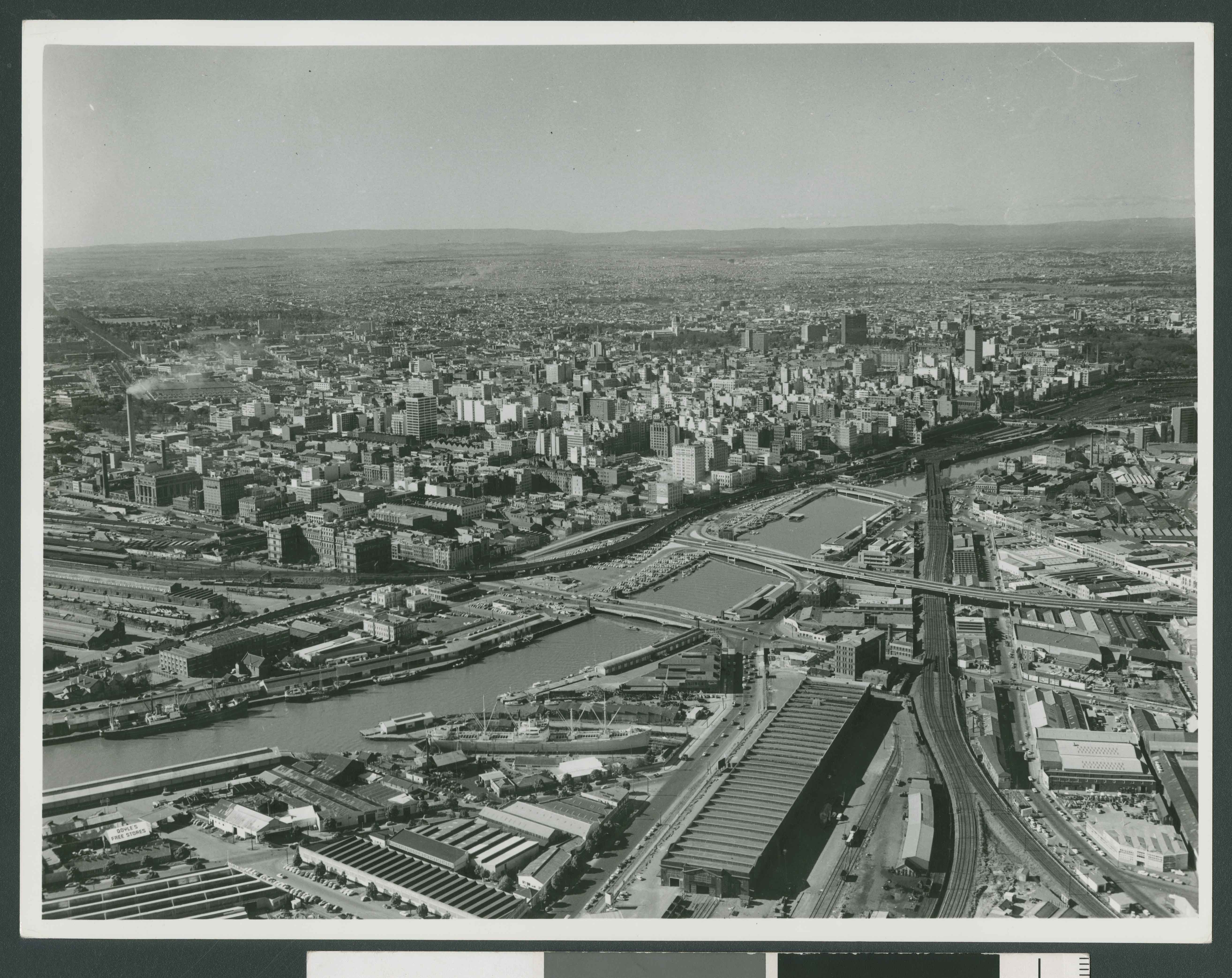
Aerial views
The commissioner's photographic collection also includes a significant number of aerial views of the port and of the city in the later decades of the 20th Century before the development of Southbank. Go to the Photograph [009] file to download.
To explore this collection in more detail, search directly within the series 8357, or search on the main catalogue search field and filter by online to view digitised images.
Material in the Public Record Office Victoria archival collection contains words and descriptions that reflect attitudes and government policies at different times which may be insensitive and upsetting
Aboriginal and Torres Strait Islander Peoples should be aware the collection and website may contain images, voices and names of deceased persons.
PROV provides advice to researchers wishing to access, publish or re-use records about Aboriginal Peoples