Last updated:
‘A Stroll Along the Merri: Evoking a landscape through archival research’, Provenance: The Journal of Public Record Office Victoria, issue no. 6, 2007. ISSN 1832-2522. Copyright © Abigail Belfrage.
Archives held at Public Record Office Victoria, complemented by photography and digital recordings, can provide a rich source of material for evoking a cultural landscape. Similarly, considering records in the geographical context of the landscape they are created in or refer to can enable a greater understanding of the overall context of their creation. A case study of a portion of the Merri Creek in Northcote and Brunswick explores these relationships and some of the stories that can be told about the Merri.
I love a walk along the Merri Creek. The section of the Merri from Rushall Station to Arthurton Road is an area I know well from my many wanders and train journeys, and I cross the Merri every day while riding to work. To the interested eye the landscape of the Merri is rich with layers of evidence of human activity, in the form of buildings, parks, exposed basalt banks, plantings and pylons, prompting questions about the who, when, how and why of these places and features. Walking along the creek makes me wonder about the kinds of records and sources that could answer these questions. Conversely, this piece is intended to show how archives, in this case records created by state and local government agencies, can evoke a landscape, and enable stories to be told about places.
As well as exploring the relationship between the records and landscape of the Merri in words, I will be presenting digitised images of records referring to particular places on the stretch of the Merri we will be ‘walking along’. Each of these will provide occasions for reflection on the connection between records and the place they document. In addition, I will include audio of sound recordings from the Merri that can be accessed via hyperlinks along the way.[1] This piece is not an attempt to write a history of the Merri, nor of the suburbs along its banks. It is primarily a journey through records as a way of exploring a landscape, and vice versa, an exploration of records by journeying through a particular landscape.
This project has been inspired not just from my thoughts and questions about the processes and people that have shaped and inhabited the Merri, but by theoretical discussions about the relationships between cultural heritage institutions such as archives and museums, and their surrounding locales.[2] These theoretical perspectives articulate the profound connection between records and objects and the places they describe or in which they were created. Through the relationships that connect a particular place, in this case the Merri Creek, to a range of contexts, it is possible to evoke a richer range of meanings of both the records and the places to which they relate. The meanings of both the records and the place can inform each other and possibly generate new historical understandings or insights.
There are a variety of contexts for records in addition to the geographic location of their subject matter, including the provenance of their creation, that is, the actual workplace or home in which they were created, or the activity they document. As we read about the places described in the records, and through the records uncover layers of meaning in the landscape, we can also to a lesser extent, by placing ourselves in the landscape physically or even imaginatively, consider layers of meaning and context in the records, and the processes and people that created them.
There are many kinds of sources alongside public records that are capable of providing insights into life along the Merri, such as newspapers, reports, published and unpublished histories, photographs, as well as a variety of web sites and web-based resources such as databases. Public records have been selected for this piece for their ability to communicate about human experience and processes of change along the Merri, and how the records combined and described are able to communicate a sense of the landscape. As a case study it is intended that this piece can point the way to sources, particularly records held at Public Record Office Victoria, for people interested in researching and writing about landscapes and their historical, cultural and social dimensions. I have also drawn on discussions with people about their associations with places along the Merri, and included sound recordings and photographs taken along its banks.
Setting the Scene
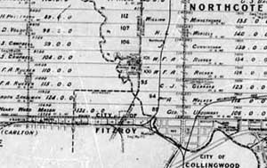
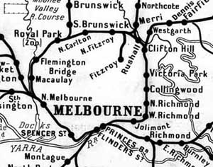
The Merri Creek is the border between Northcote and its southern and western neighbours in Clifton Hill, North Fitzroy and Brunswick. I will be taking you on a stroll along its banks and through some of the records about the Merri held at Public Record Office Victoria. We will meander northwards along a small area of the Merri starting at Rushall Station in North Fitzroy and continuing as far as the site of the old quarries by the Arthurton Road Bridge. We will be exploring how people have experienced and shaped the Merri over the last two centuries, and how we can learn about these processes from the landscape and places along it, and from records about the Merri. As we will discover, a large number of state and colonial government departments have created records about this area of creek, mainly to do with the creation and maintenance of institutions and infrastructure along its banks.
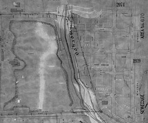
PROV, Parish Plans on Microfiche, Parish of Jika Jika, Fiche No. 944.
This excerpt from the parish plan of Jika Jika shows the allotments and names of the grantees of Crown land around the Merri up to 1927, when this version of the parish plan was last updated. The Merri winds its way south to join the Yarra, functioning as the border for some of the allotments, and the suburbs of Northcote and Brunswick, and Northcote and (North) Fitzroy. Some distinctive features are apparent at this point: the public land on the border of the creek in the middle of the parish plan, and the way St Georges Road and the railway line cross the Merri in the south. The dates on the plan illustrate the main periods of survey and occupation of the land surrounding the Merri by non-Indigenous people. Note also the smaller subdivisions at the southern end of the plan, indicating where the township of Westgarth grew near the Merri Creek.
Railway line from Rushall Station to Merri Station
This stretch of railway from Rushall to Merri station as it crosses the creek is a remarkable, if not iconic feature of the Merri landscape, and a significant piece of infrastructure in the growth of Northcote and the inner northern suburbs of Melbourne.
This portion of the railway line ran from Clifton Hill to Northcote station, connecting the Inner Circle to the Northcote-Preston-Whittlesea line, also known as the Fitzroy and Whittlesea line. It took several decades to bring plans for this connection to fruition.
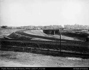
PROV, VPRS 12800/P1 Photographic Collection, Railway Negatives, Alpha-numeric Systems, H2158 .
Proposals were held up by disputes between rival councils (Fitzroy and Collingwood) and the economic depression of the 1890s. Now part of the Epping line, the Northcote Loop, as this curve in the line was often called, was completed in 1904.[3]
As a passenger on a train today, winding around the curve, the landscape of the Merri and its surrounds unfolds almost as a theme park. As the train wheels scrape the tracks, a soundtrack is formed to accompany the panorama. The wheels’ low notes echo along the creek banks, the rhythm section rattles out a beat and harmonics whistle across the valley against the western face of the Northcote (Ruckers) hill, especially at night after the traffic has disappeared, a rumbling screeching sound.
Yan Yean Water Mains Pipe
Whether we’re walking north along the creek from Rushall station or travelling on the train, two large pipes crossing the creek soon come into sight. They are ugly pieces of metal on first impression, but become less brutal as you get to know them. One of the neighbourhood’s best kept engineering secrets, this pipe is listed on Victoria’s Heritage Inventory due to its historical significance as a piece of the state’s water infrastructure.[4]
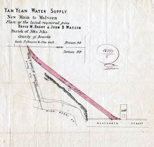
Excerpt from PROV, VPRS 8609/P28, Unit 3, 1876, Correspondence between the Commissioners and landowners Barry and Watson.
The line from the Yan Yean Reservoir to Melbourne was built between 1853 and 1857 as part of Melbourne’s first major water supply project. Additional mains were constructed as the demand for water grew.[5] While most of the land used to lay the pipe, or associated access tracks, was Crown land, tracts of private land such as the one shown above were acquired prior to construction.
Merri Primary School
Another 200 metres downstream from the Yan Yean pipes, and still in North Fitzroy, is Merri Primary School. Formerly known as State School 3110 and then Miller Street Primary School, it sits up on the North Fitzroy bank of the Merri by the St Georges Road bridge. Constructed in 1891 by the Public Works Department, the original two-storey building is handsome in the blood and bandage style of brickwork. The building has undergone significant additions and alterations since it was built. The school grew to meet the needs of a changing student body and community. An example of some of the effort involved in adapting a school building is illustrated by a look into the Public Works Department Capital Works files in the early 1970s.[6] A page from this file records the process of approval for a fairly basic work, the installation of linoleum for a classroom. The page is almost an artwork of twenty stamps of approval, revealing the sometimes painstaking process of negotiating with a government department.
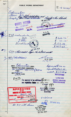
PROV, VPRS 6039/R1 Major Works Project Files, Unit 20, File No. C141686 C.
With its layers of structures, its banks and bush, and shallow flows, the Merri Creek along this stretch was and is a place for these students to roam (out of school hours), as Normie Rowe, a former Merri Primary student remembers:
The Merri Bridge I crossed each day to get to school, and the [Yan Yean] pipe next to it, where we’d dare each other to cross, 300ft drop, no safety net. The same under the scaffold-like substructure of the 500ft high rail bridge between Merri and Rushall stations.
Of course, the Merri Creek, where I believe fish have started swimming once again — when I was a kid the only living things there were the big blue/black yabbies, disease and water rats as big as bull-terriers.[7]
Northcote High School and the Northcote Inebriate Asylum
Taking the track beside Merri Primary School upstream for 300 metres we can see on the opposite bank the football fields of Northcote High School and its school buildings fronting onto St Georges Road. No doubt many students from State School 3110 would have graduated to the High School. What was it like moving to the big school upstream from Merri Primary? Normie Rowe, reflecting on this transition, remembers, ‘Something went wrong when I got to Northcote High School. I think it was called Rock n’ Roll’.
The high school was opened in 1929 after lobbying by the five surrounding local councils for another secondary school during the mid-1920s.[8] A deputation from the Northcote council met the Minister of Education in September 1920 to put forward their case for a new elementary school. They argued that Northcote’s population needed greater educational opportunities as its population was developing at a rapid pace, and would increase when the local railway lines were electrified.[9] A couple of days before Christmas, 1927 (and a few inches of archives later), the Minister authorised the Public Works Department to call for tenders for a new school building for Northcote High School on its present site.[10] These records offer an insight into some of the aspirations of a growing community, working to establish opportunities and infrastructure for the next generation.
It is interesting to consider whether many teachers and students over the years at Northcote High School would have known that it was built on the site of the Northcote Inebriate Asylum, also known as the Northcote Inebriate Retreat. Presumably it was once common local knowledge. However, significant time elapsed between the Asylum’s closure in early 1892[11] and the opening of Northcote High School on the site in 1929.
The Northcote Inebriate Asylum was a private organisation opened in 1873 housing small numbers of women who were more or less sentenced to treatment there.[12] It became a government operation in 1890 as announced by a notice in the Government Gazette:
The Asylum for Inebriates, at Northcote, is now open for the reception of a limited number of female patients who are unable to contribute towards their maintenance.
Applications on behalf of or from persons requiring treatment in this institution should be made to Dr. McCarthy, the Supt. of the Asylum, from whom all necessary information can be obtained.[13]
A snapshot of the Inebriate Asylum’s inmates, in the form of an admissions register, is held by PROV.[14] Covering the period from 1890 to 1892, the register recorded basic facts about their circumstances. From these entries we can re-create the demographics at the Retreat for those three years.
In 1890 there were only four admissions, one of those being a readmission. In 1891 there was an increase in the number of residents with fifteen admissions. More information about the residents was recorded in entries made this year. Nine of the women were married, with two widows and four single women. Only six women were born in Australia (three in Melbourne and three in country Victoria), while the rest were from New Zealand, Ireland, Scotland and England. Six belonged to the Church of England, five were Presbyterians and there were four Roman Catholics. Nine were described as having chronic alcoholism, and one lady as having ‘morphinism’ (morphine addiction). Entries in the register in 1892 showed a similar breakdown of background and conditions, made up of twenty-one admissions. Some were readmitted from previous years.
It would be interesting to learn more about the lives of these women and how they passed their time on the banks of the Merri. How much contact might they have had with the local communities of Northcote, Westgarth, North Fitzroy or Brunswick? What was life like in the Inebriate Asylum? In contrast with records that relate to the other two institutions along the Merri, the primary and secondary school, which communicate a sense of growth and connection with the local community, the Inebriate Asylum records depict quite a different sense, as it was made up of individuals drawn from outside the local area, who probably had little or no connection with the surrounding community. The Asylum building is no longer there and the register offers little opportunity for insight into the inmates’ experiences, but the questions remain.
Back to Northcote High School and another building by the creek; in my father’s time as an English and Latin teacher at Northcote High School in the early 1960s, teachers would drop in to the Albion Charles Family Hotel, downstream from the high school, for a quiet one at the end of the week. From the hotel front bar they could see the creek across Merri Parade and the St Georges Road bridge, and if they looked a bit further, they’d see Merri Primary School.[15] From the pub it was a short stroll to Merri station, or just a few steps to catch the St Georges Road tram home.
With its grounds located on the banks of the creek, the Merri has been a presence for the students and staff of Northcote High School. One former student remembers that in the 1990s students would frequent its banks at lunch time and after school (no doubt against school rules), and roam the storm water tunnels that empty into the Merri in the southern corner of the school grounds.[16]
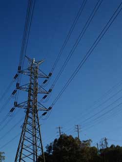
Pylons
As we journey further downstream and cross the creek at a footbridge at the end of the school grounds we are struck by one of the most significant visual features along the creek; a chain of electric pylons. On windy days you can hear their wires gently whistling. In February 1974 the State Electricity Commission of Victoria (SEC) received permission from the Department of Crown Lands and Survey to reinstall the existing 66kV pylons and create a new line of much bigger pylons capable of carrying 220kV of electricity. This line would ‘provide for future power requirements in the northern inner metropolitan area’ by connecting the Brunswick Terminal Station with the Clifton Hill Terminal Station. As part of the arduous process of planning for the lines, the SEC had to gain approval from four additional jurisdictions, including the Northcote City Council, Melbourne Metropolitan Board of Works, Fitzroy City Council and Victorian Railways.[17]
Considerable debate was taking place over the proposal to install the pylons, due to their size and visual impact on the Yarra and Merri valleys. A number of organisations were campaigning against the installation, including the Merri Yarra Municipal Protection Committee, which represented eight municipal councils from adjoining areas to the proposed line, and members of the Yarra Bend Park Trust and Studley Park Association. In a 1983 report provided to the Minister of Ethnic Affairs, the Committee stated their concerns about the impact of the power lines and their aspirations for the Merri and Yarra valleys in this area:
For the first time, a modest but concerted effort is being made to clean up river banks and to create access to the inner urban Merri Creek and Yarra Valley with reforming of banks, planting, creation of cycle tracks and the like. For the first time in more than a century, there seems to be the promise of giving back industrialised and despoiled stretches of the Merri Creek and Yarra to the people.
… The proposed new power lines and associated towers will, in the view of the committee, invade the park in a real and physical way. It is not just a visual threat, but a real loss of parklands … People who would most use these parks are from the above inner suburbs and, in the main, live cheek by jowl with industry and high rise accommodation. They are people who can least afford to lose the valuable asset of open land for recreation.[18]
Photograph Abigail Belfrage March 2007.
Quarries
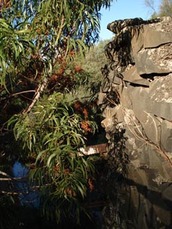
The banks of the Merri are geologically distinctive. The naked eye can see evidence of mineral flows cooling from volcanoes, and other enormous forces capable of creating layers and patterns in the exposed rock. In stretches along the creek the flow has cut its way through steep banks of basalt and bluestone. Humans have cut and carted away even more. Now a place resonant with recreation and regeneration, the creek between the Arthurton Road bridge and the Yarra was for a time an ants nest of activity with its many quarries.
Individuals could apply to the Department of Crown Lands and Survey for a quarrying licence, such as Mr Benjamin Tapner who in 11 August 1859 requested No.6 quarry in lieu of No.4 ‘as there is no stone on it’. His request was granted.[19] Mining companies also extracted stone from the Merri’s banks, notably the Albion Quarrying Company Limited, which operated from March 1885 to April 1893, and from July 1912 to May 1970[20], and its subsidiary the Merri Creek Quarry Proprietary Limited, which operated from January 1927 until its liquidation in June 1966.[21]
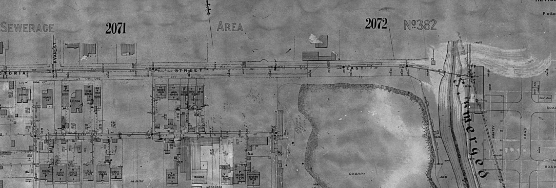
Excerpt from PROV, VPRS 8601/P2, Unit 5, Plan No. 1938, last revised 1915.
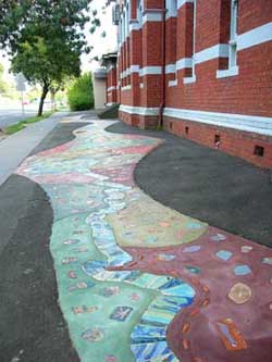
If we continue walking along the western bank of the creek we pass the Brunswick Terminal Station (electricity) on the left and approach a viewing platform to our right. Overlooking the creek and adjacent to the platform are the remains of a bluestone winch holder, once part of Wales’ Quarry which was operated by the Albion and Merri Creek quarrying companies. A glimpse of the landscape as a working quarry can be gleaned from this Melbourne Metropolitan Board of Works (MMBW) Detail Plan, last revised in 1915.[22]
Photograph Abigail Belfrage March 2007.
The outline of the quarry and the spreading waters of the creek at the end of Victoria, Kirkdale and Albert Streets is starkly visible. On the Northcote side of the creek (the side opposite the viewing platform) is a sprawling MMBW depot, another site of human industry. Interpretive signs and a sculpture near the viewing platform describe the workings of the winch in the quarry, evoking images of the gutted creek as an industrial site, a world away from its revegetated banks today.
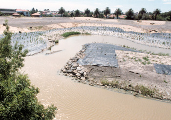
PROV, VPRS 8662/P1, Unit 8, Image 13.
The work carried out on the replanting of the Merri’s banks since the 1980s changed the landscape once again, and created a home once again for birds and other wildlife. A stage in this process of reinvention is captured in a photograph taken by the Melbourne and Metropolitan Board of Works which depicts the first replanting of the Merri in the early 1980s on the site of their old depot.[23] These records document, and thereby assist us to re-imagine, the industrial activity of the quarry, its return to bare reconstructed ground, and then to revegetated and reconstructed banks once it ceased being a quarry.
There are many more places to explore, records to investigate and stories that can be told about the Merri and the people who have lived along its banks. For those of you familiar with this stretch of creek I hope this excursion through records and sound has brought it to life and evoked some of the people, debates and processes that have shaped the landscape; the early non-Indigenous land allocation patterns, the emergence of infrastructure in the form of railway lines, water mains and electricity pylons, the establishment of institutions (a primary and secondary school and an inebriate asylum), and the Merri as a place of geological significance, industry and recreation before, during and after its time as a quarry.
Whether or not you are familiar with this landscape I hope that this stroll along the Merri has provided a good example of the kind of exploration of a landscape that can be undertaken through records, stories and sound. I hope I have also demonstrated how, by considering records in the context of the landscape to which they refer, our understanding of the records’ content is enriched. My research into the Merri has changed the flavour of my journeys along the Merri and I notice more features in the landscape that formerly blended into the general ambience of the creek. While this archival research has answered some of my questions, more have emerged as I have encountered the records, pointing me towards further research, walks and stories.
More sounds of the Merri
Endnotes
[1] You will need to be online to access these sound files, which are in MP3 format. Alternatively, you could download them onto your computer and listen to them while you are reading a printed copy of the article. All sound recordings were taken in the Merri study area in September 2007. Minor editing has been undertaken to improve sound quality, apart from the last track listed at the end of the article ‘Merri suburban mix’ which is a blend of sounds sampled from these field recordings. Thanks to Jaye Hayes for technical advice and sound editing.
[2] H Taylor, ‘”Heritage” revisited: documents as artifacts in the context of museums and material culture’, Archivaria, Fall, 1995, no. 40, pp. 8-20; and P Davis, ‘Places, “cultural touchstones” and the ecomuseum’ in G Corsane (ed.), Heritage, museums and galleries: an introductory reader, Routledge, London, 2005, pp. 365-77.
[3] A Lemon, The Northcote side of the river, Hargreen, North Melbourne, 1983, pp. 137-8. Andrew Waugh, pers com, April 2007. See his website for details of railway history and railway maps: http://www.vrhistory.com/VRMaps/.
[4] H7822-0060, Yarra City, Heritage Inventory AHC Type 6.3.1 Water supply and irrigation. From Heritage Register and Inventory, viewed online 4 April 2007: http://www.heritage.vic.gov.au/page_239.asp?ID=239.
[5] T Dingle & H Doyle, Yan Yean: a history of Melbourne’s early water supply, Public Record Office Victoria and Melbourne Water, Melbourne, 2003.
[6] PROV, VA 669 Public Works Department, VPRS 6039/R1 Major Works Project Files, Unit 20, File No. C141686 C.
[7] Merri Primary School, From Miller St to Merri Primary ‘The best years of your life‘: the first hundred years at Merri State School 3110, 1891-1991, 1991, p. 46.
[8] LJ Blake, Vision and realisation: a centenary history of state education in Victoria, vol. 2, Department of Education, Melbourne, p. 222.
[9] Notes of Deputation from the Northcote Council which waited on the Minister (Mr W Hutchinson MLA) to urge the establishment of a high school at Northcote, PROV, VA 714 Education Department, VPRS 3916/P0 Building Files: High Schools, Unit 116, 27 October 1920.
[10] Covering note on school building file, PROV, VA 714 Education Department, VPRS 3916/P0 Building Files: High Schools, Unit 116, 23 December 1927.
[11] Notice in Government Gazette, Melbourne, 20 September 1892, p. 3706, https://www.landata.vic.gov.au (viewed online June 2007).
[12] Lemon, The Northcote side of the river, p. 128; entry on PROV’s online catalogue for VA 2853 Northcote Inebriate Asylum, http://access.prov.vic.gov.au (viewed online June 2007).
[13] Notice in Government Gazette, Melbourne, 24 July 1890, p. 3045, https://www.landata.vic.gov.au (viewed online June 2007).
[14] PROV, VA 2853 Northcote Inebriate Asylum, VPRS 7478/P0 Register of Admissions, Unit 1.
[15] Noel Belfrage, English and Latin teacher at Northcote High School 1960–1964, pers com January 2007.
[16] Former student, pers com, April 2007.
[17] PROV, VA 538 Department of Crown Lands and Survey, VPRS 11794/P1 General Correspondence Files, ‘M’ Series, Unit 78, Corr. No. G73404, Jika Jika, State Electricity Commission of Victoria.
[18] PROV, VA 1029 Victorian Multicultural Commission, VPRS 11790/P1 General Correspondence Files, Annual Single Number System, Unit 204, File No. 83/1819 Merri Creek/Yarra Valley Transmission Lines, MYMPC Report – 15/9/1983, From Councillor PA Joes, City of Hawthorn and Chairman of the MYMPC, p. 9.
[19] PROV, VA 538 Department of Crown Lands and Survey, VPRS 6605/P0 Chief Commissioner of Crown Lands Inward Correspondence, Unit 28, Item 59/1520.
[20] PROV, VA 538 Office of the Registrar-General and the Office of Titles, VPRS 932/P0 Trading Company Registration Files, Unit 54, company no. 903, and Unit 269, company no. 5131.
[21] PROV, VA 538 Office of the Registrar-General and the Office of Titles, VPRS 932/P0 Trading Company Registration Files, Unit 716, company no. 12284. The date ranges cited for the duration of mining companies does not imply that quarrying was carried out along the banks of the Merri throughout this period.
[22] PROV, VA 1007 Melbourne and Metropolitan Board of Works, VPRS 8601/P2 Detailed Base Plans [DP] 40’=1' Numeric, Unit 5, Plan No. 1938, last revised 1915.
[23] PROV, VA 1007 Melbourne and Metropolitan Board of Works, VPRS 8662/P1 Photographic Images (Positives, Prints), Unit 8, Photograph no. 13.
Material in the Public Record Office Victoria archival collection contains words and descriptions that reflect attitudes and government policies at different times which may be insensitive and upsetting
Aboriginal and Torres Strait Islander Peoples should be aware the collection and website may contain images, voices and names of deceased persons.
PROV provides advice to researchers wishing to access, publish or re-use records about Aboriginal Peoples