![Great Western Hotel, Temple Court Hotel and Assay Office in a detail taken from the PROV version of the Bibbs map, VPRS 8168/P3 Historic Plan Collection, Unit 46, MELBRL 12 Melbourne: [Melbourne. n.d.].](/sites/default/files/files/MinchintonB-F05_banner_0.jpg "Great Western Hotel, Temple Court Hotel and Assay Office in a detail taken from the PROV version of the Bibbs map, VPRS 8168/P3 Historic Plan Collection, Unit 46, MELBRL 12 Melbourne: [Melbourne. n.d.].")
Last updated:
‘The Bibbs map: who made it, when and why? ’, Provenance: The Journal of Public Record Office Victoria, issue no. 18, 2020. ISSN 1832-2522. Copyright © Barbara Minchinton.
This is a peer reviewed article.
The Bibbs map is employed by Melbourne’s urban archaeologists to decode the remains of the city’s gold rush era building fabric, but it has been dated differently by different researchers. There are two known copies of the plan in existence, one held by Public Record Office Victoria (PROV) and the other by the Melbourne City Council. This article argues that the two maps were produced at different times for different purposes, but the survey on which they were based was completed in the first half of 1856 in order to facilitate the implementation of Melbourne’s reticulated water supply. The plan is one of a number in the Historic Plan Collection at PROV providing valuable background information for heritage research.
Melbourne’s urban archaeologists love the nineteenth-century Bibbs map (Figure 1). It not only sets out where buildings were located at a particular point in Melbourne’s rapid gold rush development, but also colour-codes their building materials, representing iron buildings, for example, in rich blue.
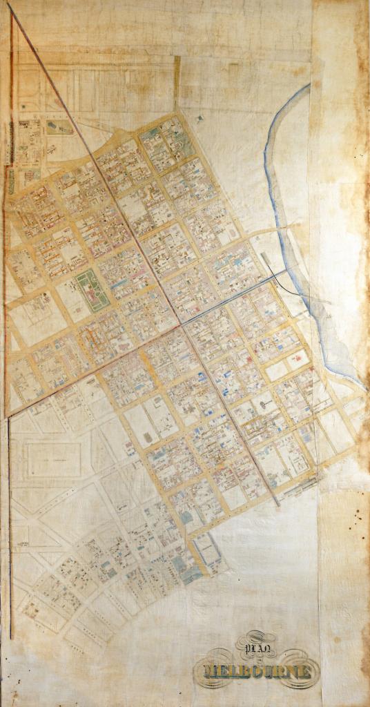
Figure 1: ‘Bibbs map—a cadastral map of Melbourne, c. 1854’, City Collection, City of Melbourne, available at <http://citycollection.melbourne.vic.gov.au/bibbs-map-a-cadastral-map-of-melbourne/>, accessed 19 October 2020.
Archaeological investigations conducted on areas covered by the Bibbs map have a head start when it comes to interpreting the remains of buildings found on the ground. For this historian, however, the Bibbs map provided as many puzzles as it solved, starting with the question of how to reference it correctly: who surveyed it, when was it made and where was the original located? Other questions followed: why was it called the ‘Bibbs map’, who was Bibbs and why was it made? Answering the last question led to the location of a series of similar maps covering areas surrounding the central city. By setting out the context of the creation of these maps and the process involved in dating them, this paper aims to help archaeologists use and interpret the information found on them. The discussion focuses on determining when the survey data represented on the Bibbs map was collected and why, as well as when the physical maps were produced.
What was the purpose of the Bibbs map?
When Melbourne’s household water supply system was being built in the 1850s, the Commission of Sewers and Water Supply needed to determine where to put the standpipes (on every corner) and the stopcocks (outside each dwelling), not to mention where to locate the 1,700 fireplugs and fire hydrants, all of which meant working out how and where to lay the water mains on Melbourne’s streets.[1] Obtaining the measurements that enabled the engineers to specify the required number and length of pipes, stopcocks, fire hydrants and so on meant surveying the entire area where water was to be supplied, including determining the type of building to be connected and its location on the allotment. The survey information used to create the Bibbs map is the result of that process for central Melbourne.
Where is the Bibbs map located?
In his article ‘Maps for building research’, Miles Lewis refers to ‘Thomas Bibb’s [sic] Cadastral Map of Melbourne’ as being ‘held at the PRO’ (Public Record Office, now Public Record Office Victoria, hereafter PROV) with ‘a copy at the Melbourne City Council’.[2] Searching PROV’s records, however, will not produce this map with any mention of the name ‘Bibb’ or ‘Bibbs’, and nor does it appear in the records of the Commission of Sewers and Water Supply.[3] It is actually held as part of what is known as the Melbourne Roll sub-collection within the Historic Plan Collection, and not referred to as ‘Bibbs’ at all: it is MELBRL 12 within Victorian Public Record Series (VPRS) 8168, to be exact, and it is referred to as a plan, not a map, because the series was nominated as part of the Historic Plan Collection by the creating agency. Unlike many of the other plans in the Melbourne Roll, MELBRL 12 is not available online from PROV in a digitised form. Instead, it is only available to the public in black-and-white microfiche form at PROV’s reading room; the original is closed to the public under Section 11 of the Public Records Act 1973 due to its fragility, and its catalogue entry does not attribute it to ‘Bibbs’ or anyone else.[4] So, how is it that so many archaeologists have nice, coloured, digitised versions of it available for use? The answer to that question is an example of the best of collegiate cooperation between Melbourne’s archaeologists.
Back in 2015, archaeologist Geoff Hewitt spent many hours tracking down the elusive Bibbs map at PROV and, having located MELBRL 12 in the PROV catalogue, Natalie Paynter followed it up and confirmed that MELBRL 12 was indeed the Bibbs map mentioned by Lewis. Megan Goulding of Ochre Imprints subsequently paid PROV for a high-quality digitised colour version, which she then generously shared with the profession; at that time, PROV had no facility for making it available to the public on its website.[5] By 2019, the digitised version from Ochre Imprints had become well known in the industry as a standard research tool for Melbourne’s urban archaeologists, but its PROV reference was not included on archaeological documentation. It was simply referred to as ‘the Bibbs map’.[6] PROV has subsequently digitised a selected portion of the Historic Plan Collection (including some of the Melbourne Roll) and made these plans available through its online catalogue, but the Bibbs map is not among them (Figure 2).[7]
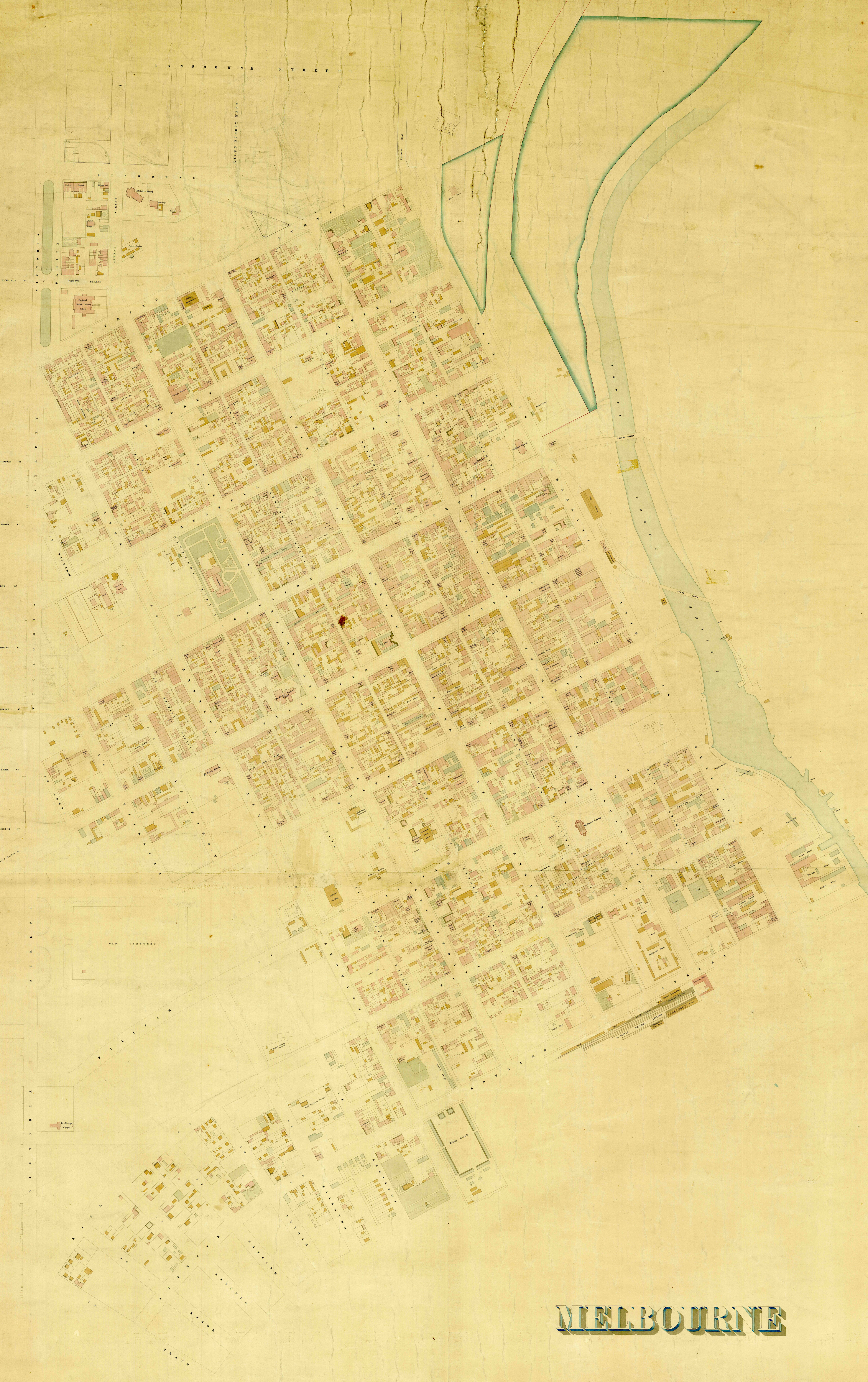
Figure 2: PROV’s version of the Bibbs map, VPRS 8168/P3 Historic Plan Collection, Unit 46, MELBRL 12 Melbourne: [Melbourne. n.d.]. The detailed selections in Figures 3–7 are all taken from this version of the map.
But what of the copy Miles Lewis mentions as being held by the Melbourne City Council (MCC)? A low-resolution image of that ‘copy’ is currently available online,[8] but a comparison of the two maps—PROV’s MELBRL 12 with the MCC ‘Bibb’s [sic] map’ (which, following Lewis’s description, is attributed to ‘Thomas Bibb’)—reveals small but important differences. While it appears that the two maps were drawn from the same underlying survey data, the PROV version is much clearer, and carries many more labels (e.g., on hotels, horse bazaars and small streets). The MCC version is described as ‘pen, ink and watercolour on linen’, while PROV’s map ‘appears to be lithograph colour plate’, ‘mounted on a cloth backing’,[9] which perhaps explains some of the differences in colouring and clarity. The colours are much more consistent on the PROV map, but some of those on the MCC version—especially the blocks of red and blue—are much brighter. The most important difference, however, is the addition on the PROV map of pencilled outlines of some ‘proposed’ buildings. The Treasury, for example (now known as ‘the Old Treasury Building’), does not appear on the MCC plan at all, but it is there on the PROV map accurately outlining its masonry in a later pencilled addition, alongside other roughly pencilled ‘proposed’ buildings (Figure 3).
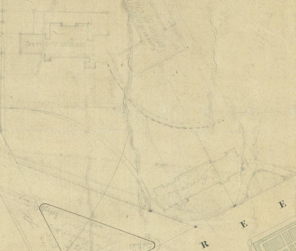
Figure 3: Pencilled outlines of Treasury and proposed offices in a detail taken from the PROV version of the Bibbs map, VPRS 8168/P3 Historic Plan Collection, Unit 46, MELBRL 12 Melbourne: [Melbourne. n.d.].
Who made the Bibbs map? Clement Hodgkinson’s preparatory sketches and other plans
When Melbourne was part of the Colony of New South Wales, surveys were done by officers located in the Port Phillip District, but the plans they drew had to be sent to Sydney for approval. After separation from New South Wales in July 1851 Victoria appointed its own surveyor-general, and the gold rushes of the early 1850s made his department an extremely busy one.[10] Surveys were desperately needed, especially for the remote goldmining areas, but qualified and experienced staff were hard to find and expensive to hire. Early in 1852, Clement Hodgkinson (‘formerly Contract Surveyor in the Sydney District’) was appointed as a draftsman in the Surveyor-General’s Office; by April, he had been recommended as a (temporary) assistant surveyor and, in August, he was ‘placed on Establishment as Assistant Surveyor’.[11] At that time, he was working on a tramline to Melbourne, but soon afterwards he became involved in the planning for Melbourne’s sewerage and water supply.
With the influx of thousands of goldminers, Melbourne’s sanitary state had become a major problem, as had the question of who was responsible for improving it; the Melbourne City Council believed it should be in their bailiwick, and the newly formed Victorian Legislative Council thought it was in theirs.[12] The Legislative Council had the most power and, in 1852, took the initiative away from the MCC by forming a Water Supply and Sewerage Committee. Lieutenant-Governor Charles La Trobe then instructed Clement Hodgkinson to ‘perform such work as may be required for the information of the Committee’, and ordered the surveyor-general to ‘see that [Hodgkinson] is provided with the proper instruments’, and ‘supply such maps &c from your Department as the Committee may deem it nece[s]sary to consult’.[13] So, by the time the Legislative Council set up the Commission of Sewers and Water Supply and appointed its three commissioners on 13 April 1853, Hodgkinson had already completed some of the preliminary planning. A plan he produced, dated 12 April 1853 with the heading ‘Contoured Plan of part of the City of Melbourne Showing the Street Frontages: Melbourne Sanitary Survey Sheet No 1: Working plan of Contours’ is held by PROV in the Melbourne Roll of the Historic Plan Collection as MELBRL 15-1 and is available online.[14] It is another useful tool for Melbourne’s archaeologists because it, too, colour-codes the building materials making up the frontages of buildings at that date. More useful still for some areas is the series of 10 sketches of central Melbourne blocks drawn by Hodgkinson from his surveys in March and April 1853.[15] They are in the same style and colouring as the Bibbs map, and show the full detail of the buildings rather than just the frontages; they are annotated as ‘transmitted to the Commissioners of Sewerage and Water Supply for the City of Melbourne July 9th 1853’, but some are clearly incomplete as though they were sent off in haste for someone else to finish. Hodgkinson’s survey book for the series contains the survey details for the 10 mapped blocks, but the rest are only there in outline.[16]
For all the similarities of style and content, these Hodgkinson plans of 1853 are not the same as the Bibbs map. Melbourne was developing rapidly as a result of the gold rushes and even a few months could make a substantial difference to the number and type of buildings on any particular block, so when the Commission of Sewers and Water Supply appointed its own surveyor, one of his first public actions was to ensure that details of ‘the level or intended levels of the cellar or lowest floor’ and the ‘situation and construction of the privies and cesspools to be built’ in any new buildings were passed on to him through the city surveyor.[17] Thus, details of buildings erected after Hodgkinson’s survey sketches were sent to the commission appear frequently on the Bibbs map and form the basis of more accurate dating (see below).
After submitting his incomplete sketches of central Melbourne to the commissioners of sewers and water supply in July, Hodgkinson went on to create contour maps of Collingwood and Richmond, also showing buildings.[18] By the middle of 1854, he was ‘Surveyor in Charge of the Melbourne Districts’, and other surveyors were being employed to create this kind of map for other areas.[19] These maps are also in the Historic Plan Collection at PROV and most of them have been digitised (Table 1).
Table 1: A list of the maps held in the Historic Plan Collection at PROV that provide information about Melbourne’s building fabric in the 1850s similar to that recorded on the Bibbs map
Historic Plan Collection details
URL
MELBRL 2 ‘Municipal District of East Collingwood shewing Streets Buildings and Enclosures in existence at close of Survey July 1856 … Submitted to … the Surveyor General on Oct 3rd 1856 Clement Hodgkinson’.
MELBRL 2a ‘Plan of the Streets & Buildings of East Collingwood January 1st 1858 … Surveyed &c. by John S. Wilkinson in accordance with Mr Hodgkinsons instructions. Engraved by J.D. Brown’.
MELBRL 2a1 'Plan of the Streets & Buildings in East Collingwood January 1st 1858 … Surveyed &c. by John S. Wilkinson in accordance with Mr Hodgkinsons instructions. Engraved by J.D. Brown’ [Part map only].
MELBRL 2a2 [Streets and Buildings in East Collingwood n.d.].
<https://beta.prov.vic.gov.au/collection/PID2175598008>, <https://beta.prov.vic.gov.au/collection/PID0175598017>, <https://beta.prov.vic.gov.au/collection/PID6174214915>, <https://beta.prov.vic.gov.au/collection/PID8174214906>
MELBRL 2a3 [Streets and Buildings in East Collingwood n.d.].
MELBRL 3-1 ‘Contoured Plan of Collingwood and East Melbourne shewing the Buildings Facing the Principal Streets … Transmitted to the Surveyor General … Novr 29th 1853 Clement Hodgkinson’.
MELBRL 3-2 ‘Contoured Plan of Collingwood and East Melbourne shewing the Buildings Facing the Principal Streets … Transmitted to the Surveyor General … Novr 29th 1853 Clement Hodgkinson'.
MELBRL 4 ‘Emerald Hill … Compiled and drawn by Wm H. Steel … 29 May 1857 [with] Clement Hodgkinson’.
Not yet online. The physical copy is at PROV VPRS 8168 Historic Plan Collection P3 Unit 51.
MELBRL 6 ‘Emerald Hill … Drawn by B. Beckett … under the command of Capt. A. Clarke … 1854’.
Not yet online. The physical copy is at PROV VPRS 8168 Historic Plan Collection P3 Unit 53.
MELBRL 11 [Melbourne Doutta Galla Jika Jika Melbourne North Melbourne South Prahran n.d.] [only shows hotels, churches and other public buildings, with corrected date of 1866 superimposed on one building].
MELBRL 12 [Melbourne. n.d.], [Bibbs Mapp].
Not yet online. The physical copy is at PROV VPRS 8168 Historic Plan Collection P3 Unit 46.
MELBRL 15-1 ‘CONTOURED PLAN OF THE CITY OF MELBOURNE Showing the Street Frontages Transmitted to the Surveyor General with accompanying Report dated April 12th 1853 Clement Hodgkinson Surveyor Jno Debenham Draftsman’.
MELBRL 18 ‘Melbourne and its suburbs [Jika Jika Melbourne North Melbourne South Prahran] … Compiled by James Kearney Draughtsman. Engraved by David Tulloch and James D. Brown, Captain Andrew Clarke, R.E. Surveyor General. 1855’.
MELBRL 18a ‘Melbourne and its suburbs [Jika Jika Melbourne North Melbourne South Prahran] … Compiled by James Kearney Draughtsman. Engraved by David Tulloch and James D. Brown, Captain Andrew Clarke, R.E. Surveyor General. 1855’.
MELBRL 19 ‘Prahran Municipality … Surveyed under the Superintendence of Serjeant Forbes R. S. & M. & Drawn by Horace Samson, … Melbourne April 1856’.
MELBRL 25 ‘Municipality of Richmond Shewing buildings and other details in existence on completion of Survey Sept 1855’.
Not yet online. The physical copy is at PROV VPRS 8168 Historic Plan Collection P3 Unit 49.
MELBRL 28b ‘PLAN OF ST KILDA And the Sea Coast from thence Eastward to the Town Boundary Post on Point Ormond Surveyed & Plotted by Alexander Black July 1854’.
MELBRL 33a [Williamstown; appears to be early sketch of part of MELBRL 34].
MELBRL 34 ‘Williamstown … July 5th/58 G.A. Windsor’.
Dating the survey for the Bibbs map
The digital copy of Bibbs’s map of Melbourne being used by archaeologists today comes from PROV, but it has no date appended. It is clearly the completed version of the plan that Hodgkinson began in 1853, and Miles Lewis dates it at ‘about 1854’.[20] A portion of it is held at State Library Victoria, but there it is dated ‘s.n. 1855’.[21] Archaeologists, however, are inclined to date their digitised map c. 1856 or 1857.[22] Given Melbourne’s rapid development in this era, and the map’s content in terms of buildings and their construction materials, these are wildly divergent dates.
Melbourne was growing at a great rate when Clement Hodgkinson created his first sketch plans for the Commission of Sewers and Water Supply in 1853. The Australian architectural index created by Miles Lewis provides some idea of the pace of building, with the Melbourne entries being based on ‘Intention to Build’ notices lodged with the MCC and information from other sources.[23] While the notices do not guarantee that building took place, and other notices may be missing, overall, the index illustrates the pace of building in the city: searching the keyword ‘Melbourne’ for 1853 produces over 700 entries, many of which were for multiple houses, shops or warehouses.[24] The rate decreased in 1854 to just over 400 entries, again including multiple constructions. By 1860, it had slowed even further, but still produced over 100 entries. Every time a new building was erected in Melbourne, Hodgkinson’s survey became outdated, which affected the engineers’ calculations for the delivery of water. But survey office procedures were designed to allow for updates.
Working plans in the office incorporated alterations until they were too crowded or messy to accommodate more, which is when a new plan was drafted from the old data. These plans were not dated unless they were printed and made available to the public. State Library Victoria holds several versions of a map of the entire County of Bourke ‘compiled by Thomas Bibbs, 1855’.[25] Printed on each map is the information that it was lithographed by William Collis, first in 1856, then with the information ‘corrected up to 1857’, and then with dates up to 1866.[26]
Dating a survey map is, therefore, a tricky business because different sections will have been surveyed at different times. Dating the Bibbs map means beginning with Hodgkinson’s 1853 sketches for the Commission of Sewers and Water Supply (which are clearly dated both for survey and submission), and then adding the information available from other sources regarding new buildings and additions. But first, some information about Bibbs himself.
Who was Bibbs?
Thomas Franklin Bibbs was born in Worcester, England, in 1823. His father was a saddler. By the time of the 1851 census, Thomas had become a ‘Clerk to Com[missioner]s of Sewers’ in London.[27] At the age of 30, he embarked at Liverpool on the Marco Polo and arrived in Melbourne towards the end of May 1853. Five months later, on 1 November, he was appointed as a temporary draftsman in the Surveyor-General’s Department, Melbourne, earning £250 per annum, presumably on the strength of his previous work with sewers.[28] Exactly how ‘temporary’ that first appointment was is not known, but Thomas’s younger brother and cousin arrived in Melbourne in January 1854, and they seem to have travelled about with Thomas, who returned from Sydney on the steamship Waratah in July 1854, suggesting that his first stretch of employment in Melbourne had not been very long.[29] Nevertheless, he was back working in the survey office soon after his return, because he is credited with drawing a ‘map of part of the southern coast of Victoria shewing Port Fairy and Lady Bay’ in August 1854.[30] His employment was frequent if not continuous, since he made a generous donation to the Patriotic Fund while working at the Surveyor-General’s Department in July 1855, and the 1856 St Kilda electoral roll shows him as an employee earning the requisite ‘£100 from government’.[31] In December that year, Bibbs won a gold medal from the Victoria Industrial Society for his plan of Corner Inlet, Bass Strait, and a silver medal for his plan of the Castlemaine and Sandhurst goldfield.[32] He was obviously capable of high-quality work but, unlike Clement Hodgkinson, he remained a draftsman through the 1850s rather than climbing to the rank of surveyor, although he described himself as a ‘civil engineer’ when he became insolvent in 1861.[33] This and other evidence suggests that he had also remained a temporary staff member rather than obtaining a permanent position.[34] On 1 May 1863 he was appointed as a photo-lithographer in the Department of Crown Lands and Survey ‘in consequence of Mr Bibbs’s professional skill, as ascertained in his previous connection with this department’.[35]
Bibbs’s dismissal in 1866 suggests both a cause and an explanation for this intermittent work history. At the request of the surveyor-general, who ‘complains of Mr Bibbs frequent absence from duty’, the chief secretary arranged for the chief medical officer to visit him and ‘report on [the] state of his health’.[36] The report indicated that Bibbs was ‘suffering from results of irregular mode of living’, which was translated in the Executive Council Minutes as ‘charges of intemperance’. As a result, he was dismissed from the public service.[37]
After leaving the survey office, Bibbs created a few maps for commercial publishers, including ‘a very beautiful map of Launceston’ and ‘The excursionists map’ for Whitehead & Co. in the 1870s, but little else is known of his life or creative work.[38] He appears to have moved to New South Wales, where the death of one ‘Thomas Bibbs’ is recorded in 1879.[39]
This outline of Bibbs’s life gives us a framework for plotting the possible dates for the Bibbs map, if indeed it was Bibbs who compiled it. At the earliest, it could have been December 1853 (after he took up his first appointment in the survey office) and, at the latest, 1866 (when he was dismissed), but his appointment as a photo-lithographer in 1863 makes it unlikely that he was creating new survey plans after that date.[40] The pencilled addition of the Treasury Building (begun in 1858 and completed in 1862) and other ‘proposed’ buildings on the PROV version, together with the fact that Melbourne’s water supply from Yan Yean was delivered in December 1857, narrows the dates closer to those suggested by Lewis, State Library Victoria and the archaeologists—that is, between 1854 and 1857.
When was the Bibbs map lithographed?
Given that Clement Hodgkinson’s sketches were submitted to the commissioners of sewers and water supply early in July 1853, and that he moved on to create the same kind of survey for Collingwood before becoming ‘Surveyor in charge of the Melbourne Districts’,[41] it is reasonable to ask whether ‘the Bibbs map’ might have been Bibbs’s first task when he began working at the department on 1 November 1853. The plan itself, however, argues against that date. Examination of the following features provides a more accurate estimate of the date of the surveys represented on the plan.
The foundation stone of St John’s Church, which was located on the corner of Elizabeth and La Trobe streets, was laid on 30 January 1854, and the church was opened on 2 July 1854, although the chancel and nave were not completed until 26 October 1856. Hodgkinson’s 1853 sketches would not have recorded this building even if they had covered this block (they do not), but it does show up on the Bibbs map (Figure 4).[42]
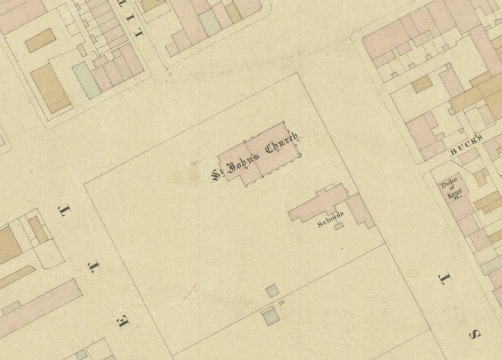
Figure 4: St John’s Church in a detail taken from the PROV version of the Bibbs map, VPRS 8168/P3 Historic Plan Collection, Unit 46, MELBRL 12 Melbourne: [Melbourne. n.d.].
Similarly, in July 1854, Charles Webb called tenders to erect Wesleyan School Rooms; they were opened on 26 December that year, and they too appear on the Bibbs map, but not on Hodgkinson’s plan.[43]
More tellingly, on 7 March 1855 the Age reported that the Great Western and Temple Court hotels, both in Queen Street, applied for new licences, neither of which were granted until 26 April 1855.[44] Both buildings are labelled as hotels on the Bibbs map (Figure 5), suggesting that the survey of that portion of the map at least took place after the middle of 1855, a supposition that is extended by the representation of Coppin’s Olympic Theatre in Lonsdale Street, as building there commenced on 13 April 1855.[45] Even later, the Assay Office, represented on the Bibbs map at 58 Queen Street, was not opened for business until 23 October 1855 (Figure 5).[46]
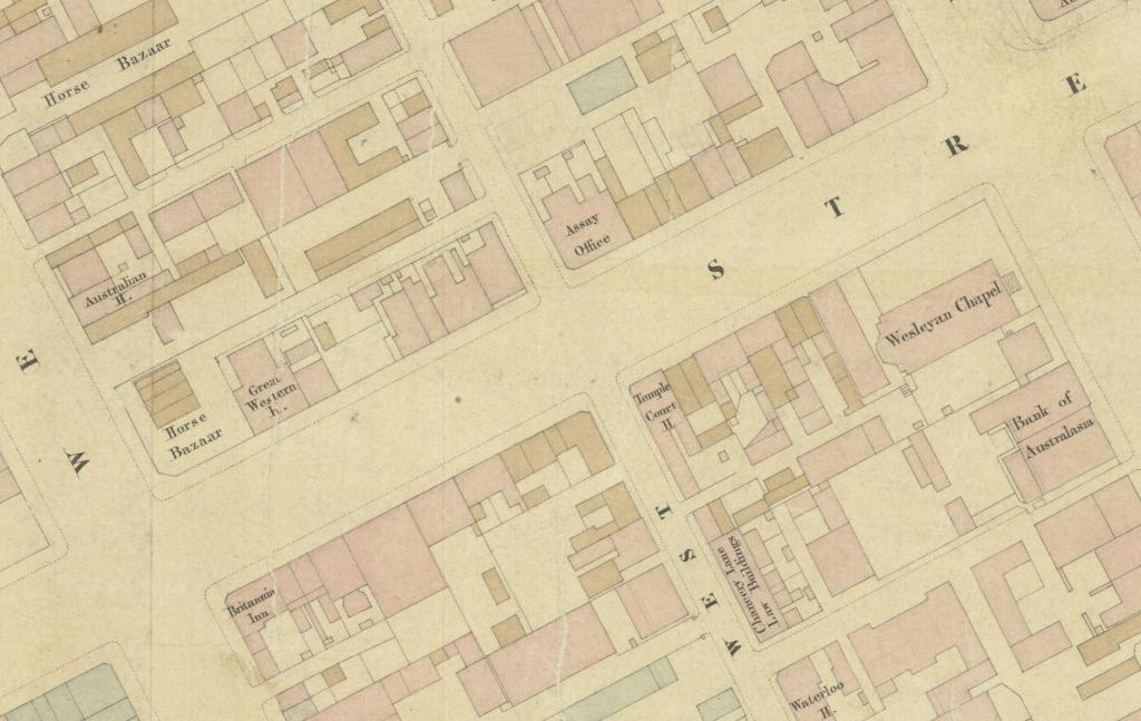
Figure 5: Great Western Hotel, Temple Court Hotel and Assay Office in a detail taken from the PROV version of the Bibbs map, VPRS 8168/P3 Historic Plan Collection, Unit 46, MELBRL 12 Melbourne: [Melbourne. n.d.].
These cases all push the date of survey towards the end of 1855, a date that is confirmed by the presence of the English Scottish & Australian Chartered Bank on the corner of Flinders Lane and Elizabeth Street. Construction there commenced on 4 December 1855 and was ‘nearly complete’ on 25 September 1856. It appears on the Bibbs map, though erroneously labelled the ‘English Scottish and Colonial Bank’, suggesting that it did not have its shingle out when the surveyors drew it (Figure 6).[47]
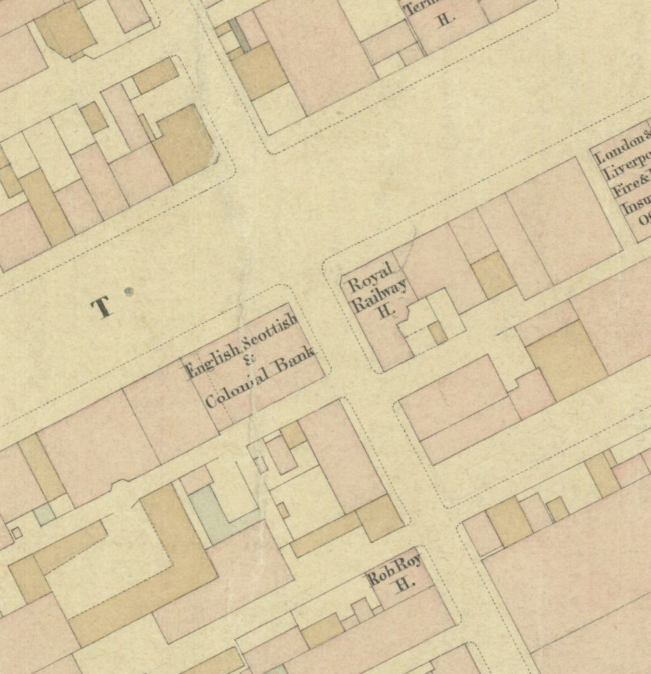
Figure 6: English Scottish and Colonial Bank in a detail taken from the PROV version of the Bibbs map, VPRS 8168/P3 Historic Plan Collection, Unit 46, MELBRL 12 Melbourne: [Melbourne. n.d.].
A decisive piece of the puzzle comes with the construction of the Bank of New South Wales on a vacant block of land on Collins Street across the road from the Criterion Hotel.[48] Building commenced on 29 May 1856 in Collins Street, with further tenders let on 17 July 1856, but this block is still entirely vacant on the Bibbs map (Figure 7),[49] indicating that the survey was completed prior to any building taking place on that block. Other buildings that were begun later in 1856 also do not appear on the Bibbs map.[50]
Figure 7: Vacant block that became the Bank of New South Wales in a detail taken from the PROV version of the Bibbs map, VPRS 8168/P3 Historic Plan Collection, Unit 46, MELBRL 12 Melbourne: [Melbourne. n.d.].
All of this points to a date for the Bibbs map surveys being early to mid-1856—after construction of the English Scottish & Australian Chartered Bank (December 1855), but before building started on the Bank of New South Wales (mid-1856). Given that the incomplete surveys of Hodgkinson’s 10 blocks (out of the 24 making up central Melbourne) were spread from March to June 1853, there is probably little point in attempting to specify the dates of survey for the entire Bibbs plan any closer than ‘the first half of 1856’. This timing fits with the completion of several other maps for the commission, which enabled it to turn the Yan Yean water on for Melbourne in December 1857: MELBRL 25 Richmond, September 1855; MELBRL 2a East Collingwood, January 1856; MELBRL 19 Prahran, April 1856; and MELBRL 2 East Collingwood, July 1856. All of these plans, except that of Prahran, were surveyed by Clement Hodgkinson, although they are not all attributed to him on the plans themselves. Apart from the consistent style of the maps, confirmation of the attribution comes from two lists that were drawn up of the plans located in the Surveyor-General’s Office in 1855 and 1856. These include the name of the surveyor responsible for each plan, and some were specifically recorded as being held in ‘District Surveyor Hodgkinson’s Drawer’.[51]
Did Thomas Franklin Bibbs compile ‘the Bibbs map’?
Unfortunately the 1855 and 1856 lists from the Surveyor-General’s Office do not indicate who the draftsman or lithographer might have been. John Debenham drafted Hodgkinson’s early sketches, and carefully noted his own and Hodgkinson’s names and relevant dates on the plans themselves, but the later maps are not so helpful. No evidence has been found in this research to link Bibbs to any of Hodgkinson’s maps of Melbourne’s streets and buildings for the Commission of Sewerage and Water Supply; however, tying their survey dates in with Bibbs’s employment history does not rule out the connection. The years 1855 and 1856 were successful for Bibbs professionally at the survey office—he won prizes for two plans—but there is a curious inscription on another plan that perhaps explains something about his professional development.[52]
The map drawn by Bibbs that is most commonly found in libraries today is his 1855 map of the County of Bourke.[53] His later maps are usually inscribed ‘TF Bibbs Lithographer’ or something similar, but this early map is quite specific: ‘compiled by Thomas Bibbs, 1855; lithographed by William Collis, 1856’, suggesting that Bibbs was not at that stage qualified or experienced enough to lithograph maps himself. Another common map of his, published in 1859 but compiled and lithographed before that date, is even more specific: ‘Lithographed at the Office of Lands & Survey, Melbourne’, and ‘the outline and hills by Thomas Franklin Bibbs, the writing by William Collis’.[54] It would seem that either the work was large and needed two sets of hands, or Bibbs was only halfway to being a fully competent lithographer, or the lettering was added later (see below). From 1858 onwards, Bibbs was acknowledged as ‘lithographer’. So, while Bibbs certainly drafted (‘compiled’) maps drawn from Clement Hodgkinson’s surveys of the County of Bourke, he would not have been the lithographer on the Melbourne water supply maps of 1856. He may well have drawn the Melbourne City Council copy, however, because it was created later.
On 25 July 1860, the town clerk of Melbourne requested copies of the plans ‘prepared for the Sewerage of the City’ from the government’s Sewerage and Water Department—that is, the plans from which the Bibbs map was compiled. In reply he was told that ‘the City Surveyor can have the tracings required provided he sends a Draftsman for that purpose’.[55] If the MCC had to make its own copy of the sewerage plans, who did it? There are very few maps by Thomas Bibbs that were published in 1860, suggesting that he was not working much with the survey office. Perhaps he was employed by the town clerk for this one-off task and perhaps it was the first time he had done the lettering himself. The Old English font of the title is impressive, it is true, but the building labels are very poor compared to the PROV copy (Figure 8). Bibbs went on to work on a number of maps for the Department of Crown Lands and Survey early in 1861, but he was declared insolvent in November that year due to ‘illness, bad debts and loss of employment’.[56]
Figure 8: A sample of lettering from ‘Bibbs map—a cadastral map of Melbourne, c. 1854’, City Collection, City of Melbourne, available at <http://citycollection.melbourne.vic.gov.au/bibbs-map-a-cadastral-map-of-melbourne/>, accessed 19 October 2020.
The City of Melbourne Art and Heritage Collection attributes its copy of ‘Bibb’s [sic] Plan’ to ‘Thomas Bibb’ on the strength of Miles Lewis’s reference in his 2001 article ‘Maps for building research’.[57] Lewis attributed the work to Bibbs on the basis of his late colleague George Tibbits’s familiarity with it rather than his own research; nevertheless, he believes the attribution is likely to be correct because ‘Bibbs is not a name like Hoddle, which people throw in as a guess’.[58] I am inclined to agree, thinking that perhaps somewhere in the Melbourne City Council archives there exists a contract or document relating to Bibbs’s work on the plan in their possession, but I have not found it.
Whether Bibbs created the map or not, the timing of the surveys underpinning it now seems clear, but there is a proviso. Under the Melbourne Building Act 1849 builders were required to lodge Intention to Build Notices with the city surveyor before commencing construction, and the surveyor for the Commission of Sewerage and Water Supply in turn required that the city surveyor notify him of any new building works, but it is unlikely to have been a foolproof system.[59] It is possible that, on some blocks, buildings may have been built prior to mid-1856 without the required notification, and therefore not recorded on the Bibbs map.
Conclusion
The Bibbs map is well known to Melbourne’s urban archaeologists as a useful tool for decoding the remains of the city’s gold rush era building fabric. It was created to facilitate the implementation of Melbourne’s reticulated water supply from the Yan Yean reservoir, which was turned on in Melbourne at the end of 1857, and it was not the only map of its type to be drawn up. Table 1 provides a list of similar plans in the Historic Plan Collection at PROV that could prove to be of great use to archaeologists working in surrounding suburbs, most of which have now been digitised (available by searching under ‘MELBRL’ on PROV’s catalogue). Importantly, the Bibbs map has been dated differently by different authors. A careful comparison of historical sources with the two known copies of the plan (MELBRL 12 of the Historic Plan Collection at PROV and ‘Bibb’s [sic] map’ in the City of Melbourne Art and Heritage Collection) indicates that the survey on which it was based was completed by Clement Hodgkinson in the first half of 1856. The two Bibbs plans appear to have been put to different uses and to have been produced at different times, with the PROV plan created in time for the laying of water pipes in Melbourne’s streets in 1857–1858 and the Melbourne City Council plan created after July 1860. The PROV plan seems to have remained a working document of the Department of Crown Lands and Survey (hence the pencilled-in updates of major buildings such as the Treasury Building and ‘proposed wings’ on the hospital and government buildings), while the MCC copy is more likely to have been an item for reference or display. It was already outdated by the time of its making.
How to correctly reference the Bibbs map
The full reference to the Bibbs map for archaeologists using the digitised version obtained from PROV by Ochre Imprints is:
MELBRL 12, Public Record Office Victoria, VA 2921 Surveyor-General’s Department VA 943 Surveyor-General’s Department, Port Phillip Branch, VPRS 8168/P3 Historic Plan Collection, Unit 46.
Endnotes
[1] Tony Dingle and Helen Doyle, Yan Yean: a history of Melbourne’s early water supply, Public Record Office, Melbourne, 2003, p. 31.
[2] Miles Lewis, ‘Maps for building research’, LaTrobe Journal, vol. 68, Spring, 2001, p. 22.
[3] The extant records of the Commissioners of Sewers and Water Supply are held at Public Record Office Victoria (PROV), Victorian Agency (VA) 2802 Commissioners of Sewers and Water Supply Victorian Public Record Series (VPRS) 8609 Historical Records Collection. I have consulted P20 Unit 361, P25 Unit 24, P35 Units 220, 273, 520, 869 and 889, P28 Units 12 and 14.
[4] PROV, VPRS 15899 Historic Plan Collection (microfiche copy of VPRS 8168), MELBRL 12; PROV, VPRS 8168 Historic Plan Collection, P3, Unit 46. PROV identifies the plans in VPRS 8168 by reference to the Historic Plan Collection plan number (allocated by the agency that established the collection), a description of the plan and the area to which the plan pertains.
[5] Megan Goulding, personal communication, 7 January 2020.
[6] For example, Figure 6, Qu.A.C. Archaeology and Heritage, ‘229-241 Franklin Street, Melbourne (H7822-2042)’, Archaeological Excavation Report, Heritage Victoria report 4760, 2018, p. 12; Figure 7, ArchLink, ‘Langlands Iron Foundry and Stookes Shipping Butchers H7822-1847’, Historical archaeology excavation report, [2015], p. 16.
[7] The digitised maps can be found online on PROV’s website in VPRS 8168, various consignments. The digital image scan of the Bibbs map held by PROV will soon be made available online through its catalogue after the implementation of new systems that will facilitate the online publishing of many other digital scans of records in the PROV collection.
[8] ‘Bibbs map—a cadastral map of Melbourne, c. 1854’, City Collection, City of Melbourne, available at <http://citycollection.melbourne.vic.gov.au/bibbs-map-a-cadastral-map-of-melbourne/>, accessed 19 October 2020. A high resolution copy was made available to the author by Cressida Goddard, Art and Heritage Collection Administrator City of Melbourne, 15 January 2020.
[9] Notes on the plan from Charlie Farrugia, Senior Collection Adviser, PROV, provided to the author 19 December 2019.
[10] Robert Hoddle was Victoria’s first surveyor-general until 1853. He was followed by Andrew Clarke (1853–1858). PROV, VA 2921, Surveyor-General’s Department covers the period until 1857.
[11] PROV, VPRS 6/P0, Surveyor-General’s Department Outward Letter Books, Unit 4, 52/5, 6 January 1852, p. 65; 52/126, 5 April 1852, p. 110; 52/215, 3 August 1852, p. 140.
[12] Dingle and Doyle, Yan Yean, pp. 6–7.
[13] Colonial Secretary to Surveyor-General, 18 September 1852, PROV, VPRS 1258/P0, Surveyor-General Inwards Correspondence, Unit 1, bundle 2, 1852–1853. Hodgkinson described this period as being ‘when my professional services were lent to the Board of Commissioners by the Government’, ‘Water supply to Melbourne’, Argus, 7 June 1854, p. 5.
[14] A list of all map links can be found in Table 1.
[15] PROV, VA 2802 Commissioners of Sewers and Water Supply, VPRS 8609/P35 Historical Records Collection, Unit 520. The blocks represented in these surveys were Queen/Lonsdale/Elizabeth/Bourke streets, Bourke/Queen/Collins/William streets, Bourke /Queen/Collins/Elizabeth streets, Swanston/Bourke/Russell/Collins streets, Collins/Russell/Flinders/Swanston streets, Collins/William/Queen/Flinders streets, Collins/William/Flinders/King streets, King/Lonsdale/William/Bourke streets, Russell/Lonsdale/Stephen/Bourke streets and Queen/Lonsdale/William/Little Bourke streets.
[16] PROV, VA Surveyor-General’s Department, VPRS 16685/P1 Surveyors’ Field Books, Black Sequence, Unit 12, item 77, Book 1141 [Survey Book 1141, Bundle 77].
[17] Banner (Melbourne), 24 January 1854, p. 13.
[18] ‘The Legislative Council’, Argus, 7 September 1853, p. 4. See Table 1: MELBRL 2 ‘Municipal District of East Collingwood close of survey July 1856’; MELBRL 2a ‘Plan of the streets and buildings in East Collingwood January 1st 1856’; MELBRL 2a2 ‘Plan of the streets and buildings in East Collingwood January 1st 1856’; MELBRL 25 ‘Municipality of Richmond shewing buildings and other details in existence on completion of survey September 1855’; and MELBRL 3 ‘Contoured plan of Collingwood and East Melbourne 29 November 1853’.
[19] See Table 1: MELBRL 4 ‘Emerald Hill, Wm H Street [with assistance from Clement Hodgkinson], 29 May 1857’; MELBRL 6 ‘Emerald Hill, B Beckett, 1854’; MELBRL 19 ‘Prahran, Serjeant [sic] Forbes, April 1856’; MELBRL 28a and 28b ‘St Kilda, Alexander Black, 1854’; MELBRL 34 Williamstown, A Windsor, 5 July 1858.
[20] ‘Thomas Bibb’s [sic] Cadastral Map of Melbourne’, cited in Lewis, ‘Maps for building research’, p. 21.
[21] [City blocks bounded by Collins, Lonsdale, King and Queen streets, by TF Bibbs] Melbourne, State Library Victoria, MAPS 821.09 EH 1855? BIBBS.
[22] Melbourne CBD south post excavation stage 3 preliminary land use history v.1, Melbourne, Ochre Imprints Pty Ltd, p. 1; Figure 7, ArchLink, ‘Langlands iron foundry and Stookes Shipping butchers H7822-1847’, Historical archaeology excavation report, [2015], p. 16.
[23] Miles Lewis, Australian architectural index, available at <https://aai.app.unimelb.edu.au/apex/f?p=199:11:::NO>, accessed 17 January 2020; PROV, VA 511 Melbourne (Town 1842–1847; City 1847-ct), VPRS 9288 Notices of Intention to Build. The index includes the Burchett index of MCC Notices of Intention to Build, together with information extracted from newspapers such as the Argus and journals such as Australian Builder, so the number of actual buildings constructed is necessarily imprecise.
[24] These figures are confined to Melbourne, excluding East Melbourne, West Melbourne and North Melbourne.
[25] For example, ‘County of Bourke’, [Melbourne], Surveyor General’s Department, [1857?], State Library Victoria, MAPS 821.1 BJE 1857.
[26] See State Library Victoria collection. The map was published by the Surveyor-General’s Department, then FF Bailliere, then the Department of Crown Lands and Survey.
[27] 1851, England Census, St Anne Soho, Co Middlesex, Westminster, household schedule 49 Piece 1510, Folio 527, p. 10.
[28] PROV, VPRS 6/P0, Surveyor-General’s Department Outward Letter Books, Unit 4, A53/439, 29 November 1853, p. 335; Colonial Secretary to Surveyor-General, 14 December 1853, PROV, VPRS 1258/P0 Surveyor-General Inwards Correspondence, Unit 1, bundle 2, 1852–1853, 53/817.
[29] Benjamin and Frederick Bibbs arrived on the Marco Polo, PROV, VPRS 947 Unassisted Inward Passenger Lists. For their return from Sydney, see Victoria Coastal Passenger lists 1852–1924, listed incorrectly under ‘Worotag’, available at <findmypast.com.au>, accessed 22 January 2020. His younger brother Frederick John Bibbs was killed by a fall from a cart near Castlemaine, see ‘The late Mr Bibbs’, Mount Alexander Mail, 6 February 1861, p. 2.
[30] ‘Drawn by Thomas Bibbs, August 1854’, Surveyor-General’s Office, Melbourne, 1854, State Library Victoria, MAPS 825.56 A 1854 BIBBS (2 copies).
[31] Victoria Government Gazette, no. 69, 20 July 1855, p. 1669; Victoria Electoral Roll, St Kilda Division, 1856, p. 19.
[32] ‘Victoria Industrial Society’, Age, 12 December 1856, p. 3.
[33] ‘New insolvents’, Age, 20 November 1861, p. 7.
[34] For example, on 26 November 1856 he returned from Sydney on the Yarra Yarra and in August–September 1859 he went to Launceston. See Victoria Coastal Passenger lists 1852–1924, available at <findmypast.com.au>, accessed 22 January 2020.
[35] Victoria Government Gazette, no. 51, 20 May 1863, p. 1098.
[36] PROV, VPRS 3993/P0 Chief Secretary’s Department Register of Inward Correspondence II, Unit 9, p. 216 no. 5307.
[37] PROV, VA 2903 Executive Council, VPRS 1080/P0, Minutes of the Executive Council, Unit 9, 66/59 10 September 1866, p. 532; ‘The Gazette’, Australasian, 29 September 1866, p. 20.
[38] ‘Map of Launceston’, Cornwell Chronicle (Launceston), 31 December 1870, p. 8. ‘The excursionist’s map’, Trove, available at <https://nla.gov.au/nla.obj-450281697/view?searchTerm=Bibbs#search/Bibbs>, accessed 12 March 2020.
[39] Thomas Bibbs, NSW Registry of Births, Deaths and Marriages, Death 1122/1879. Note, this record has not been sighted to confirm whether it is Thomas Franklin Bibbs.
[40] Curiously, there is a map entitled ‘Special allotments, Parish of Beechworth’ at State Library Victoria ‘lithographed at the Department of Lands & Survey, July 19th 1867 T F Bibbs’. Presumably, after losing his permanent position, he continued to do some contract work.
[41] See Table 1, MELBRL 3 Collingwood and East Melbourne 1853; ‘Lynch versus Murphy’, Argus, 22 May 1854, p. 5.
[42] Lewis, Australian architectural index, record nos. 10080, 10137 and 10081.
[43] Lewis, Australian architectural index, no. 37394, Melbourne Herald, 11 July 1854, p. 1; ‘Domestic intelligence’, Argus, 28 December 1854, p. 5.
[44] ‘Quarterly transfer day’, Age, 7 March 1855, p. 5; ‘Licensing meeting’, Age, 26 April 1855, p. 7.
[45] Lewis, Australian architectural index, record nos. 75568 and 43028.
[46] ‘Assay Office-E T Danburghy’, Argus, 23 October 1855, p. 6.
[47] Lewis, Australian architectural ondex, record no. 7560 Australian Builder 25 September 1856, and record no. 76039 Intention to Build notice no. 1059.
[48] P Goad and G Tibbits, Architecture on Campus, Melbourne University Press, Melbourne, 2003, p. 49; Sands & Kenny’s Commercial & General Melbourne Directory, Melbourne, 1859, p. 29.
[49] Lewis, Australian architectural index, record nos. 7525 and 7530.
[50] For example, Oriental Bank Buildings, ‘Tenders’, Argus, 15 August 1856, p. 7; additions to the Prince of Wales Hotel, Flinders Lane, ‘Tenders’, Argus, 23 May 1856, p. 7.
[51] ‘List of Plans in the Surveyor-General’s Office’, PROV, VA 943, VPRS 8306/P1 Estray Registers and lists of Plans, Unit 2, Part 1: April 1855, pp. 30–32, Part 2: May 30th 1856.
[52] ‘Victoria Industrial Society’, Age, 12 December 1856, p. 3.
[53] ‘County of Bourke’, Surveyor-General’s Office, Melbourne, [1857?].
[54] ‘General map of Australia shewing the routes of the explorers’, Office of Lands & Survey, Melbourne, 1859, copies held by State Library Victoria, for example at MAP 804 AT 1859.
[55] Acting Secretary Sewerage & Water Department to Town Clerk, 31 July 1860, PROV, VPRS 3181/P0 Town Clerk’s Files Series 1, Unit 811, 60/525.
[56] ‘New insolvents’, Age, 20 November 1861, p. 7.
[57] Lewis, ‘Maps for Building Research’, p. 22.
[58] Personal communication, 16 January 2020. George Tibbits taught urban studies and architectural history at the University of Melbourne.
[59] An Act for regulating Buildings and Party Walls and for preventing mischiefs by fire in the City Of Melbourne 1849, New South Wales 13 VICTORIAE no. 39, s. 10.
Material in the Public Record Office Victoria archival collection contains words and descriptions that reflect attitudes and government policies at different times which may be insensitive and upsetting
Aboriginal and Torres Strait Islander Peoples should be aware the collection and website may contain images, voices and names of deceased persons.
PROV provides advice to researchers wishing to access, publish or re-use records about Aboriginal Peoples