, the first record plan created for the Parish of Barnawartha South (VPRS 16306/P0001, B 56 (2): Parish of Barnawartha South – Compilation).")
Last updated:
'Restoring the archival perspective: "parish and township plans" held by Public Record Office Victoria', Provenance: The Journal of Public Record Office Victoria, issue no. 19, 2021, ISSN 1832-2522. Copyright © Charlie Farrugia.
This article—a brief summary of ongoing research—attempts to provide an understanding of the generic descriptors ‘parish plans’ and ‘township plans’, terms first used publicly for published versions of hard copy cadastral plans now held within the Public Record Office Victoria (PROV) collection. It seeks to provide context for the plans held by PROV and elsewhere by establishing the various sequences of plans that have been created, their functions and, in some instances, how these can be distinguished from each other. These research findings will facilitate changes in how these plans are understood as records (rather than as items that offer a convenient tool for researchers to find land selection file numbers). Ultimately, these changes will be reflected in the descriptive data relating to these records, which will benefit both PROV staff and the general public in gaining a better understanding of how these records were created and how they documented the management of Crown land.
On 17 September 1875, a notice appeared in the Victoria Government Gazette by the commissioner of Crown lands and survey headed ‘Parish, township and selection plans’.[1] It announced that lithographed plans of parishes and townships were available for purchase from the Crown Lands Office. The commissioner claimed: ‘The large scales on which these lithographs are prepared constitute them valuable working plans for shires and other surveyors, rate collectors &c, they show measurements, bearings, grantees names, and other various information in possession of the department at the date of their compilation’.[2] The notice included a listing of the 69 parishes and 14 townships for which plans could be purchased, and the promise that these would be followed by the release of others ‘now in the course of preparation’.[3] This same notice was regularly republished in the Gazette with an ever-increasing listing until 12 May 1899.[4] By then, the listing showed plans that had been created and published for 1,283 parishes and 25 townships, including 149 ‘second editions’, with yet more in preparation.
For my purposes, the most significant aspect of the first notice is the characterisation of these plans as ‘Parish and township plans’. It was arguably the first public manifestation of a descriptive term still used today but which obscures the plans’ true function. The term ‘Parish and township plans’ in the Gazette notices from 1875 referred to published versions of plans created by the agencies responsible for the cadastral survey function in Victoria.[5] Very simply put, cadastral plans show boundaries. These cadastral plans depicted Victoria’s parishes and townships; the boundaries of each parcel of land within them, known as allotments; and areas set aside as reserves.
Most researchers using these plans today are probably unaware of this function. Because of their usefulness for local or family history purposes, they are primarily used as a research tool to identify land selection file numbers so that the files can be ordered for viewing at Public Record Office Victoria (PROV).[6] Understandably, researchers tend to focus on just some—more often just one—element(s) of the recorded information rather than the records themselves. However, this is it at odds with the archivist mindset, which is primarily concerned with identifying and documenting records rather than solely pursuing a purely descriptive focus on the records’ informational content (or, in this instance, just one aspect of the records’ informational content).
Until relatively recently, insofar as these plans were concerned, PROV’s own understanding of them was inclined towards describing the information they contained rather than fully understanding them as records.[7] This is why microform copies of ‘parish and township plans’ first appeared in our reading rooms. It is also the reason why the first series of these plans that were actually documented in our catalogue—VPRS 16171 Regional Land Office Parish and Township Plans Digitised Reference Set—were made available as digitised images when this series was received in 2007.[8] It wasn’t until 2010–2011 that the key hardcopy series—VPRS 16306 Record Plans—was transferred for permanent preservation as state archives.
When I started looking at VPRS 16171 and especially VPRS 16306 as record series within our collection, and considered the way they were described in our catalogue data, it dawned on me that the term ‘parish and township plans’ was a generic descriptor of limited value, being applied without either a functional qualifier (such as ‘cadastral’) or the use of the terminology employed by the record creators (such as, as will be demonstrated, the terms ‘record plan’ and ‘original plan’). This is because the term ‘parish and township plans’ also seems to have been applied to a large number of plans, or indeed any plan, that depicts Victoria’s parishes and townships found in a host of collections other than PROVs. These include:
- duplicate hard copy and microform versions of the cadastral plans in VPRS 16306
- microform versions of plans known as ‘manuscript plans’ not held in VPRS 16306
- duplicates of the cadastral plans in VPRS 16306 along with other sources, as documented in the series title to VPRS 16171, that were used as working plans within local/regional land offices
- published versions of the plans in VPRS 16306, as foreshadowed by the Victoria Government Gazette notice quoted at the start of this article, that were used by other agencies as base maps to document their activities
- other plans created or received by the same or other creating agencies that document parishes and townships for reasons other than cadastral survey.[9]
The task of adequately identifying, documenting and communicating the function of each ‘parish or township plan’ can thus be a daunting one, especially for the uninitiated. This article examines VPRS 16306 and, to a lesser extent, VPRS 16171 to provide a better understanding of how these records formed part of a cadastral record keeping system and the way in which these records developed over time.
Record plans and original plans in VPRS 16306
VPRS 16306 is currently titled ‘Record Plans’ but actually contains two types of plans referred to within the creating agencies as record plans and original plans. Simply put, record plans were compiled (i.e., created) and subsequently amended from detail recorded in the original plans. Most original plans documented surveys conducted in the field and submitted by the surveyor usually through a local land office to the central office of the creating agency in Melbourne where the record plan was created. Original and record plans were stored in Melbourne in what was known as the Original Plan Room in La Trobe Street West before it was relocated to the Treasury Reserve in 1878[10] and reconstituted as the Central Plan Office in 1945.[11]
The first record plans were created in the late 1860s, at the earliest. Prior to then, the original plans in VPRS 16306 documented the status of allotments. Record plans were conceived primarily to preserve the original plans and the information they recorded.[12] As demonstrated by the increasing number of plans listed in Gazette notices during the nineteenth century, the process of creating the first record plans for Victoria’s parishes and townships was a lengthy one that, in fact, continued well into the twentieth century (possibly as late as the 1930s). As of 2019, parish and township plans had been created for most, but not all, of Victoria’s 2005 parishes and 909 townships.[13]
Prior to the creation of record plans, items known as ‘locality plans’ were created by local land offices so that staff could track which allotments within their respective parishes or townships had been alienated. Copies of locality plans were made by local offices, probably on tracing paper, and some appear to have been sent to Melbourne, but none are known to exist.[14] The creation of locality plans appears to have been gradually phased out as record plans were created for each parish and township, and copies of these supplied from Melbourne.[15]
Record plans (also known as compilation plans)
Record plans are the plans most commonly referred to as ‘parish and township plans’. They show the entirety of a parish or township and the allotments and other details within them. The current Survey practice handbook, Victoria describes the function of record plans as broadly twofold:
- to portray freehold land as it was alienated from the Crown by the issue of Crown Grants for allotments
- to indicate the current status and parcellation of Crown land.[16]
Apart from recording the locations and lengths of the boundaries for each allotment, record plans show information about each allotment including its Crown description (i.e., section and allotment number), allotment size,[17] the name of the Crown grantee (i.e., the first person to be granted title to that allotment by the government), and file number references or other details indicating the allotment has been proclaimed as a reserve. The name of the Crown grantee and date of the Crown grant is recorded on every allotment alienated after the introduction of the Torrens title system.[18]
Allotments or areas lacking such details, or identified as reserves, are Crown land. These include allotments selected under various land Acts that were leased or licensed to selectors for which a Crown grant was yet to be issued.[19]
Record plans were subject to amendment as changes occurred for a number of reasons including the addition of new allotments, the repurchase of privately owned allotments by the government,[20] the establishment and revocation of government reserves and the imposition of infrastructure, such as roads and railway lines. Record plans were not created to track subsequent changes in the ownership or subdivision of privately owned allotments and so, for the most part, the plans in VPRS 16306 (or the various duplicates of these) cannot be used to do this.[21] Such changes are documented in a different set of parish and township plans that form part of a separate record keeping system created and maintained by the Titles Office that are not held by PROV.
Although multiple versions of each record plan exist for most parishes or townships within VPRS 16306, only one record plan for each parish or township was ever maintained at any given point in time as the ‘current’ record plan until replaced by a new ‘current’ record plan. Once a current record plan was replaced, it was marked with an instruction that no further amendments were to be made and stored with other superseded items referred to as the ‘put away’ plans. All the record plans in VPRS 16306 are now put away plans.[22]
Record plans were ‘compiled’ (i.e., created) mostly from original plans, also held within VPRS 16306. On some record plans, detail was also compiled from plans held today within the Historic Plan Collection (VPRS 8168) and a separate sequence of locality plans. This is documented on records plans in VPRS 16306, as shown in Figure 1.
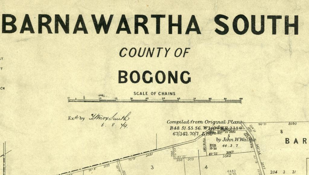
Figure 1: This extract is from record plan B 56 (2), the first record plan created for the Parish of Barnawartha South (VPRS 16306/P1, B 56 (2): Parish of Barnawartha South – Compilation). All the original plans cited here can be found within VPRS 16306 with the exception of NR 2, 3, and 5a, which are from the New Roads sub-sequence of the Historic Plan Collection (VPRS 8168). Annual single number plan numbers 67/342 and 70/7 are also original plans found in VPRS 16306 but are found on plan sheet B56 G in that series. The final plan listed, L.P 8, identifies a locality plan.
Original plans (of survey)
The term ‘original plans’ refers to plans created from surveys, usually conducted to record subdivisions of Crown land.[23] The original plans in VPRS 16306 contain the cadastral information incorporated into the record plans in the same series. Original plans were first created in the local area and sent by a local land office to the Original Plan Room in Melbourne. Prior to dispatch, a local land office usually created a copy of the plan, referred to as a ‘tracing’ due to the fragile tracing paper that was used, although instances exist within VPRS 16306 where the local office retained the original plan and sent a tracing to the Original Plan Room in Melbourne.[24]
Effectively, two types of original plans exist within VPRS 16306. The first type of original plan, which collectively comprise the majority of original plans held within VPRS 16306, are original plans created in the period prior to the creation of the first record plan for each parish or township. The number of these original plans and the date ranges they collectively span vary significantly for each parish or township depending on a couple of factors. The number of original plans are a reflection of the amount of surveying work that was conducted in a particular area before the first record plan was created. The date range of these original plans reflects the interval of time that passed between the creation of the first original plan for the area and the creation of the first record plan.
The second type of original plan in VPRS 16306 are original plans created after the first compilation plan was created for each parish or township (until 1942). These contain information that led to the amendment of the record plan, usually through the inclusion of new allotments, roads, railway lines, reservations or Crown grantee details. Once again, the date range covered by, and the number of, these plans in VPRS 16306 varies significantly according to each parish and township, again depending on the amount of surveying work that was being undertaken after the first record plan was created, but there are no original plans held in VPRS 16306 that date from after 1942. All post-1942 original plans are still held by Land Victoria at Laverton North within a sequence of documents known as survey field notes.[25]
The numbering of record plans and original plans in VPRS 16306
All imperial measure record plans and original plans in VPRS 16306 were allocated plan numbers that initially consisted of an alpha character followed by a number.[26] When the plan numbering system in VPRS 16306 was established at some point between 1855 and the late 1860s,[27] the alpha character represented the first letter in the name of the area, parish or township, and the number was simply a sequence number to distinguish all plans for a particular area, parish or township name starting with the same letter of the alphabet. For example the original plans for the area of Barnawartha[28] were numbered B 45 – B 56 inclusive.
This practice was refined for the numbering of record plans. A specific combination of alpha character and number was adopted to uniquely identify all record plans, and any original plans subsequently used to amend these, for a particular parish or township; the alpha character, for the most part, again represented the first letter in the name of the parish or township. In relation to the previous example, record plans for the Parish of Barnawartha were subsequently numbered using the specific combination B 56 and record plans for the Township of Barnawartha were numbered using the specific combination B 55.[29]
As a general rule, record plans and original plans within VPRS 16306 can be identified based on the characteristics of the plan number as follows:
- The great majority of record plans are identified by an alphanumeric number followed by a number usually in brackets that specifies a version number, for example B 86 (3).[30]
- Original plans created prior to the creation of the first record plan for a parish or township are usually identified solely by alphanumeric numbers without a version number in brackets; for a number of parishes or townships, there will usually be a number of plan numbers, and these will frequently be consecutive numbers.
- Original plans created after the creation of the first record plan for a parish or township until 1942 are identified by an alphanumeric number followed by unbracketed alphabetical characters (e.g., B 86 G) or an alphanumeric one (e.g., B 86 G1).[31]
Original plan numbers[32] were also placed within the actual record plan in the area to which the original plan referred, as shown in Figure 2.
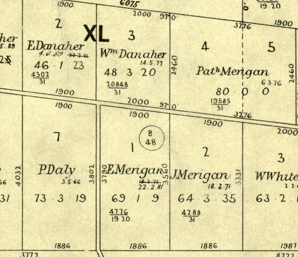
Figure 2: This extract is from record plan B 56 (2) (VPRS 16306/P1, B 56 (2): Parish of Barnawartha South – Compilation), the first record plan created for the Parish of Barnawartha South and shows the location within that record plan of original plan B 48. This is one of the original plans identified in the listing found on the same plan as shown in Figure 1. In some instances where space is at a premium within the allotment on the record plan, the circle is omitted and the number is expressed as a single line of text.
Original plans in VPRS 16306 not numbered according to parish or township
A small number of original plans were identified by a different descriptor, rather than a parish or township name, and the alphabetic letter in their alphanumeric numbers relate to the first letter of that descriptor. The biggest single category of such groupings of original plans within VPRS 16306 refer to the Mallee and are known by the descriptor ‘Mallee Blocks’. Three alphanumeric identifiers were allocated to Mallee Blocks (M 527, M 530 and M 544).[33] Another eight non-Mallee categories have also been identified.[34]
Record plans for parishes and townships that were never created
It appears that the Mallee Blocks original plans were numbered in the manner described to maintain these together in the wake of the surveying effort undertaken there following proclamation of the Land Act 1883. Given the size of the region, it seems it was believed that little would be gained from creating record plans based on individual parishes and townships, at least for the first few decades when the number of allotments surveyed within each parish and township of the Mallee was likely to be small.
While record plans were eventually created for some of the Mallee parishes and townships originally documented in the Mallee Blocks sequence, it has been claimed that hard copy record plans were ultimately never created for 89 parishes and four townships throughout Victoria. These are mainly located in north-east Victoria, the Big Desert area and Gippsland because ‘a sufficient number of Crown subdivision surveys had not occurred to justify their creation’.[35] The record plans for these areas are found within the relevant county plan.[36]
The claim that record plans were never created for just four townships is slightly misleading because record plans for around 40 townships[37] exist solely within the record plan of the parish in which these townships are located. In some instances, these plans are contained within the actual parish record plan, but, for the most part, were reproduced in an enlarged form in the margins of the parish record plan as demonstrated by Figure 3.
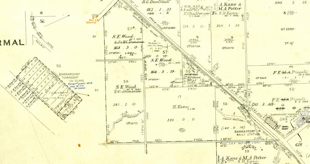
Figure 3: This extract is from the record plan for the Parish of Gredgwin, plan G213 (3) (VPRS 16306/P1, G 213 (3): Parish of Gredgwin – Compilation) and shows what is effectively the record plan for the Township of Barrapoort. Arrows (known as vinculums) point this enlargement towards the actual location of the township within the parish (and vice versa), which is also visible towards the bottom right-hand corner.
Manuscript (record plans)
A manuscript version of (presumably) each record plan is held by Lands Victoria at their storage facility at Laverton North. Manuscript plans are pristine copies (and probably the original) of each version of each record plan and show that version before any subsequent amendments were made. No manuscript plans are held within VPRS 16306 at PROV. Manuscript plans can be identified due to the distinctive manuscript stamp that was placed on them as shown in Figure 4.
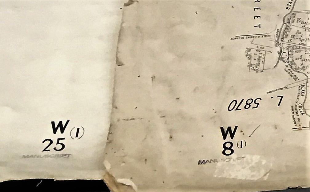
Figure 4: Manuscript plan identifier on plans viewed at Lands Victoria store Laverton North. It should not be concluded from this image that the version number (1), as depicted in both plans next to their alphanumeric numbers, always refers to a manuscript plan, as this is definitely not the case.
The microfiche copies of ‘parish and township plans’ currently held at the Victorian Archives Centre Reading Room are copies of manuscript plans and not copies of the actual record plans, which are contained in VPRS 16306.[38]
Distribution and subsequent use of record plans
All record plans are in the form of lithographs and versions of these were created and distributed to local and regional land offices for use as working plans.[39] As already noted, lithographs were also sold to the public or to any other organisation, government or otherwise.
The first lithographic plans published by the Surveyor-General’s Department were printed in 1853.[40] Department of Crown Lands and Survey staff perfected the means to create reproductions of plans in commercially viable quantities[41] through photolithography by August 1859.[42] In February 1872, it was reported that all original plans held in the Original Plan Room had been photolithographed.[43]
Working plans and VPRS 16171
Lithograph copies of record plans from VPRS 16306 were used as working plans at local and regional land offices and by the Occupation Branch in Melbourne, the latter commonly known as the Occupational Branch (OB) plans.[44] The OB plans were maintained on a current and put away basis,[45] and it is believed that plans held in the regional offices were also maintained on the same basis.[46]
Working plans were essentially working tools created for administrative convenience and, unlike the record plans and original plans in VPRS 16306, were not regarded as legal documents. These were used by staff mainly for two reasons:
- as a pictorial geographic reference tool to record all file numbers for leases and license active at the time[47]
- to record information of correspondence file numbers regarding applications for the use of Crown land but not required to be permanently recorded on a record plan.
Examples of the type of additional information included on a working plan included:
- details of temporary uses of Crown lands such as licensed grazing, short-term business sites and other tenures
- permits that did not involve the sale or reservation of Crown land
- details of inquiries and preliminary dealings that were likely to result in the sale of Crown land but had not yet reached a final stage.
As working plans were subject to heavy use, annotation and thus damage, the great bulk of these were destroyed, usually when a plan had deteriorated beyond the point of repair or when a lithograph of the next version of a plan was created for the relevant parish or township.
Regional Land Office Parish and Township Plans Digitised Reference Set (VPRS 16171)
VPRS 16171 comprises digitised representations of a consolidated reference set of the last hard copy working plans used by regional land offices throughout Victoria prior to the introduction of digital systems in 2001. The hard copy version of these plans never existed as a discrete set and were sourced from, and returned to, the regional offices of origin after digitisation. The hard copy versions of the working plans in VPRS 16171 are not held by PROV.[48]
My examination of VPRS 16171 reveals that, except for the additional information recorded by local offices, most of the items in that series are identical to the record plans in VPRS 16306. However, other plans were adapted for use as substitutes for record plans in VPRS 16171, usually for those parishes or townships for which a record plan had never been created. Examples seen include plans showing national parks,[49] a road traverse survey,[50] grazing allotments[51] and even what appears to be a published version of an auction.[52] Alternate versions of record plans are also included within VPRS 16171 and examples viewed include published versions marked ‘For Departmental Use Only’,[53] township plans that have clearly been cut away from the parish plan within which they were originally created[54] and copies of record plans printed from the microform versions.[55]
Other ‘parish and township plans’ held within PROV and elsewhere
As noted at the start of this article, agencies separate to the Department of Crown Lands and Survey obtained these plans and used them as base maps for records documenting their own information, including the Department of Forests and the Roads Corporation. Such plans are identified in the PROV collection according to the government function these records document.
Most, if not all, of the ‘parish and township plans’ held in non-PROV collections will effectively be one of three types:
- unmarked published lithographs of record plans held in VPRS 16306, probably excess copies of unsold stock received from either a local and regional land office or the Central Plan Office (such record plans are self-evident)
- tracings of original plans held in VPRS 16306 received from a local or regional land office, identifiable by the distinctive fragile tracing paper
- working plans received from either a local or regional land office or the Central Plan Office. These can generally be identified by the mass of annotations on the plan in a variety of different coloured inks, and by reference to the black or blue coloured local identifiers such as seen in Figure 5.
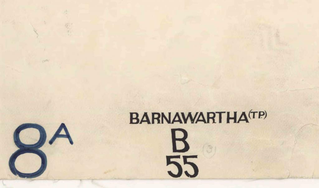
Figure 5: Plan identifiers on a Township of Barnawartha imperial measure working plan from VPRS 16171/P1, Barnawartha(Tp)LOImp5046.pdf Township Plan, Imperial measure 5046. This working plan is a lithograph copy of the relevant record plan from VPRS 16306 but the bracketed version number was not included on the plan supplied to the local land office. The 8A number in blue ink was placed on this plan by the land office from which the plan was sourced for digitisation and was relevant only to staff within that particular office.
Reference sets of record plans and manuscript plans were created in microfiche and aperture cards and were distributed throughout the department, including regional offices and the search room of the Central Plan Room, and from there made their way to PROV and other collecting institutions.[56] These sets are, for the most part, incomplete, as each sequence was originally created by the department to hold just the current version of each parish and township record or manuscript plan at the point the microform sequence was created. For example, the microfiche set of record plans in the PROV Reading Room contains the manuscript plan for all record plans current when that particular set of microfiche was created.
Conclusion: the practical application of this research
This research has resulted, and will continue to result, in the amendment of series titles and series descriptions, the listing of plans in one key consignment and an online document about how to read a parish plan and topic pages. All references to PROV series titles, numbers and so on are as these were at the time of writing prior to any amendments being made subsequently. These changes will not impact on how researchers find online plans in VPRS 16171. However, they will ensure that catalogue entries will restore PROV’s archival obligation to ensure the records in our collection have been adequately delineated and described.
Endnotes
[1] Victoria Government Gazette, 17 September 1875, p. 1792.
[2] Ibid.
[3] Ibid.
[4] Victoria Government Gazette, 12 May 1899, pp. 1508–1510.
[5] The creating agencies identified by PROV for the life of VPRS 16306 are period 1837–1851 Surveyor General’s Branch, Port Phillip Branch (also known as the Melbourne Survey Office); period 1851–1857 Surveyor-General’s Department; period 1857–1983 Department of Crown Lands and Survey; period 1983–?1996 Division of Survey and Mapping (a division within 5 successive departments that existed within this period; period ?1996–2001 Department of Natural Resources and the Environment.
[6] This article does not address how to identify land selection file numbers and how to order these from PROV. For a detailed explanation refer to Lands guide. Finding Victoria’s Crown lands records at the Public Record Office Victoria, 2007, pp. 76–110.
[7] PROV’s approach to these cadastral records started changing after a major accession of records was received early in the 2000s. This accession consisted of a significant number of registers and other series of records that were used by the Department of Crown Lands and Survey to allocate land selection file numbers. This knowledge is documented in the catalogue descriptions for the numerous series received and summarised in great detail within PROV’s Lands guide, which was published in 2007. The microform and digitised plans are now seen merely as the most convenient method for most researchers to obtain these numbers as distinct to the pre-2000 era, which mostly held that viewing the plan to obtain these file numbers was the only way.
[8] The first time these plans were available at PROV was around the year 2000 when microfiche copies were placed in our now closed city reading room as a reference tool to obtain land selection file numbers and were not even documented as part of the PROV collection. The impetus for the placement of VPRS 16171 on our website was to ensure that these digitised plans could be accessed online by the public who wished to find file numbers following publication of PROVs Lands guide. The accession of VPRS 16306 (i.e., the key records from which the microfiche and digitised copies were derived) during 2010 and 2011 was the first for which the explicit intention was the permanent preservation of the plans as state archives.
[9] Some of the other sequences of plans created that come readily to mind are Feature Plans, Contour Plans, Geological Survey Plans and Locality Plans.
[10] Victoria Government Gazette, 22 February 1878, p. 397.
[11] The Central Plan Office (CPO) was constituted under the Survey Co-ordination Act 1940, which did not commence operation until 1945. The plans were relocated from the CPO to another location in the Melbourne CBD before their eventual transfer to PROV.
[12] It is reasonably clear that a raft of changes pertaining to the conduct of surveys, the creation of the first record plans and the relocation of the Original Plan Room were adopted, either anticipating, or as a result of, recommendations stemming from a number of official investigations during this era, including the Royal Commission on the Public Service and Working of the Civil Service Act; the Report on the District Survey Offices (reports from both in Papers presented to Parliament (Legislative Assembly) Session 1873 Vol. 3); and the Board of Enquiry into the Crown Lands Department (report in Papers presented to Parliament (Legislative Assembly), Session 1874, Vol. 3). The earliest of these investigations was the Royal Commission; although its report dates from 1873, this Royal Commission was appointed in 1870 and held meetings and interviewed witnesses between August 1870 and June 1872.
[13] Not all of the present-day parishes and townships were in existence when the first record plans were created, but, after examining the register for the records in VPRS 16306, I have concluded that it was not until some point during the 1920s or more likely the 1930s that the first record plan had been created for every parish or township for which the creating agencies intended to produce one (refer to the section of this article about the parishes and townships for which separate record plans were never created).
[14] Record plans in VPRS 16306 contain references to the existence of sequentially numbered plans prefaced by the words ‘Locality Plan’ or the initials ‘LP’. An example of such a reference can be seen in Figure 1 of this article.
[15] The final Victoria Government Gazette notice of 12 May 1899 also noted that ‘copies of locality plans’ had been prepared for 74 parishes for departmental use only. All of these were for parishes for which, at that time, record plans had not yet been created.
[16] Survey practice handbook, Victoria. Part 2: survey procedures, Surveyors Board Victoria, Melbourne, 1992, Section 3 – Survey Information Sources, p. 3-3. The ‘current status’ essentially means whether the allotment or area is Crown land or not.
[17] Most record plans utilise imperial measurements comprising acres, roods and perches (there are 40 perches in a rood, 4 roods in an acre and 640 acres in a square mile). During the 1970s, an attempt was made to create hard copy record plans in metric measures, but these were created for only 409 parishes and three townships.
[18] Crown grantee details can be found on record plans that predate the Torrens system only for some allotments.
[19] Only the name of the Crown grantee is recorded. Record plans were not used to record the names of any selector who may have previously leased the allotment but did not obtain the Crown grant.
[20] This is the only circumstance under which the name of a Crown grantee will be changed on a record plan as occurred, for example, when the government repurchased privately owned allotments for redivision and subsequent reselection under the Closer Settlement or Soldier Settlement schemes.
[21] The only exception to this is in the circumstances referred to in the previous footnote.
[22] Current record plans today are maintained as digital records. The composition of VPRS 16306 preserves the arrangement of these plans when the use of hard copies ceased in 2001; put-aways are in the P1 consignment and the-then current record plans are in the P2 consignment. Current and put away record plans were never physically together.
[23] The Survey practice handbook uses the term ‘survey plans’ to describe these records. The term ‘original plans’ is used in this article because this was the term used to describe these on the record plans, as demonstrated in Figure 1.
[24] Examples of tracing plans, created and retained by the Ballarat District Land Office, are held by PROV as VPRS 4775.
[25] The post-1942 original plans are identified on record plans by a circle enclosing a number with the prefix letters OP (for original plan) or CP (for certified plan). In the 1970s, a campaign began to change all OP references on record plans to CP ones, but this was abandoned to avoid confusion with a different sequence of CP plans maintained by the Titles Office.
[26] I have deliberately relegated reference to the numbering of the 412 metric plans referred to in footnote 16 to this footnote to avoid unnecessarily complicating reader understanding. Metric record plans were identified according to a unique four-digit number that the department adopted to identify every parish or township. These numbers were also used by the departmental staff in identifying all of the imperial measure plans that were digitised in the set of plans that became VPRS 16171.
[27] Owing to the existence of VPRS 8306/P1, Item 2, it is clear that this system did not exist in 1855. This series is titled Estray Plan Register and Lists Of Plans but the volume in question is identified on its pages as ‘Plans in the Surveyor General’s Office April 1855’. This was the Original Plan Office and the detailed listing of these plans does not show the numbering sequence under which the plans in VPRS 16306 are now controlled. Evidence in a variety of sources suggests the current numbering sequence was in place by 1869 or shortly afterwards and cannot be concisely summarised here.
[28] I have used the term ‘area of Barnawartha’ because, at the time these numbers were allocated, no distinction was made in this numbering system between the Parish of Barnawartha and the Township of Barnawartha, as was also the case in a great number of other instances where parishes and townships shared the same name.
[29] It is thus highly likely that the allocation of these numbers occurred as a necessary precursor to the creation of the first record plan for each parish or township.
[30] A small number of record plans have what appear to be original plan numbers. Their status as record plans thus cannot be identified by number and can only be determined by reference to the register of plans, held by PROV as VPRS 16719.
[31] The plan room stored these plans in VPRS 16306 by attaching these to plan sheets, usually measuring 1 x 0.8 metres, which can contain up to around 10 plans. The numbers (e.g., B86 G) identified a particular sheet. In the example, B86 identifies the parish or township and the alpha suffix G refers to the seventh sheet for that parish or township. It appears alpha suffixes were used instead of numbers to prevent confusion between plan sheets and record plan numbers.
[32] In this instance, the original plan numbers placed on a record plan include the post-1942 OP/CP numbers that are not held within VPRS 16306. Additionally, pre-1942 original plans are identified on the plan by reference to the plan sheet number and this number can appear in a number of points on a record plan depending on the number of plans placed on the actual plan sheet.
[33] The Mallee Blocks plans are numbered across these three alphanumeric numbers and an alphabetical suffix acting as a sequence identifier. Original plan numbers M 527 – M 527 Z (mostly dating from 1885–1887), followed by M 530 – M 530 Z (mostly dating from 1887–1891) and M 544 – M 544 M (dating from 1887–1891).
[34] These categories found in VPRS 16306 are Aboriginal Reserves (A1), Feature Plans (F107, M570 and M571), Quarry Allotments (12 plans numbered Q1–Q12), Runs (R81), Tourist Maps (one plan number T298A) and Unnamed Parishes (plans number U1–U61). A further three categories were created but were placed in VPRS 8168 Historic Plan Collection; these are Agricultural Reserves (also known as Forest Reserves, A173), Certificate Plans (plans number X1–X104), and Contour Surveys (C437) as well as the remainder of the Tourists Maps.
[35] AC Brown (compiler) in ‘Land settlement and the role of the survey’, Section 3 of Survey practice handbook, Victoria. Part 3: land surveying law and administration, Surveyors Board Victoria, 1994 (revised 1997), p. 68.
[36] Working representations of county plans can be found in VPRS 16171.
[37] This is my best estimate at the time of writing this paper.
[38] This particular microfiche set contains only the manuscript plan for each compilation plan current at the time the fiche was produced and does not include the manuscript plan for every version of each parish or township record plan ever created.
[39] It appears that different types of the record plans were created in addition to plans identified by the alphanumeric and bracketed version number. These include record plans for which the alphanumeric plan number seems to have been deliberately omitted or contained defined spaces seemingly for staff to add the alphanumeric number at a later date, and record plans identified as ‘For Departmental Use Only’. Almost all of these types of record plans, including those for departmental use only, appear to have been published (because they contain a purchase price) but examples have also been found of all types in which the price detail does not appear.
[40] Judith Scurfield, ‘Maps and mapping’, eMelbourne. The encyclopaedia of Melbourne online, available at <https://www.emelbourne.net.au/biogs/EM00897b.html>, accessed 3 September 2019. It is unclear if the first lithographs were printed in-house by the Surveyor-General’s Department or by the Victorian Government Printing Office, which was established in 1851. Obviously, these first lithographs were not of record plans, the first of which, as mentioned earlier in this article, date from the late 1860s.
[41] ‘The reproduction of fine line illustrations and map printings was first made workable in commercially viable quantities in the late 1850’s by John Walter Osborne (1828–1902) while working in the Department of Lands and Survey in Melbourne’. John Hannavy, ‘Lithography’, Encyclopaedia of nineteenth-century photography: A–L, p. 865, Google Book, accessed 20 June 2019.
[42] Display of a lithographic stone at Lands Victoria, Level 16, 570 Bourke Street noted by Charlie Farrugia on 1 March 2011. The accompanying panel read: ‘The image appearing on this lithographic stone was produced from a sensitised paper transfer exposed to a photographic negative. This method was perfected for the first time in August 1859 by James W Osborne with the assistance of Mr McHutchison both employees of the Lands Department, Melbourne. It is believed to be the first major break-through in the use of photo lithology.’
[43] Evidence of Henry Byron Moore (assistant surveyor-general) to the Royal Commission on the Public Service and Working of the Civil Service Act, 7 February 1872, p. 222 (Q 6681) in Papers presented to Parliament (Legislative Assembly), Session 1873, Vol. 3.
[44] Peter Cabena, Heather McRae and Elizabeth Bladin, Lands manual. a finding guide to Victorian lands records 1836–1983, Royal Historical Society of Victoria, Melbourne, 1992, p. 11.
[45] Confirmed by Paul Barker, a former employee of the Department of Crown Lands and Survey in conversation with Charlie Farrugia, 2 July 2019. Paul Barker stated that these plans were identified by the use of blue coloured plan numbers. Examples of these can be seen on the digitised versions of a small number of working plans in VPRS 16171 and in Figure 5 of this article.
[46] Phillipa Nelson, ‘Information about locality or working plans Bendigo visit’, internal PROV document, November 2006. Nelson referred to regional offices at that time maintaining ‘Regional Land Office parish and township working plans including superseded plans’.
[47] Of course, if any of these leases or licenses resulted in the lease or license holder becoming the Crown grantee for the allotment, that person’s name, date of grant and file number would be added to the relevant record plan.
[48] The digitisation of the working plans was undertaken by the Department of Natural Resources and the Environment, not PROV. It was undertaken to provide a digital reference copy of these plans for departmental and regional office staff and not for the purpose of permanent preservation as state archives at PROV. The hard copy plans that were digitised were collected from a number of regional offices around the state and were returned to them after digitisation. It is unclear if these hard copies exist today.
[49] Refer, for example, to ‘Wilsons Promontory National Park PA, Imperial measure’ in VPRS 16171, which is used as the ‘parish plan’ for the parishes of Beek Beek, Kulk, Tallang and Warreen.
[50] Refer, for example, to ‘Kevington & Others – Road Traverse Parish Plans, Imperial measure’ in VPRS 16171, which is used as the ‘parish plan’ for the Parish of Lauraville and others.
[51] Refer to ‘Supplementary Grazing Allotments – Wellington River Valley – Parishes of Crookayan Buragwonduc Worrowing and Doledrook’ which is listed as ‘Crookayan 2466, Doledrook 2530, Buragwonduc 2291, Worrowing 3904 allotments Parish Plan, Imperial measure’ in VPRS 16171, as the ‘parish plan’ for each of the parishes involved.
[52] Refer to the plan listed as ‘Cocamba Township Plan, Imperial measure 5183’ in VPRS 16171, which contains a schedule of upset prices for each allotment in the distinctive government gazette font, suggesting it is a reproduction from a Victoria Government Gazette notice.
[53] Refer, for example, to ‘Colbinabbin Parish Plan, Imperial measure 2407’ in VPRS 16171.
[54] Refer, for example, to ‘Garfield – copy Township Plan, Imperial measure G5307’ in VPRS 16171. This plan contains the annotation that it is taken from the plan for the Parish of Bunyip.
[55] Refer, for example, to ‘Nirranda Township Plan, Imperial measure 5599’ in VPRS 16171. The digitised image clearly shows this is a photocopy probably made on an old style ‘wet’ process photocopier. More importantly, this plan also displays the ‘Original Plan Room’ stamp that automatically marks it as a copy of an actual plan from VPRS 16306.
[56] It is also clear that, prior to the introduction of microform, glass plate photographic negatives were created of every plan then in existence, presumably for reproduction purposes. Assistant Surveyor-General Henry Byron Moore reported to the Royal Commission on the Public Service and Working of the Civil Service Act on 7 February 1872 that these were stored in a photolithographic office at the rear of the Original Plan Room (refer to pp. 222 (Q 6681) and 223 (Q 6708) in the published minutes of the commission in Papers presented to Parliament (Legislative Assembly), Session 1873, Vol. 3). Stamps found on some record plans in VPRS 16306 reveals these were filmed on ‘1/1 plate’ until at least 1962. The wording of these stamps reads ‘Department of Crown Lands and Survey PHOTOGRAPHED AT THE ORIGINAL PLAN OFFICE Plan 1/1 Plate Date pre June 62’. These negatives are not held by PROV and it is assumed they were destroyed once the microfilming program was implemented. Each negative appears to have been identified by a sequential number that was also stamped on the relevant plan in VPRS 16306.
Material in the Public Record Office Victoria archival collection contains words and descriptions that reflect attitudes and government policies at different times which may be insensitive and upsetting
Aboriginal and Torres Strait Islander Peoples should be aware the collection and website may contain images, voices and names of deceased persons.
PROV provides advice to researchers wishing to access, publish or re-use records about Aboriginal Peoples