Last updated:
‘Exploiting the high country: a case study of European occupation of the Omeo district’, Provenance: the Journal of Public Record Office Victoria, issue no. 23, 2026. ISSN 1832-2522. Copyright © Anne Beggs-Sunter and Jennifer McCoy
This is a peer reviewed article.
The question of land in Victoria, its availability and its value, consumed the attention of waves of British colonials from the beginning: squatters from the 1830s claimed vast tracts of land as pastoral estates for their sheep and cattle; next, miners arrived, and when their attempts to wrestle fortunes from gold proved elusive, their attention turned to the land. Their struggle to access Victoria’s Crown lands led to political contest, which led to the Land Acts of the 1860s. These Acts gradually made land available for purchase; however, the costs and conditions effectively denied access to miners and small farmers. Moreover, the acreage envisaged was based on British farming conditions and were inappropriate for the land and climate in Victoria.
The high country of northern Gippsland around Omeo, a goldmining area, was one of the last areas to be opened for selection. Examination of the Land Acts passed between 1860 and 1885 reveals how isolation, climatic conditions and the quality of the land tested the selectors and the legislation. The unexpected difficulties eventually led the government to a more realistic assessment of the land and the conditions that could be placed on selectors. Some small selectors eventually succeeded in establishing their families, but only at the expense of unsettling the original custodians of the land, the Yaitmathang people.
During the second half of the nineteenth century, an attempt was made to legislatively convert the colony of Victoria into an agrarian paradise for families. This social engineering dream of land settlement for people irrespective of personal wealth was predicated on the dispossession of the First Peoples of Victoria. Intruders from Van Diemen’s Land (Tasmania) had occupied First Peoples’ lands from the 1830s, bringing sheep and cattle to establish pastoral estates. From 1851, new arrivals from many nations descended, intent on winning a fortune from gold. In reality, most did not win the gold lottery and soon turned to the dream of making a future through establishing farms and transforming the bush into a patchwork of farms and villages.
This article examines the success of a series of Land Acts passed by the Victorian Government between 1860 and 1885, focusing on the high country of northern Gippsland, around the goldmining settlement of Omeo, one of the last areas opened to selection. Geographically remote, isolated by its terrain and challenged by climate, this area would prove incompatible with the dreams of parliamentarians due to the quality of the land. This article illustrates the challenges posed to European settlement; considers the appropriateness of the legislation; and examines, in combination with Aboriginal protection legislation, the impact of selection on the First Peoples in the area. Our aim is to determine whether the Land Acts of 1860–85 were effective in settling agriculturalists upon productive farms, and what impact this had on First Peoples.
Historical and methodological approaches
Since the publication in 1970 of JA Powell’s classic study of land settlement in Victoria, The public lands of Australia Felix, numerous studies have focused on specific areas of Victoria, including the Mallee, the Otways and Gippsland.[1] Peter Cabena’s study of grazing in the high country is especially significant.[2] Among studies of the land management strategies of First Peoples, Ruth Lawrence’s and Peter Gardner’s works stand out.[3] In the 1990s, scholars such as Henry Reynolds and Patrick Wolfe helped to draw attention to the impact of settler colonialism on First Peoples.[4] More recently, the legal implications of colonialism have been investigated by Lisa Ford, culminating in the Yoorrook Justice Commission’s Truth be told in 2025, a foundation stone for the Victorian Treaty.[5] James Belich and others have highlighted the importance of setting land settlement within an international context.[6] Environmental history has also strongly influenced historiography in recent years, with an emphasis on the damage caused to landscapes by European farming practices, the introduction of feral pests and the impacts of goldmining.[7]
This study uses a conventional historical methodology, drawing evidence from archival material – government records and legislation, parish maps, records from the Omeo Shire Council,[8] and regional and local newspapers – supported where possible by secondary interpretations.
Colonial takeover
When John Batman arrived near Geelong in 1835, he attempted to do a deal with local First Peoples, producing a quasi-legal document that purported to buy 600,000 acres of land. Batman’s deed was declared illegal by the British Government, which had decreed by the notion of terra nullius that Australia was ‘unoccupied land’ and, thus, claimed in its entirety by the British Crown. In any case, Batman’s negotiations were only with the Wathaurung and so had no relevance to other parts of Victoria.[9]
In the initial phase of the colonisation of Australia, land was given away by the government to favoured colonists; however, by the 1830s, the sale of Crown land in populated areas was becoming established. In rural areas, squatters held sway, securing vast tracts of land for pastoral use on the payment of an annual licence fee of £10 per year.
Access to land was the single driving focus of the European settlement of Australia and, apart from a few years during the gold rush, this was true of the Omeo region too. Taking ownership of the land meant assuming that it was vacant and available, despite the presence of First Peoples. Henry Reynolds points out that the concept of terra nullius has two different meanings, which are usually conflated: 1) ‘a country without a sovereign recognised by European authorities’ and 2) ‘territory where nobody owns any land at all, where no tenure of any sort exists’.[10] According to Reynolds, while the European powers would have approved the exercise of political power over Australia, the claim that it was a land without occupiers would not have been justified in international law. In other words, the British claim that they were the first occupiers was always questionable.[11] In Victoria, successive Land Acts from 1860, in combination with the Aboriginal ‘protection’ Acts of 1869 and 1886, effectively formalised dispossession.
When the new colony of Victoria was promulgated on 1 July 1851, a small group of white men secured rights over much of the land, as Margaret Kiddle shows in her history of the Western District.[12] However, soon after that proclamation, Victoria was irrevocably changed by the discovery of gold. The flood of gold seekers into the new colony swamped the tiny population of 77,000 white settlers in 1851.
As Geoffrey Serle demonstrates in The golden age, the ‘golden generation’ was formed by the prevailing social, economic and political values of Europe in the 1840s, and many of the new arrivals immigrated in the hope of achieving a better life in the New World. Many were influenced by the ideals of the Chartist movement in Great Britain, which sought democratic political reform and access to land. These ideals became key tenets in the goldfields reform movement of the early 1850s, when organisations like the Ballarat Reform League sprang up to demand changes to the prevailing power system in the colony.[13]
Confrontation over access to land
The demands of reformers overflowed into desperate confrontation at the Eureka Stockade at Ballarat on 3 December 1854 when diggers came into armed conflict with soldiers and police representing the British government. The diggers were quickly subdued, but the causes of the confrontation were taken up in a Goldfields Commission of Inquiry, which reported to parliament in March 1855. The inquiry recommended sweeping changes to the system of administering the goldfields, including a strong recommendation for the sale of land:
24. Out of complaints innumerable on the land question, the Commission will deal, in the first place, with what appears the most important, and upon which their views were most unanimous. These are with regard to the inadequate supplies of the Crown lands to the mining population, and the infrequency of the opportunities afforded to them for purchasing.[14]
The inquiry also recommended that ‘reserves are desirable, as commonage until otherwise required’.[15] This was the first reference to the concept of the goldfields common, which would be incorporated into the Land Acts of the 1860s. The concept of commons surrounding townships was derived from medieval England; commons allowed townsfolk to graze their livestock and cut fuel for their fires.
The call to ‘unlock the lands’ strengthened in 1855–56 with the advent of responsible government in Victoria. The Melbourne Chamber of Commerce met and produced a special report, calling for the colony to be surveyed and land made available in blocks of 40–640 acres, along the American model, with a requirement to cultivate the land. There were strong echoes of the ideas of the English farmer and journalist William Cobbett, who had called for access to rural landholding for labourers impacted by the Industrial Revolution.[16] William Westgarth was critical of the requirement to cultivate the land, arguing that the nature of the land and the climate would determine its best use. He also suggested a tax on unused land, foreshadowing a debate that would rage at the end of the nineteenth century.[17]
When Victoria’s first democratically elected parliament sat at the end of 1856, one of its chief aims was to ‘unlock the lands’ from the hold of the squatters. According to Serle, during this turbulent first sitting, the democratic Legislative Assembly locked horns with the conservative Legislative Council.[18] It would take 13 years for Victoria to secure legislation that safeguarded and encouraged the settlement of genuine small farmers.
Outside parliament, in December 1856, a provisional committee was established for a people’s organisation, the Land League, to fight for democratic land legislation. Thomas Loader, an iron merchant from Melbourne, was its chair, along with the bookseller JJ Walsh.[19] The league’s banner was the Southern Cross and its motto was ‘Advance Australia’.[20] The government responded, in 1857, with the Haines Land Bill, named after William Clark Haines, the first premier of Victoria, whose aim seemed to be to secure the tenure of squatters. With unemployment rising, a popular movement rose against the Haines Land Bill and in favour of government assistance to the unemployed.[21]
A series of public meetings about the proposed land legislation were held at the end of June and early July 1857. Ballarat was caught up in the debate, as many diggers, faced with declining returns from mining, looked to agriculture to supplement their mining activities. The Land League dissolved and became the Land Convention, meeting for three weeks at the Eastern Market in Melbourne, its orderly proceedings reported in the press. Petitions flooded parliament, signed by 70,000 Victorians, calling for land reform, equal electoral districts and payment of members of parliament.[22]
Around Ballarat, miners and timber workers began taking up small blocks of land from 1856, as the government, sensitive to the demands of the Land Convention, began offering parcels of land around the goldfields for auction.[23] Turner claims that 500,000 acres were sold in 1857 ‘at absurdly low prices’.[24] More land was surveyed and put up for sale by auction in 1858 in blocks of 80–160 acres. However, the system favoured existing squatters, who had the capital resources to secure the land.
The beginning of selection
In October 1859, the first parliament elected under manhood suffrage assembled under the leadership of William Nicholson.[25] In December 1859, Minister for Crown Lands James Service introduced a new land selection Bill.[26] The draft Bill met many of the demands of the Land Convention, but heated debate between members of the Legislative Assembly and Council resulted in so many amendments that Nicholson and Service would eventually disown the legislation. Dismayed at the behaviour of the Legislative Council, members of the Land Convention – ‘a clamorous mob’, according to Turner – ‘invaded the Legislative Chambers during the sitting of the House’ on 28 August 1860.[27] This dramatic act broke the deadlock, but the Land Convention members’ violent behaviour turned public sympathies against them. In the end, the Nicholson government accepted the squatters’ 250 amendments and allowed the unrecognisable Bill to pass and be proclaimed on 18 September 1860.[28]
Reviewing the first few months of operation of the 1860 Land Act, Conventionist John Henry Brooke described it as a total failure due to the continuation of the auction system, which consistently advantaged the squatter.[29] Brooke moved a vote of no confidence in the Nicholson government, resulting in a change of government. Richard Heales took office, with Brooke as lands minister. The mobilisation of miners on the goldfields and their increasing influence in the wake of the Eureka Stockade prompted Brooke to approach the auction system in a different way. The Heales government was, in fact, a Convention government. As such, it allowed a liberal interpretation of section 68 of the 1860 Land Act, which granted residence and cultivation licences (originally designed for inns, bridges and ferries) to small holders for up to 20 acres of land.[30] In total, 172,000 acres of land around the goldfields was made available to 1,700 genuine small selectors, including 210 timber workers in the Bullarook forest near Warrenheip, close to Ballarat.[31]
Importantly, the 1860 Land Act also allowed for the reservation of lands for public purposes, and the reservation of town and goldfields commons near townships. As reported in the Ballarat Miner and Weekly Star in December 1859:
But besides these there are some very important provisions affecting commonage reserves, which it is necessary to allude to. There will be ‘town commons’ and ‘gold fields Commons’ the former to be used by the inhabitants of the towns for which the commons may be reserved, and the latter by the holders of miners’ rights, business licenses, and carriers’ licenses, under certain regulations to be made hereafter. Graziers’ licences will also be issued for the purpose of depasturage on gold fields’ commons.[32]
Due to the accommodations forced by squatters, the 1860 Land Act did not allow miners and others of low capital to select land; however, the provision for commonage helped existing small farmers and miners to gain access to land. According to Serle, over two million acres were proclaimed as commonage.[33]
Colonial settlement in northern Gippsland
The high country of northern Gippsland – was challenging for Europeans.[34] The area was traversed by European explorers, including Johan Lhotsky, George MacKillop, James Macfarlane, Angus McMillan and Paul de Strzelecki, from around 1834.[35] From around 1835, its vast grazing lands were controlled by a handful of squatters, who moved stock onto what would become known as the Omeo High Plains. None appeared to live there permanently, relying instead on station managers and stockmen.[36] South of the Great Dividing Range, other parts of Gippsland were more accessible for development, as Watson and others have observed.[37]
For the Yaitmathang, the Traditional Owners of the area, the land was a living entity. It was fundamental to their identity, culture, spirituality, language, law, kinship and sense of belonging (Figure 1). It is a concept unlike European ideas of ownership.[38]
Figure 1: Diagram of eastern Victorian Aboriginal languages and dialects. Source: Ian Clark, ‘Aboriginal language areas in Northeast Victoria: “Mogullumbidj” reconsidered’, Victorian Historical Journal, no. 274, vol. 81, 2010, p. 182. Reproduced with permission from Ian Clark.
Gold was discovered in the high country in 1851[39] and miners quickly moved to the area, negotiating the difficult terrain on foot and with limited access to supplies. In 1856, the European population was estimated to be about 100;[40] by 1861, 900 people were recorded as living in the area, including Europeans, Americans, Chinese and First Peoples.[41] Omeo, known initially as Livingstone, became the administrative centre of the area, with several outlying mining settlements serviced by the smaller townships of Benambra and Swifts Creek (Figure 2).

Figure 2: View of the township of Omeo, 1877. Source: Photograph by NJ Caire. State Library Victoria, H24898.
There were tensions between squatters and miners, as the miners activities upset stock and despoiled land and water sources. However, the main disputes seem to have been confined to squatter Edward Crooke, who was a fierce opponent of the miners.[42] His Hinnomunjie run, which stretched along the Mitta Mitta River and the Livingstone Creek, was the most impacted by the gold rush.[43] As alluvial gold declined, miners focused their attention on land. In April 1858, probably at the behest of miners in the Livingstone Creek area, the Gippsland Guardian reported a petition by ‘the most influential residents of this Creek, and district’ for agricultural land to curtail the ‘present exorbitant prices of carriage for goods’.[44]
In May 1858, Surveyor Skene compiled a comprehensive report on the extent of Crown land still available in Victoria, including in Gippsland. However, he did not distinguish clearly between different classes of land deemed suitable for agriculture. Instead, pastoral land was defined as first, second and third class, based on its sheep carrying capacity.[45] Skene did not visit Omeo. Nevertheless, he recorded a small area of agricultural land around Lake Omeo and noted that the absence of an accessible market for produce prevented the development of agriculture in the area. He also claimed that surveying was far ahead of demand and that, consequently, surveyors had been directed to other projects.[46] That decision would delay surveying and the availability of land in the Omeo area for some time.
Land Acts in northern Gippsland
The 1860 Land Act marked the beginning of the selection era in Victoria, but only successful miners and squatters could afford to purchase land. Land could now be owned but the conditions were difficult. Available land would be surveyed into allotments of between 80 and 640 acres and each allotment would be divided into two equal parts. The purchase of one part at £1 per acre and lease of the other part was obligatory. A deposit of £1 per acre was required and auction followed if there was more than one applicant.
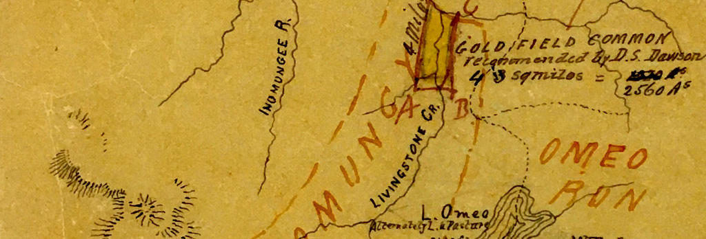
As mentioned, the provision of a goldfields common enabled less successful miners and settlers to access land. However, in northern Gippsland, the commons were problematic from the beginning. The goldfields commons for Omeo and Swifts Creek, gazetted in February 1861, were each allocated 2,560 acres of Crown land (around 4 square miles),[47] much less than the average size of commonage, which was around 7,000 acres.[48] The total area of the Omeo goldfields was estimated to be 640,000 acres (1,000 square miles).[49] Further, as the Gippsland Guardian reported, the location of the Omeo common (Figure 3), which was situated in the centre of Hinnomunjie run, now owned by Matthew Hervey, the representative for Omeo in the Legislative Council, was highly contentious:
Will it be believed that this is the very spot selected to locate the Livingstone [Omeo] diggers’ common? Thus, by a perverse ingenuity doing the utmost possible injustice to both diggers and squatter. In the one case, by placing the common 10 miles from the diggings and camp (which are at that distance up the Livingstone); in the other, by locating it in the midst of the squatter’s fenced and cultivated land.[50]

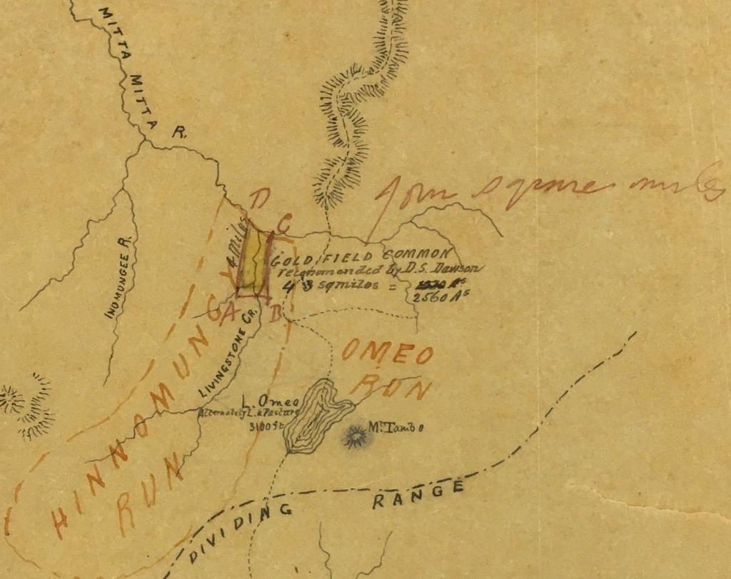
Figure 3: Sketch map showing the location of the Omeo Goldfield Common (above) with inset showing detail (below). Source: PROV, VPRS 242/P0 Crown Reserve Correspondence, C91890, Omeo Goldfield Common Abolition, Omeo, available at <https://prov.vic.gov.au/archive/A9D70F0A-FA4D-11E9-AE98-1F2E3477BA04>, accessed 5 March 2026.[51]
The Land Act 1862 extended the definition of ‘commonage’ to serve multiple purposes for multiple people, including residents within five miles of the goldfields. Subsequently, dairy farmers were allowed to run up to 100 head of cattle on common land.[52] Five petitions were raised to increase the size of the Omeo common,[53] but there were only three minor increases until 1909 when all Victorian commons were abolished.[54] People needed land of their own and a genuine opportunity to build a life on that land.
The first Land Acts valued land at £1 per acre, regardless of quality, and the auction process attracted successful miners, business owners or pastoralists. Pastoralists could also take advantage of the Order-in-Council of 7 October 1847 that allowed them pre-emptive rights to 640 acres.[55] In 1861, three pastoralists in the Omeo region took advantage of this right.[56]
In this remote area, the availability of surveyors and administrators was critical. In November 1861, a Gippsland Guardian correspondent wrote, somewhat cynically, about a:
public notification that the government was going to survey 100,000 acres around Lake Omeo and the Bindi country … [But] when? … [The] assistant surveyor is employed in marking out pre-emptive rights, settling boundary disputes of squatters’ runs and chiefly in surveying and marking out a new line of road to Omeo.[57]
The 1862 Land Act offered little improvement on the previous Act. On 19 December 1862, a journalist noted that ‘a survey of the 25 square miles of so-called agricultural land at Omeo Plains is nearly completed’; however, ‘what is not open plain is either a swamp without an outlet or a thick gum forest … how such a spot came to be selected is a mystery.’[58]
In April 1863, WH Foster was appointed lands officer at Omeo.[59] Following a survey by Assistant Surveyor TW Cooper, sales of Crown land were held in December that year[60] and several miners – Thomas Easton and his partner Clarke; Hans Haas; and James Day, a publican at the diggings – bought multiple allotments at Livingstone Creek/Omeo (Figure 4).[61]

Figure 4: Township and suburban lands at Livingstone Creek, Parish of Cobungra, 1864. Source: State Library of Victoria.
The 1862 Land Act was revised in 1865, offering some hope for small settlers. For example, it allowed full leaseholds of 320 acres instead of immediate purchase, selection and occupation before survey, improvements of £1 per acre to be made after two years and the option to purchase after three years at £1 per acre.[62] These conditions, although something of an improvement, were still challenging. On 4 December 1865, after attending an auction in Omeo, Cooper wrote: ‘There was not one single individual attending the land sale today.’[63]
The selection Acts from 1860 have generally been condemned for failing to successfully establish small farmers on the land.[64] In northern Gippsland, an isolated location with access challenges, the reluctance of government officials to visit probably contributed to the low rate of settlement. The poor quality of the land for farming would be realised later.
The Land Act 1869 was more supportive of small farmers, although, in northern Gippsland, the agricultural dream of 320-acre farming remained elusive. The new Act allowed selection before survey, and rental payments now contributed to the purchase price. It provided an initial licence for three years, dependent on complete enclosure of the land, 10 per cent cultivation, a house built and lived in for three years, all noxious weeds and vermin destroyed, and improvements to the value of £1 per acre. The Act made reference to different types of land being used for different purposes (i.e. agricultural, grazing, pastoral) but it did not explicitly classify soils.
Selection was still slow. According to a report in 1873: ‘There has been very little selection of land for agricultural purposes within the district, but it is fully occupied by pastoral tenants.’[65] More than 12 months later, a group of ratepayers met at the Golden Age Hotel to press for the appointment of a local land board and a district surveyor. They were concerned about inadequate surveys, travel distances and unpredictable administrative postponements.[66]
In 1874, the Department of Crown Lands and Survey was reorganised, and an Occupation Branch with 18 survey districts, each with a District Lands Office, was established. Applications from the Omeo area went first to the Bairnsdale District Lands Office before being referred to the local land board at Omeo to investigate and make recommendations to Melbourne.[67]
Selectors began to arrive, but they still faced huge challenges. Just making their way to the area was difficult. The journey from Geelong took up to three months, with swampy country, multiple creek crossings, floods, and numerous ‘tortuous’ steep tracks, where wheels had to be chocked for descent and branches of trees dragged behind to act as a brake, making the journey dangerous as well as difficult.[68]
Moreover, the process of selecting land was still not straightforward. Settler Patrick Reid, having marked out, or perhaps estimated, an allotment on the Omeo High Plains, had to ride 100 miles on horseback to Bairnsdale to make an application. Long delays accompanied applications and survey costs followed approval.[69]
Some selectors succeeded, but many failed to meet their financial commitments, abandoning their selections. Much of the land was identified as third class pastoral land, as shown in cadastral plans, such as the one for the parish of Tongio-Munjie East (see Figure 5).[70]
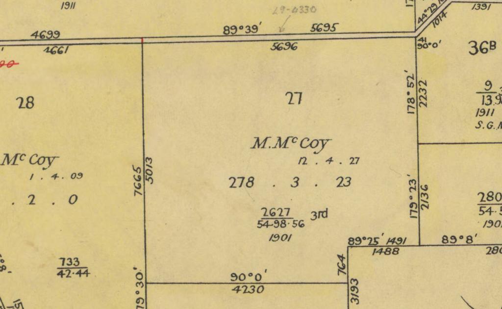
Figure 5: This detail from a cadastral plan for the parish of Tongio-Munjie East shows allotment 27, purchased from the Crown on 12 April 1927 by M McCoy. Directly beneath the date is the size of the land parcel (278 acres, 3 roods and 23 perches). Below that is the land selection file number (which looks like a fraction): 2627 over 54.98.56. The first number is the file number and the latter numbers relate to the relevant sections of the Land Act 1901. ‘3rd’ indicates that this allotment was classified as being third-class pastoral land. Source: PROV, VPRS 16171/P1 Regional Land Office Parish and Township Plans Digitised Reference Set, Tongio-Munjie East (Psh)LOImp3606.pdf, available at <https://prov.vic.gov.au/archive/89A5D5F3-F427-11EA-BE8C-4BD9DFD5547C>, accessed 5 March 2026.
The 320-acre limit was insufficient for agriculture, and although cattle grazing was a more appropriate use for the land, it was still not enough. The responsibilities of selectors under the licence and lease conditions increased their woes. The basic improvements they were required to carry out included ‘ringing’, ‘scrubbing’, and ‘picking up and burning off’, which was defined as fencing, removal of noxious weeds and the burning of waste (see Figure 6).
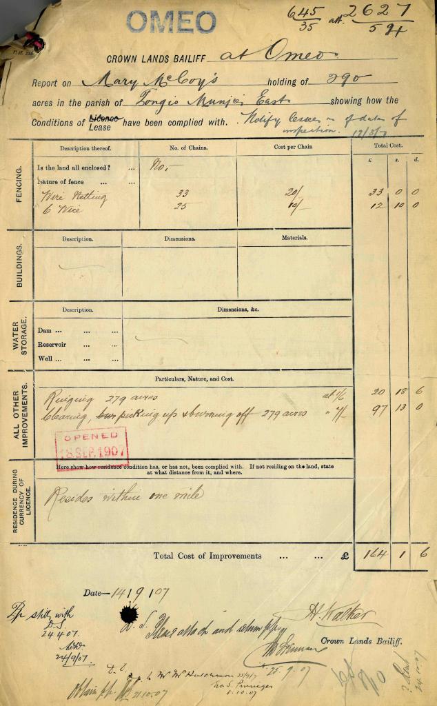
Figure 6: A form from the land selection file (no. 2627) for Mary McCoy documenting improvements to the land she held under lease in 1907. Source: PROV, VPRS 5357/P0 Land Selection and Correspondence Files, 2627/56.98, Mary McCoy; Tongio-Munjie East; 27 1; 278-3-23, available at <https://prov.vic.gov.au/archive/42799D2F-F98A-11E9-AE98-2367F1AC22B8>, accessed 5 March 2026.
A local assessment of the northern Gippsland area was bleak:
Bindi was on a bit of limestone, Ensay is on a big granite magma, Tambo is on a small granite magma … In the early days you did two things, you cleared the granite country for grazing and you ran cattle in the bush.[71]
A Crown Lands Commission of Inquiry was established in May 1878 to examine the effectiveness of the 1869 Land Act. The commissioners did not visit northern Gippsland; however, experienced officials were probed on the climate, accessibility and quality of the land for agricultural development, the 320-acre limit for allotments and the value of grazing leases for selectors. The Commission of Inquiry’s final report included a review of land in the Omeo district by James Stirling, the local lands officer and surveyor. Stirling estimated the quantity of land suitable for grazing or agriculture (or neither) and provided detailed descriptions of the area’s climate, soil quality and vegetation.[72]
This report led to the Land Act 1884, which focused on leasing, rather than selling Crown land. Unalienated Crown lands were categorised into eight classes of land based on productive use, including pastoral, agricultural and grazing. Differences in pastoral land quality were acknowledged, but no attempt was made to classify the quality of agricultural land. Leases for agricultural and grazing lands were set for a fixed term of 14 years, at one lease per person and a maximum of 1,000 acres, at an annual rent of 2–4 pence per acre. The conditions of lease included fencing, the destruction of vermin and restrictions on cutting timber. Women were now permitted to hold a grazing lease or an agricultural licence, depending on their marital status. The amount of purchased land could not exceed 320 acres.
In January 1885, the Omeo Shire Council sent a councillor to Melbourne to press for an alteration to the Act because all the land surrounding Omeo had been classified as first class and valued at £1 per acre, placing settlers there at a disadvantage.[73] In 1889, ‘Vagabond’, a travelling reporter, wrote of the Omeo Plains (Figure 7):
These are all divided and fenced off, every bit of available country … taken under the 320-acre clause, and most of the selectors have also 1000-acre blocks away in the mountain valleys. The selector of old has become a grazier, like the original squatter king.[74]

Figure 7: Omeo, 1890. Source: Photographer unknown. Courtesy Omeo Historical Society.
The architects of Victoria’s Land Acts had hoped to establish small settlers on farms, but this proved to be a type of ‘yeoman myth’.[75] Vagabond’s comment might have been exaggerated, but time would tell that sheep and cattle grazing was the only way to farm in northern Gippsland. Although many selectors were unsuccessful, some of their descendants still farm there today.
Selection and First Peoples
One issue that has mostly been overlooked by historians is how Victoria’s Land Acts formalised the process of assuming ownership of First Peoples’ traditional land. The Central Board for Aborigines was established in 1860 for the ‘protection of Aborigines’ who were to be segregated onto mission stations or reserves.[76] First Peoples could apply for a selection, and, in its 1864 report, the Central Board noted, approvingly, that several applications had been received.[77] However, relatively few First Peoples seem to have applied for, or taken up, selections.
During the second half of the nineteenth century, ‘protection’ grew more restrictive. The Aborigines Protection Act 1869 was issued the same year as the Land Act 1869. The latter made selection more realistic for colonial settlers; the former increased the powers of the Central Board. The 1869 Protection Act required the segregation of all First Peoples on reserves, including those of mixed descent, and allowed for the removal of children. Under the next iteration, the Aborigines Protection Act 1886, First Peoples of mixed descent were removed from reserves. Although such people were theoretically entitled to government assistance in selecting Crown land,[78] the ‘cultural and financial barriers would have been prohibitive for most’.[79] Only a few cases have been documented of First Peoples as selectors, including William ‘Billy’ Thorpe, formerly of Lake Tyers Mission, Gippsland.[80]
Charles Hammond, although not a Yaitmathang man, is generally recognised as belonging to the high country area. He worked at Tongio Station for many years and some of his children worked in Omeo.[81] Twice, in 1864 and again in 1879, he sought to acquire 10 acres of land.[82] On the first occasion, the Central Board advised him to make a formal application to the Board of Land and Works, noting ‘that he might say that the Central Board approved of the application and were prepared to support it’.[83] His application was rejected.[84] In 1879, he applied under the 1869 Land Act.[85] This time the Central Board:
did not think it was advisable that the application should be granted as past experience of several like cases have shown that in no case have the experiments eventuated in anything but failure.[86]
This view was incorrect, as there was evidence at the time of First Peoples being selectors.
Conclusion
According to Tony Dingle, Victoria’s ‘Selection Acts were a triumph of idealism over common sense’.[87] After great struggles in the 1850s and 1860s, the cry went up to ‘unlock the lands’ from the control of a small group of squatters. The Land Acts from 1860 to 1885 sought to allow men of limited capital to buy land and develop productive farms. This idealistic intention was best realised around strong goldfields centres, such as Ballarat. Put to the test in the remote mountainous area of northern Gippsland, the Land Acts proved a failure. Northern Gippsland was not Britain: it was not the place for yeoman farmers. Isolation, difficult terrain and climatic conditions ensured that only pastoral pursuits would succeed there.
Amendments to the Land Acts provided access to women and small farmers. First Peoples also had access – in theory, if not in reality. Ultimately, however, the Land Acts formalised the dispossession of First Peoples from their customary lands. By 1900, most First Peoples in Victoria had been removed to ‘protectorates’, where, according to popular belief, they, as a ‘dying race’, would end their days. In this way, the pastoral lands of Victoria were indeed ‘unsettled’, to use Kate Grenville’s telling phrase.[88]
Endnotes
[1] JA Powell, The public lands of Australia Felix settlement and land appraisal in Victoria 1834–91, OUP, Melbourne, 1970; Charles Fahey, Andrea Gaynor and Katie Holmes, Mallee country: land, people, history, Monash University Publishing, Melbourne, 2019: B Minchinton, ‘That place”: nineteenth century land selection in the Otways, Victoria, Australia’, PhD thesis, University of Melbourne, 2011; B Collett, ‘Land settlement in the Foster area South Gippsland’, MA thesis, University of Melbourne, 1962; Don Watson, Caledonia Australis: Scottish Highlanders on the frontier of Australia, Collins, Sydney,1984.
[2] Peter Cabena, ‘Grazing the high country: an historical and political geography of high-country grazing in Victoria, 1835 to 1935’, MA thesis, University of Melbourne, 1980.
[3] Ruth Lawrence, ‘Northern Gippsland Aboriginal associations with Country: the frontier period, 1834–1859’, in Erik Eklund and Julie Fenley (eds), Earth and industry: stories from Gippsland, Monash University Publishing, Melbourne, 2015, pp. 100–123; Peter Gardner, Gippsland massacres: the destruction of the Kurnai tribes, 1800–1860, Ngarak Press, Ensay, 1993; ‘Some notes on tribal warfare and an event at Tambo Crossing’, Gippsland Heritage Journal, vol. 19, 1999, pp. 41–49.
[4] Patrick Wolfe, Settler colonialism and the transformation of anthropology: the politics and poetics of an ethnographic event, Cassell, London, 1999.
[5] Lisa Ford, Settler sovereignty: jurisdiction and indigenous people in America and Australia, 1788–1836, Harvard University Press, Cambridge, 2010; Yoorrook Justice Commission, <https://www.yoorrook.org.au/>, accessed 22 April 2026.
[6] James Belich, Replenishing the earth: the settler revolution and the rise of the Anglo-world 1783–1939, OUP, Oxford, 2009.
[7] Charles Fahey, ‘The free selector’s landscape; moulding the Victorian farming districts 1870–1915’, Studies in the History of Gardens and Designed Landscapes, vol. 31, no. 2, 2011; Susan Lawrence and Peter Davies, Sludge: disaster on the Victorian goldfields, La Trobe University Press, Carlton, 2019; Dorothy Wickham and Clare Gervasoni (eds), Pay dirt: Ballarat & other gold towns, Ballarat Heritage Services, Ballarat, 2019.
[8] AM Pearson, Echoes from the mountains, Omeo Shire Council, Omeo, 1969.
[9] Bain Attwood, Batman’s treaty and the matter of history, Miegunyah Press, Carlton, 2009.
[10] Henry Reynolds, The law of the land, Penguin, Melbourne, 2003, pp. 14–15.
[11] Ibid., pp. 34–35.
[12] Margaret Kiddle, Men of yesterday, MUP, Melbourne, 1961.
[13] Geoffrey Serle, The golden age, MUP, Carlton, 1963.
[14] Hugh Anderson (ed), The goldfields commission report, Red Rooster Press, Melbourne, 1978, p. 19.
[15] Ibid, p. 24.
[16] William Cobbett, Rural rides, published serially in his Political Register, between 1822 and 1830.
[17] Powell, The public lands of Australia Felix. pp. 65–66.
[18] Serle, The golden age, p. 269.
[19] Miner and Weekly Star, 1857, p. 342; Argus, 29 December 1856, 20 January 1857; Gray, letter to the editor, Age, 5 May 1857.
[20] Serle, The golden age, p. 269.
[21] Henry Gyles Turner, A history of the colony of Victoria, vol. 2, Heritage Publications, Melbourne, 1973 (originally published 1904), p. 100.
[22] PROV, VPRS 18285/P1, 35 petitions printed in Votes and Proceedings, 1856–57, vol. III, <https://prov.vic.gov.au/archive/4CF58411-F9C6-11E9-AE98-C32948D879DC>, accessed 22 April 2026.
[23] Weston Bate, Lucky city, Melbourne University Press, Melbourne, 1978, p. 119.
[24] Turner, A history of the colony of Victoria, p. 100.
[25] Powell, The public lands of Australia Felix, p. 76.
[26] The Miner and Weekly Star, 2 December 1859, carried a complete copy of the Bill.
[27] Turner, A history of the colony of Victoria, p. 83.
[28] Ibid., pp. 81–83; Serle, The golden age, p. 299.
[29] JH Brooke quoted in Serle, The golden age, p. 300.
[30] Turner, A history of the colony of Victoria, pp. 84–85: Serle, The golden age, p. 305.
[31] Powell, The public lands of Australia Felix pp. 81–82, 87; Erica Nathan, Lost waters, MUP, Carlton, 2007, p. 21.
[32] Miner and Weekly Star, 2 December 1859.
[33] Serle, The golden age, p. 300.
[34] Lawrence, ‘Northern Gippsland Aboriginal associations’, pp. 100–123.
[35] Johan Lhotsky, ‘Australian Alps Expedition’, Sydney Gazette, 5 April 1834, p. 3; G McKillop, ‘Australian colonies’, Quarterly Journal of Agriculture, vol. 2, 1836–1837, pp. 156–169; Angus McMillan, ‘Memoirs of trip from Maneroo district in 1839’, in Thomas McBride, Letters from Victorian pioneers, Trustees of the Public Library, 1898, pp. 254–259; LA De Noskowski, ‘Count Strzelecki: an explorer’s letters’, Sydney Morning Herald, 1 August 1936, p. 13.
[36] GA Robinson, The journals of George Augustus Robinson, chief protector, Port Phillip Aboriginal Protectorate, ed. Ian D. Clark, Heritage Matters, Melbourne, 1998, pp. 109–110; Jane Pendergast, Pioneers of the Omeo district, Pendergast, Melbourne, 1968.
[37] Watson, Caledonia Australis.
[38] Victorian Aboriginal Heritage Council, ‘Taking care of culture’, available at <https://www.aboriginalheritagecouncil.vic.gov.au/taking-care-culture>, accessed 23 April 2026.
[39] James Flett, The history of gold discovery in Victoria, Hawthorn Press, Melbourne, 1970, p. 168.
[40] ‘Omeo’, Age, 27 March 1856.
[41] Victoria, ‘Census of Victoria, 1861: population tables. Part III, birthplaces of the people’, Parliamentary paper, no. 74, 1863.
[42] ‘The Omeo diggers and Mr Crooke’, Argus, 3 February 1859, p. 1; ‘Mr Crooke’s Letter’, Gippsland Times, 9 May 1862, p. 3; ‘Omeo’, Ovens and Murray Advertiser, 14 December 1858, p. 3.
[43] R Spreadborough and H Anderson, Victorian squatters, Red Rooster Press, Melbourne, 1983 p. 14.
[44] IAMBI, ‘Omeo Weekly Summary’, Gippsland Guardian, 9 April 1858, p. 3.
[45] Powell, The public lands of Australia Felix, pp. 52–55.
[46] ‘Lands and survey: report of Mr Surveyor Skene’, Parliamentary paper, no. 9, 1858.
[47] ‘Gold fields commons Omeo and Swifts Creek’, Victoria Government Gazette, no. 18, 6 February 1861, pp. 257–260.
[48] Peter Davies, Karen Twig and Susan Lawrence, ‘Common to all miners: the Inglewood gold field common’, Provenance: the journal of the Public Record Office Victoria, no. 16, 2018, pp. 33–42.
[49] ‘Omeo’, Ovens and Murray Advertiser, 29 May 1873, p. 2.
[50] ‘Omeo’, Gippsland Guardian, 7 December 1860, p. 3.
[51] PROV, VPRS 242/P0, C91890, Item 7, Omeo Goldfield Common Abolition: <https://prov.vic.gov.au/archive/A9D70F0A-FA4D-11E9-AE98-1F2E3477BA04>, accessed 22 April 2026.
[52] ‘A Commonage System’, Argus, 9 July 1857, 4; Victoria, ‘Graziers’ license regulations for gold fields commons’, Parliamentary paper, no. 6, 1861; Victoria, ‘Additional regulation relating to graziers' licenses for gold fields commons’, Parliamentary paper, no. 68, 1861.
[53] PROV, VPRS 242/P0, C91890, Omeo Goldfield Common Abolition; Omeo, <https://prov.vic.gov.au/archive/A9D70F0A-FA4D-11E9-AE98-1F2E3477BA04>, accessed 22 April 2026.
[54] Victoria Government Gazette, no. 79, 23 June 1909, p. 2789.
[55] United Kingdom, ‘Order-in-Council’, House of Commons Papers, no. 252, 1847.
[56] Victoria Government Gazette, no. 173, 26 November 1861, p. 2288.
[57] ‘Omeo’, Gippsland Guardian, 8 November 1861, p. 3.
[58] ‘Omeo’, Gippsland Guardian, 19 December 1862, p. 2.
[59] Victoria Government Gazette, no. 42, 28 April 1863, p. 909.
[60] PROV, VPRS 873/P1, Omeo, Omeo 892, 1863, <https://prov.vic.gov.au/archive/15CC90E3-F303-11E9-AE98-3D3209AB884E>, accessed 22 April 2026; PROV, VPRS 873/P1, Omeo, Omeo 887, 1863, <https://prov.vic.gov.au/archive/15C9F8D1-F303-11E9-AE98-37AE730A6A96>, accessed 22 April 2026.
[61] PROV, VPRS 873/P1, Omeo, Omeo 887, 1863.
[62] Phillippa Nelson and Lesley Alves, Lands guide, PROV, Melbourne, 2009, p. 52.
[63] PROV, VPRS 873/P1, Omeo, Omeo 1617, <https://prov.vic.gov.au/archive/54011860-F303-11E9-AE98-BFCB37DAD457>, accessed 22 April 2026.
[64] Richard Waterhouse, ‘Agrarian ideals and pastoral realities’, in DA Roberts and M Crotty (eds), The Great mistakes of Australian history, UNSW Press, Sydney, 2006, p. 69.
[65] ‘Omeo’, Ovens and Murray Advertiser, 29 May 1873.
[66] ‘Omeo’, Gippsland Times, 28 July 1874.
[67] Nelson and Alves, Lands guide, p. 213.
[68] Pendergast, Pioneers of the Omeo district, pp. 65–70.
[69] Patrick Reid, letter to his wife, 1876, courtesy Bruce and Sue Reid, Marlo, Victoria.
[70] PROV, VPRS 16171/P1, Tongio-Munjie East (Psh)LOImp3606.pdf, <https://prov.vic.gov.au/archive/89A5D5F3-F427-11EA-BE8C-4BD9DFD5547C>, accessed 22 April 2026.
[71] WH Davidson, Tales of the Tambo Valley, Davidson, Sydney, 1981, p. 4; PROV, VPRS 8168/P2, RUN132; BINDI TONGIO MUNDI NUNNIONG; STRONG n.d.; PROV, VPRS 8168/P2, RUN546; ENSAY, 1875; VPRS 8168/P2, ET80A; TAMBO - OMEO; ALLAN, 1879.
[72] Victoria, Crown Lands Commission of Inquiry, ‘Report on both the agricultural and pastoral occupation of the public lands’, Parliamentary paper, no. 73, September 1879, Appendix D, Omeo Survey District.
[73] Pearson, Echoes from the mountains, p. 118
[74] The Vagabond, ‘Across the main divide: no. 1’,Age, 27 April 1889, p. 4.
[75] JM Powell (ed), Yeomen and bureaucrats: the Victorian Crown Lands Commission 1878–79, OUP, Melbourne, 1973, p. xiv.
[76] Richard Broome, walata tyamateetj. A guide to government records about Aboriginal people in Victoria, PROV and NAA, Melbourne, 2014, p. 13, available at <https://prov.vic.gov.au/walata-tyamateetj-research-guide>, accessed 27 April 2026. .
[77] Victoria, Central Board for Aborigines, Fourth Report, 1864, p. 10; Richard Broome, Aboriginal Victorians: a history since 1800, Allen & Unwin, 2005, pp. 160–161.
[78] Ibid., p. 161; Broome, walata tyamateetj, pp. 13–14.
[79] Nelson and Alves, Lands guide, pp. 160–161.
[80] Ibid., p. 161; Broome, Aboriginal Victorians, pp. 161–162.
[81] Michael Young, Ellen Mundy and Debbie Mundy, The Aboriginal people of the Monaro, National Parks and Wildlife Service, Sydney, 2000, pp. 317–319.
[82] Bain Attwood, ‘Off the mission stations: Aborigines in Gippsland 1860–1890’, Aboriginal History, 1986, pp. 131–150.
[83] National Archives of Australia, minutes, 15 August 1864, Central Board Appointed to Watch over the Interests of the Aborigines in the Colony of Victoria, single number series contains digital images of [1] to [3], c. 1860–c. 1885, [microform], Series B314 Roll 1, Item 32045807, p. 181.
[84] Bain Attwood, ‘Charles Hammond: Aboriginal battler’, Gippsland Heritage Journal, no. 5, 1990, pp. 15–17.
[85] Ibid., p. 15.
[86] National Archives of Australia, minutes, 6 August 1879, Central Board Appointed to Watch over the Interests of the Aborigines in the Colony of Victoria, single number series contains digital images of [1] to [3], c. 1860–c. 1885, [microform], Series B314 Roll 1, Item 32045807, pp. 364–365; PROV, VPRS 242/P0, A10001, Crown Reserves Correspondence, Board for Protection of Aborigines rejects request by Charles Hammond for certain land Land Application; Tongio-Munjie; 10--0—0, 1879.
[87] Tony Dingle, The Victorians: settling, Fairfax, Syme & Weldon, Sydney, 1984, p. 63.
[88] Kate Grenville, Unsettled: a journey through time and place, Melbourne, Black Inc, 2025.
Material in the Public Record Office Victoria archival collection contains words and descriptions that reflect attitudes and government policies at different times which may be insensitive and upsetting
Aboriginal and Torres Strait Islander Peoples should be aware the collection and website may contain images, voices and names of deceased persons.
PROV provides advice to researchers wishing to access, publish or re-use records about Aboriginal Peoples