Author: Public Record Office Victoria
If you’re the inquisitive type you may have wondered how a place, park or building got its name or even what it means. As part of the Land Management, Place Names record series (VPRS) 17888 recently transferred to our archives, you will be able to uncover how and why many Victorian geographic places got their names between 1998 and 2010.
The practice of naming or renaming a public place is often a lengthy process driven by consultation between local councils, communities and stakeholders. The proposed name then goes before the regulatory body, the Office of Geographic Names, for approval. The records created as part of this process often include council minutes, maps or plans of the place under consideration and official correspondence with stakeholders that detail the significance of the proposed name.
These records, now available to order and view at the Victorian Archives Centre, document the cultural significance of a place name including places named to reflect the local Aboriginal community or original title, for example:

Kirrip Warrung Biik Park, Werribee
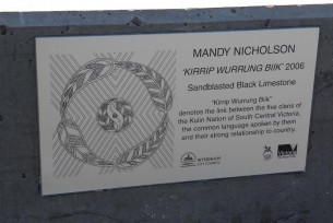
Adjacent to the Wyndham Cultural Centre, this parkland was the site of a commissioned artwork that brought together creative ideas from members of all five Kulin Nations.
To promote the artwork’s themes, particularly friendship between the Kulin Nations, the park underwent a name change to ‘Kirrip Warrung Biik’, literally meaning ‘friend mouth country’. Kirrip denotes friendship, Warrung is the common language spoken, and Biik represents their strong connection to country, creating an appropriate name for the park.
Galada Tamboore Pathway, Craigieburn Bypass bicycle-pedestrian path
Constructed alongside the Craigieburn bypass, this shared pathway was named through a community nomination process held by VicRoads. The nominated ‘Galada Tamboore’ was then investigated by VicRoads in consultation with the Wurundjeri Tribe Land and Compensation Cultural Heritage Council. Galada Tamboore is derived from the nearby 93-hectare floodplain, which is of great archaeological, geological and historical significance. More can be read and discovered about Galada Tamboore and the VicRoads' naming nominations by ordering this file.
Wayaperri House, Werribee
In 2004, the Wyndham City Council purchased the former St Phillip’s Lutheran Church Hall so it could be used as a community meeting facility by the Werribee Community Centre. The hall is now known as Wayaperri House. ‘Wayaperri’ meaning ‘to meet’ is an Indigenous name that is locally relevant and is an appropriate reflection of the current use of the hall.
By viewing the records, one learns that the Werribee Community Centre had originally proposed calling the hall ‘Milpara Place’, but having consulted the Victorian Aboriginal Corporation for Languages, found that the closest word to ‘Milpara’ in the Boon Wurrun language was ‘Milpala’ meaning ‘crooked’, as in a bend in the river.
These records are now available to order and view at the Victorian Archives Centre Reading Room. Search the collection now.
Note, place name records created prior to 1998 are currently in the custody of Land Victoria.
Material in the Public Record Office Victoria archival collection contains words and descriptions that reflect attitudes and government policies at different times which may be insensitive and upsetting
Aboriginal and Torres Strait Islander Peoples should be aware the collection and website may contain images, voices and names of deceased persons.
PROV provides advice to researchers wishing to access, publish or re-use records about Aboriginal Peoples
